Trails for everyone, forever

Home Go Hiking Hiking Guide Nosh Nosh Wahtum

Help power WTA's essential work for trails and hikers. GiveBIG on May 7-8 or by making an early gift today. Thank you for your generosity!


Nosh Nosh Wahtum

Snoqualmie Region > Salmon La Sac/Teanaway
47.5435, -121.0968 Map & Directions
Length
5.0 miles, roundtrip
Elevation Gain
1,500 feet
Highest Point
4,850 feet
Calculated Difficulty About Calculated Difficulty
Moderate
Nosh Nosh Wahtum on a sunny day. Photo by Jessica Wynne. Full-size image
  • Dogs allowed on leash
  • Established campsites
  • Good for kids
  • Lakes
  • Old growth
Saved to My Backpack

Get a taste of the Alpine Lakes Wilderness on this short climb to a small but scenic lake. The trail winds from a lush meadow into old growth forest. Whether as a short day trek or a first-time overnight, a hike to Nosh Nosh Wahtum is worth the long road in. Continue reading

Rating
3.80 out of 5

(5 votes) Log in to rate

Hiking Nosh Nosh Wahtum

Note: The previous name of this lake included the term “sq---” which is considered a derogatory and offensive slur by North American indigenous groups. WTA supports the ongoing efforts to rename the many geographical places that bear this name.

The short trail up to Nosh Nosh Wahtum begins at the sign for Cathedral Trail No.1345. The lake is not listed on the trail sign, but you won’t miss it on the way up. Spy Cathedral Rock jutting forth from the ridgeline to the northwest. Follow the trail through the rich Tucquala Meadow, which quickly gives way to thick forest. Cross the bridge over Cle Elum River, and continue up and through the trees, noticing some of the old growth behemoths that watch over the valley.

In late summer, huckleberries and salmonberries line the trail, although the ones higher up the ridge will take more time to ripen. At 0.5 mile, cross into the Alpine Lakes Wilderness. Once within the wilderness, the long switchbacks gradually bring you up the hillside, offering peeking views of the green valley below and the rusty mountain peaks to the east.

At 2 miles, reach a signed junction with Trail Creek Trail 1332 and continue straight. The trail becomes rockier and steeper after the junction, but you’re almost to the lake. Just before the lake, notice a toilet sign nailed to a tree on your left; there is a composting toilet just down the way.

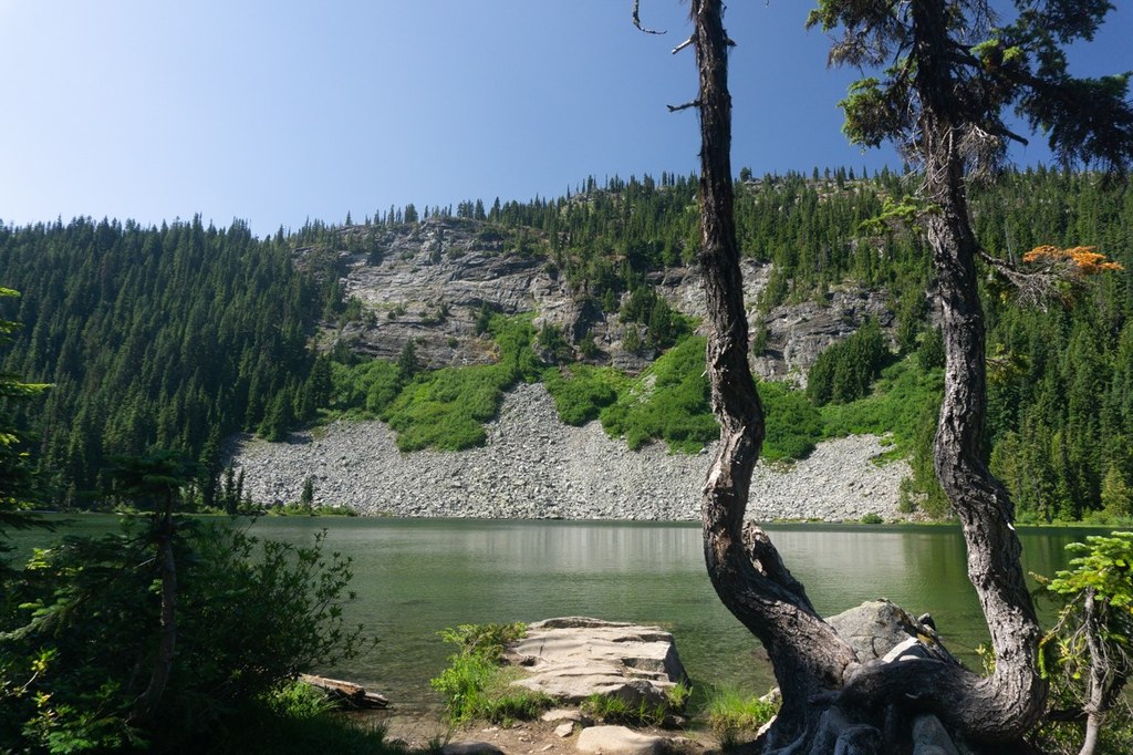
Continue straight to arrive at the glittering, quiet lake. There are several trails snaking around the lake to various campsites, any of which make a great picnic or overnight spot. There is a designated horse camp located on the lake’s north side. The water can be surprisingly warm and clear, and you’re sure to spot frogs and other creatures nearby. Return the way you came, or extend your trip by continuing up to Cathedral Pass.

Hike Description Written by
Jessica Wynne, WTA Correspondent

Nosh Nosh Wahtum

Map & Directions

Trailhead
Co-ordinates: 47.5435, -121.0968 Open in Google Maps

Before You Go

See weather forecast

WTA Pro Tip: Save a copy of our directions before you leave! App-based driving directions aren't always accurate and data connections may be unreliable as you drive to the trailhead.

Getting There

From Seattle: Take I-90 east to exit 80 toward Roslyn/Suncadia. Turn left onto Bullfrog Road. Drive 2.1 miles, at the traffic circle, take the first exit to continue on Bullfrog Road. Drive another 0.7 miles, continue straight through the traffic circle onto WA-903 N.

From Ellensburg: Take I-90 west to exit 84 toward Cle Elum. Turn right onto Oakes Ave, follow for a 0.5 mile, then turn left onto W 2nd St/WA-903 N. Drive 2.2 miles and take the first exit at the traffic circle to stay on WA-903 N.

Continue through Roslyn, then turn left onto W Nevada Ave/WA-903 N. Follow the road right as it becomes N 7th St/WA-903 N. Continue for 14.8 miles until the end of the maintained road. Take a slight right onto Cle Elum Valley Rd/NF-4330. The rest of the drive is on a gravel road with varying conditions, and low clearance vehicles should use caution.

Continue past all turn offs, and slow down through private land and campground areas. After 9 miles on NF-4330, Scatter Creek flows over the road and could be impassable in early spring. At 12.3 miles, take a slight left onto NF-153, where the parking lot is located.

Notice the signs for designated horse trailer parking alongside the road, and park in the car lot near the restrooms. There is room for about 15 cars, plus more space alongside the road. There are picnic tables and pit toilets but no trash cans. This parking area is often near full as many backpacking treks begin here. A Northwest Forest Pass is required to park, and there is no pay station at the lot. A Wilderness Permit box is located at the “Cathedral Trail No.1345” sign.

More Hike Details

Trailhead

Snoqualmie Region > Salmon La Sac/Teanaway

Cathedral Pass Trail (#1345)

Okanogan-Wenatchee National Forest, Cle Elum Ranger District

Guidebooks & Maps

Alpine Lakes Wilderness: The Complete Hiking Guide (Nathan Barnes & Jeremy Barnes, Mountaineers Books)

You can improve or add to this guidebook entry!

Nosh Nosh Wahtum

49 Trip Reports

Hiked here recently?

Submit a trip report!
 
Trip Reports