Article

Determining Attribute—Response Relationships of Soils under Different Land Uses: A Case Study

by
Cristian Vasilică Secu
1,
Dan Cristian Lesenciuc
1,
Ionuț Vasiliniuc
1,2,*,
Gabi Zaldea
3,
Ancuța Nechita
3 and
Lulu Cătălin Alexandru
3
1
Department of Geography, University Alexandru Ioan Cuza of Iași, 700506 Iași, Romania
2
Geography Research Center, Romanian Academy, Iași Branch, 700481 Iași, Romania
3
Research and Development Station for Viticulture and Winemaking Iasi, 700489 Iași, Romania
*
Author to whom correspondence should be addressed.
Land 2023, 12(9), 1750; https://doi.org/10.3390/land12091750
Submission received: 31 July 2023 / Revised: 31 August 2023 / Accepted: 5 September 2023 / Published: 8 September 2023

Abstract

:
Soil researchers are interested in a gaining better understanding of the soil system state by analyzing its properties and their dynamics in time as well as in relation to land use change. Tilled, abandoned, and forest soils were assessed regarding attribute–response relationships for the bulk density (BD), total porosity (TP), volumetric moisture (θv), and penetration resistance (PR) with the use of the interquartile ratio (IRI) integrated into a resilience formula and Shannon entropy indices. The IRI results differentiated soil properties according to agrotechnics (wheel track vs. between wheels) and the state of the system (tilled vs. abandoned vineyard). Entropy (En) indicated a high level of uncertainty for PR. The linear regression applied to the pairs of BD-TP, TP-θv, and PR-θv showed better results for the IRI weight (IRIweight) compared to the entropy weight (Enweight) for the soil between the wheels. The soil of the abandoned vineyard showed a faster tendency toward resilience that was more pronounced in the tilled wheel tracks than in the area between the wheels. The IRI can thus be an alternative to entropy in the evaluation of the response of some soil properties according to their use. When integrated into a resilience formula, the IRI can estimate the dynamics of soil properties for abandoned land compared to reference soil.

1. Introduction

Entropy is a measure of our confusion regarding the state of a system [1]. Characterizing the state of the soil system is an open topic in science, and the various types of entropy are a useful tool in this endeavor. Entropy is frequently associated with measuring the heterogeneity of properties with high stability (e.g., soil texture) [2], but several studies used Shannon entropy to characterize changes in the soil system under different management practices [3,4]. Several types of entropy have been mentioned [5], but the interpretation of the results was different. Soil evolution is marked by antagonistic processes and actions. Thus, local perturbations and dynamic instability contribute to an increase in the spatial variability of soils and consequently to entropy [6], while the formation of soil structure is accompanied by a decrease in entropy [7].
Starting from a known property, entropy is used as a predictor for other physical properties of the soil, but the results should be interpreted with caution [8,9], as they are highly dependent on soil type, land use, etc. When applied to the soil system, entropy has inherent limitations, highlighting the need to find an alternative method for assessing the soil condition at one time.
Soil resilience is the ability of the soil to recover its original level of performance or state after a disturbance [10,11]. The approach to resilience in many studies regarding soils was based on their properties and indicators [12,13]. Resilience can be calculated using simple mathematical equations in the form of ratios [11] and differences [14] but also with more complex equations [13]. In this study, resilience was calculated for properties that exhibited stability over time (e.g., bulk density and total porosity). Resilience is viewed as a “meta-function”, as it is the result of the past and present management but provides insight into the evolution of the system in the future [15].
Only a few articles integrated entropy into resilience [14], but entropy is dependent on the sample size [16]. The knowledge of the soil condition at a given point in time should be analyzed with an indicator that shows stability with respect to the sample size and that—when integrated with resilience—can provide information on the evolution of soil properties and the relationship between them.
Our study aimed to test the capacity of two dimensionless indicators (the interquartile ratio index and entropy) with the purpose of ranking the soil’s physical properties in the case of three types of land use (cultivated vineyard, abandoned vineyard, and forest). The objectives of this study included: (1) creating a database of the soil’s physical properties; (2) identifying through statistical analysis the differences in the soil’s physical properties based on land use; (3) analyzing the attribute–response relationships for the soil’s physical properties by using IRI, the index proposed in this study, and Shannon entropy as indicators of the system state; and (4) integrating IRI into the resilience formula to assess changes in properties in the disturbed soil compared to the reference soil.

2. Materials and Methods

2.1. Study Area Characteristics

The studied territory is in Romania at the northern limit of the Iași municipality (47°14′5″ N and 27°29′41″ E, 47°12′14″ N and 27°32′3″ E) (Figure 1a).
In this study, three areas with various terrain uses were selected, including both an active and an abandoned vineyard inside the Research and Development Station for Viticulture and Winemaking Iasi (RDSVW) and a close area with forested vegetation. The vineyard plots are situated on a plateau with an elevation of 180–210 m and a slope < 5% in the NW-SE direction. The third site (chosen as a sample for natural conditions) is situated nearby (3.5 km NE) in the Mârzești Forest at a 170–175 m altitude (Figure 1b).
Several studies have shown aggressive deforestation in the last centuries in the tableland area of eastern Romania [17,18]. The average age of the trees in the sampled forest area is now about 50 years, but a few oaks dated to at least 200 years ago, indicating the stability of the soil’s evolution.
The vegetation falls within the forest-steppe zone, and the most common species are Quercus robur, Q. pedinculiflora, Fraxinus excelsior, Ulmus minor, Acer campestre, and Tilia cordata [19]. As a result of extensive clearing for agriculture and vineyards, many forests nowadays are discontinuous [20] and occur as small areas [21], particularly on slopes.
The soils were classified according to the International System for Soil Classification [22] as follows: Aric and Cambic Chernozems were identified in the vineyards, while Cambic Chernozems dominated in the forest area nearby. The soils were developed on loess-like deposits resulting from the diagenesis of Sarmatian-age clays. The texture as interpreted according to USDA 2017 [23] was clay loam (sand = 33.8%, silt = 30%, clay = 36.2%) in the Am topsoil horizon [24], and it changed very little in the following Ap horizon (sand = 37.6%, silt = 26.2%, and clay = 36.2%) in the vineyard.

2.2. Management Practices

The establishment of the vine plantation started with soil loosening at 50–60 cm, identified in the soil profiles by an abrupt change in morphological characteristics. The rows were arranged at 2.2 m, and the spacing between plants (stumps) was 1.2 m.
Vineyard management for both the abandoned and nowadays cultivated vineyard was and is conducted by alternating ploughed rows with grassed rows dominated by perennial species. The alternation of the weeded rows with the tilled rows has remained unchanged in the RDSVW Iasi from 1977 until 2023. The sequence of work on the ploughed rows consists of autumn ploughing (16–18 cm) with turning the furrows toward the rows of vines, spring ploughing (14–16 cm) with a vine cultivator plough equipped with side plough shares for turning the furrows toward the middle of the row, and deep tilling of the soil on the row of vines at 8–10 cm (manual work). The grass-covered strips are mechanically mowed 2–3 times per year. On the ploughed row, the machines can pass about 12 times per year, while on the weeded row, the number of passes is 10 times per year. Subsoiling work is carried out with a subsoiler on the tractor tracks once every 4–5 years, with the last such work being done in 2018 on the rows with grass-covered strips.
An 11-hectare plot located southwest of the cultivated vineyard was removed from the resort property in 2011 in accordance with the Land Law issued by the Romanian government (1991) (Figure 1; yellow points). After this date, maintenance works similar to those in the cultivated vineyard were stopped. At this time, spontaneous vegetation completely covered the soil, making it difficult to distinguish between the originally grassed and ploughed rows in the field. Various spontaneous forest species such as ash and maple grew throughout along with a few fruit trees such as cherry and walnut.

2.3. Soil Sampling and Analysis Methodology

Systematic grid sampling with 75 × 75 m point spacing generated in ArcGIS (Environmental Systems Research Institute, Redlands, CA, USA) was the basis for sampling the cultivated and abandoned vineyards (Figure 1). In the forest, constraints imposed by relief (slope) and anthropogenic activities (e.g., war trenches) required sampling on a systematic 50 × 50 m grid (Figure 1a). In addition, three control points (50, 51, and 52) were placed near the cultivated plot in order to have a measure of comparison. The coordinates of the sampling points were acquired with a RTK Unistrong G975 geodetic GPS, after which the points were imported into ArcGIS 10.8.
Precipitation and temperatures were recorded using an Adcon Telemetry-Agroexpert station at the RDSVW Iasi. Sampling was conducted in June 2021, precisely four days after the rainy period (Figure 2), when the soil moisture reached field capacity.
To examine the variability in the soil characteristics such as the bulk density (BD), total porosity (TP), volumetric moisture (θv), and penetration resistance (PR), sampling was carried out in different positions of the vineyard (along the wheel track and between the wheels) (Figure 3). Thus, samples were collected from the tilled and grass-covered strips, and measurements were made along the wheel track and between the wheels (Figure 3a,b). Cylinders measuring 100 cm3 were collected from the surface horizon along each wheel track, and two measurements of the PR were performed (0–30 cm). Between the wheels, two soil cylinders were sampled and two measurements of the PR were performed, with some differences observed between the cultivated and abandoned vineyard. In the ploughed row, one cylinder was taken from the surface (0–6 cm) and the second from a 14–20 cm depth to observe the effect of the ploughing (Figure 3a). In the abandoned vineyard, the presence of plough pans could not be identified, and similar to the grass strip, the cylinders were taken from the soil surface (Figure 3c). In the forest vegetation area, two cylinders were sampled from the A horizon (0–6 cm) for each point, and two measurements for RP were conducted (0–30 cm) (Figure 3d). According to the proposed methodology, 116 soil cylinders were sampled from the cultivated vineyard, 60 from the abandoned vineyard, and 38 from the soil beneath forest vegetation (details are provided in Table 1).
To ensure comparable results, field activities were carried out when the soil moisture was at an appropriate level for field capacity. Sampling was conducted using 100 cm3 cylinders, and the water content was determined gravimetrically using the thermogravimetric method [25]. The gravimetric water content was then converted to volumetric water content, which is more commonly used [26]. Next, using the same sample, the volume of the solid phase of the soil was determined with an air pycnometer according to Langer [27]. Undisturbed core soil samples were dried at 105 °C, weighed, and used to calculate the BD, TP, and θv [25,28,29].
The RP determination was performed with a Eijkelkamp model penetrologger (Netherlands) equipped with a 60° inclination cone with a surface of 1 cm2 [30]. The penetrologger was equipped with an ultrasonic sensor that measured the penetration depth of the cone, so it was possible to obtain the penetration resistance at different depths [31]. To eliminate errors as much as possible, the measurements were made by one single person.
Data in numerical format were downloaded with PenetroViewer V6.08-Eijkelkamp software and exported to Excel (Microsoft, Washington, DC, USA). The interpretation of the PR values was based on the following classes: very low (≤1 MPa, no limitation); low (≤1 ≤ PR ≤ 2.5 MPa); medium (2.6 ≤ PR ≤ 5.0 MPa); high (5.1 ≤ PR ≤ 10.0 MPa, critical restriction); very high (10.0 ≤ PR ≤ 15.0 MPa, virtually no root growth); and extremely high (PR ≥ 15.0 MPa, no root growth) [32].

2.4. Statistical Analysis

Each type of land use (cultivated vineyard, abandoned vineyard, and forest) was considered as a system, and each type of agrotechnique became a subsystem; this division allowed for several “actors” to play a role [33] in this research. Descriptive statistics (minimum, mean, maximum, standard deviation—StDEV, skewness, and the Shapiro–Wilk test) were performed using SPSS 16 (Chicago, SPSS Inc., Chicago, IL, USA). The Shapiro–Wilk normality test was preferred to other tests because it provides good results using a few samples [34]. Differences between the means of the physical properties (BD, TP, PR, and θv) for soils in the cultivated and abandoned vineyards and under the forest were investigated using one-way analysis of variance (ANOVA) followed by the Tukey–Kramer test.

2.5. Attribute–Response Relationships Assessed Using Entropy and Interquartile Report Index
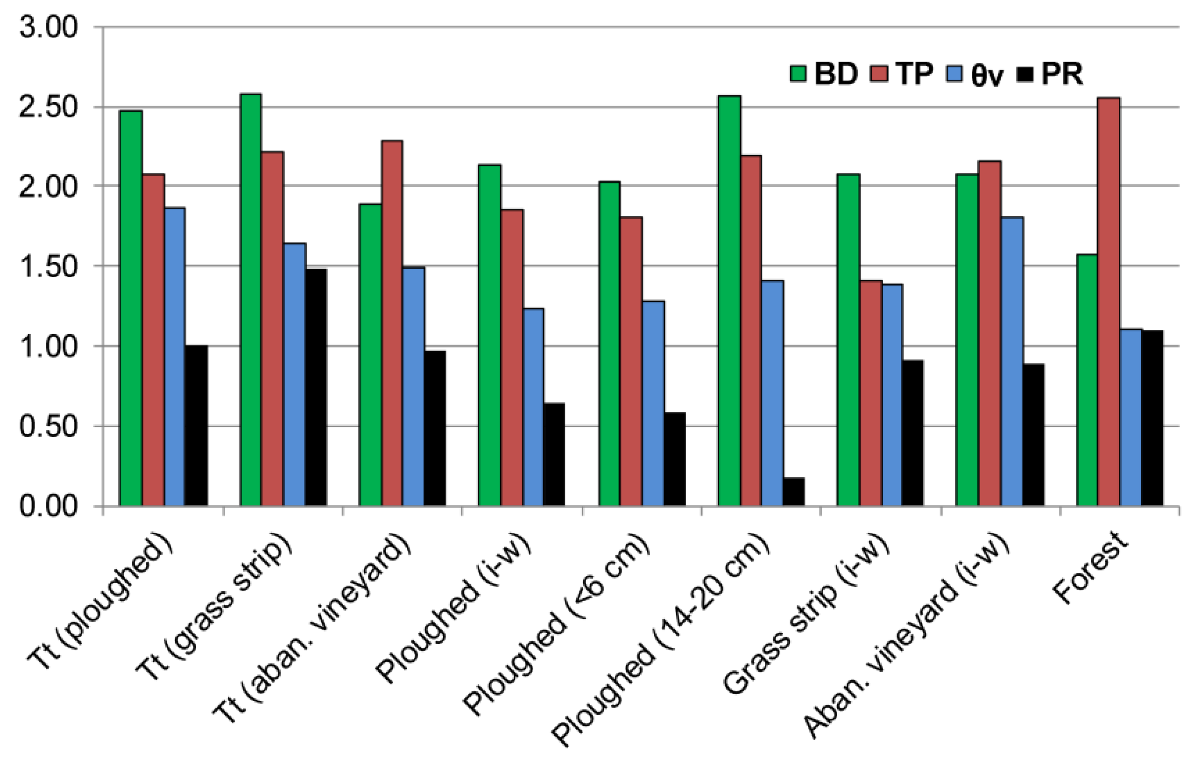
The analysis of the attribute–response relationships in the topsoil in the cultivated and abandoned vineyards and under the forest was performed using Shannon entropy and the IRI. To calculate the entropy, a matrix was created for each soil property. The data size and units of measurement for the four selected properties were different. However, to ensure comparable results, the data were normalized using two methods. Considering that high values of BD and PR are not beneficial for plant growth, the normalized decision matrix was generated by relating the values to the lowest value of the dataset [35] ( N D M i j ) (Equation (1)). A soil characteristic with a higher value can be considered superior and vice versa [36].
N D M i j = q i j M I N q i j
Different from the first two properties, the beneficial response for the TP and θv is given by normalizing with the maximum value of the dataset (Equation (2)). In Equations (1) and (2), M I N q i j and M A X q i j represent the minimum and maximum values of properties q (e.g., BD and TP) with value i at point j.
N D M i j = q i j M A X q i j
The probability was calculated based on the two types of normalizations defined by the following equation:
P r i j = N D M i j i n N D M i j
Shannon entropy [1] was calculated using Equation (4), which considers the probabilities (Pr) associated with various possible states (j) of the soil system at a given point (i). When normalizing the data using the minimum value in the dataset, negative entropy values were obtained, while normalizing with the maximum value yielded positive entropy values. The use of this module was a prerequisite for calculating the entropy weight for each soil property according to the agrotechnics or land use type.
E n = i 1 n | P r i j l o g P r i j |
Entropy weight was calculated using Equation (5), where X1 is the entropy of the first soil property (e.g., TP) and n 4 | E n ( X 1 + X 2 + X 3 + X 4 ) | represents the sum of these entropies (in this study, n = 4). To calculate the entropy weight (Equation (5)), X1 was alternatively replaced with X2, X3, and X4, representing the entropies of the other properties (e.g., BD, θv, and PR). Finally, IRIweight and Enweight favored the evaluation of the weight of each property of a subsystem (e.g., soil on tractor track or ploughed soil) or system (e.g., soil in a forest).
E n w e i g h t = X 1 n 4 | E n ( X 1 + X 2 + X 3 + X 4 ) | × 100
The interquartile ratio index is a simple mathematical expression (Equation (6)) that uses the quartile range as the denominator. The values of the interquartile ratio index were introduced into the formula of resilience to evaluate the dynamics of high stability soil properties as compared to those of the control sample (forest soil). This approach reduced the influence of the extreme values within the dataset [37].
I R I = ln ( Q 2 ( Q 3 Q 1 ) )
High resilience was associated with low system changes and was calculated using Equation (7) [14].
R e s i l i e n c e   ( A , B ) = 1 | A X 1 B X 1 |
In Equation (7), A and B represent two systems or subsystems [14] (Table 1) that are evolving differently, while X1 represents the IRIweight value for a specific physical property (e.g., BD) that is not expressed in percentages.
The IRIweight values are calibrated within the range of 0 to 1. If a change in the system does not affect its complexity (AB = 0), the resilience value is 1. Conversely, if a property is significant perturbed compared to the control system (e.g., soil in a forest), the resilience value will be closer to 0, indicating a greater intensity of perturbation.

3. Results

3.1. Statistical Analysis

Descriptive statistics were calculated for each physical property of the soils for the three systems and subsystems (Table 1). The skewness coefficient empirically verified changes in the mean of the indicator (or process) in the studied area, and values close to zero indicated a stationary process whose mean did not change [38]. Several skewness values greater than 0.5 indicated spatial variability in certain properties (e.g., BD and θv) that were influenced by agrotechnics or soil type properties in the case of the forest (Table 1).
The working hypothesis that the values of the soil properties had a normal distribution (Shapiro–Wilk test) for the three systems (cultivated vineyard, abandoned vineyard, and forest) was rejected (Table 1).
The Tukey–Kramer test explained the differences and similarities between the physical properties of soils resulting from agricultural practices. One advantage of this test is that it can be being applied to an unequal number of samples [39], which was adapted for this study. The inflation of the probability of a type I error increases with the increase in the number of comparisons [40]. Therefore, to mitigate this, the Tukey–Kramer test was conducted on pairs of samples for each soil property. The Tukey–Kramer test revealed similarities in the soil properties between the wheel tracks in the ploughed and grassed rows. Between the wheels, the pairs of ploughed soil–grassed row and grassed row–abandoned vineyard did not suggest differences in terms of the BD, TP, or θv. The test confirmed similarities in the following situations and properties: the BD and TP between the pair of ploughed soil between wheels and the abandoned vineyard; and for the θv and PR, similarities in the wheel track were observed for both the ploughed and abandoned rows.

3.2. Entropy Response

Entropy, which was calculated using Equation (4), is associated with disorder in a system. Less regularity leads to high entropy, while random distribution results in low entropy [5]. Thus, high entropy means that the data are spread out as much as possible, while low entropy means that the data are nearly all concentrated on one value [41]. In general, high entropy corresponds to a high degree of uncertainty, and the soil system will have a low level of organization. Formally speaking, entropy reflects the relationships among soil characteristics for different land use patterns at a given time.
The high entropy observed for the PR suggests that it was the primary property that indicated disorder in the soil system according to the agrotechnics methods used, but the PR was greatly influenced by soil moisture and bulk density (Figure 4). This idea could be accepted for the following succession: ploughed soil between wheels > abandoned soil between wheels > soil under forest vegetation. The other soil properties (BD, TP, and θv) had lower entropy values than the PR but exhibited features depending on the land use (Figure 4). Information theory was used as a measure of “interestingness”, which allowed us to take into consideration the frequency of an occurrence of a rule [41]. The distribution of entropy values for the remaining properties (BD, TP, and θv) allowed the separation of two distinct groups (Figure 4). The first group showed an upward tendency of entropy and encompassed the soil on the tractor track and the ploughed soil between the wheels. The second group displayed symmetry in all three properties and was characteristic of the space between the wheels (abandoned vineyard and grassed strip) as well as the soil beneath forest vegetation (Figure 4). The soil on the tractor track in the abandoned vineyard had values between those two groups.
The interquartile ratio index is an indicator that uses quartiles (Q) to highlight the state of each soil property, while the natural logarithm facilitates the analysis of soil property behavior across different magnitudes and units of measurement. By considering relatively uniform internal characteristics (e.g., texture) and soil forming factors (e.g., relief), the IRI unveils variations in soil physical properties according to land use.
The IRI values obtained for the BD indicated the following sequence: soil in tilled vineyard > soil in abandoned vineyard > soil under forest vegetation. The IRI captured different responses depending on the agricultural practices within the cultivated vineyard. Therefore, after ploughing under wet soil conditions, the IRI showed close values between the tractor track (2.56 and 2.47) and the plough pan at 14–20 cm (2.58) for the BD (Figure 5). Additionally, a favorable dynamic for the BD was observed, as the IRI value for tractor tracks in the abandoned vineyard (1.89) was lower than that for tractor tracks in the cultivated one (2.47 and 2.58).
The hierarchy of the three land use types determined using IRI for the TP was as follows: forest (2.55) > abandoned vineyard > tilled vineyard. The values derived via the IRI from the TP showed a slight decline from the wheel track from the abandoned (2.28) to the cultivated vineyard (2.08, 2.22). For the same property, the indicator highlighted more noticeable discrepancies between the abandoned vineyard (2.16) and the grass strip (1.41) (Figure 5).
The soil moisture and PR showed significant temporal and spatial variability, and the results of this work were similar to those of other researchers [42,43]. The IRI revealed inexplicable differences in the θv, with lower values in the tractor track of the abandoned vineyard (1.50) compared to the tractor track in the cultivated vineyard (1.88 and 1.64). Notably, it was observed that the soil moisture along the tractor track in the abandoned vineyard had different values between the wheels (1.81).
The IRI values that resulted for the PR on the tractor wheel track were determined by the frequency of agricultural machinery traffic and particular activities, such as scarification. After ten years of abandonment, the IRI captured the soil dynamics with a slight decrease in the PR (0.97) along the tractor track compared with the tilled track (1.01 and 1.48). Regarding the space between the wheels, the soil evolution was similar to the previous one, but the IRI value for the abandoned row (0.89) was slightly lower than for the grass strip (0.99) (Figure 5). As expected, the IRI was lowest (0.64) on the ploughed row, but it increased significantly for the soil beneath the forest vegetation due to the presence of tree roots. The IRI discrepancy for the PR between the upper (0–6 cm) and lower (14–20 cm) part of the ploughed horizon was a consequence of the higher moisture at the bottom (Figure 5).
The relationship between the entropy and interquartile ratio index was analyzed via simple linear regression while considering the weight of the two indicators (Enweight and IRIweight) on the tractor track and between the wheels. The pairs examined were BD-TP, TP-θv, and PR-θv. It was found that IRIweight achieved better results than Enweight when considering the grouping of pairs that characterized the soil between the wheels (Table 2).

3.3. Interquartile Ratio Index and Resilience

A system capable of maintaining its complexity after disturbance is considered resilient [14]. Among the four properties examined, resilience was shown only for the BD and TP, which exhibited higher inertia over time compared to the PR and θv. Entropy data were used to calculate resilience, but the results did not yield satisfactory values. The resilience for the BD for the tractor wheels in this instance was higher in the ploughed vineyard–forest soil pair than it was in the abandoned vineyard–forest soil combination under the same conditions.
In Equation (7), A X 1 B X 1 represents the interchangeable properties between the disturbed (D) and control soil (C) (e.g., forest). Thus, the BD expressed through IRIweight exhibited higher values in the disturbed soil (e.g., A X 1 = wheel track) compared to the control soil (forest). Conversely, the TP values were higher in the control soil (e.g., A X 1 = forest) compared to the disturbed soil. The interchangeable nature of the terms in Equation (7) was supported by the inverse correlation between these two properties [44,45].
High resilience is associated with minor changes in data complexity [14]. Integration of IRIweight into resilience analyses enabled the identification of the relationship between soil properties with high stability (PT and BD) for the pair of cultivated soil and soil under forest vegetation. The bulk density usually exhibited a higher resilience than the TP (except for the pair of ploughed soil–soil beneath the forest). In this case, for the BD, the soil in the abandoned vineyard (2011) displayed higher resilience on the tractor track and between the wheels compared to the cultivated vineyard (Figure 6). The ploughing altered the soil complexity, resulting in a reduced resilience of the BD compared to the soil under forest vegetation. Unusually, TP showed lower resilience on the grass strip compared to the control soil. Furthermore, within the ploughed horizon, TP exhibited a “false resilience”, possibly due to soil homogenization resulting from agricultural activities.

4. Discussion

4.1. Entropy and IRI Response to Land Use

In this study, the analysis focused on how the proposed indicator (IRI) and En characterized the condition of (sub)systems according to the selected properties and land use. Furthermore, the study case aimed to integrate the IRI into resilience in order to observe the dynamics of some soil physical properties in the tilled vineyard compared to forest soil. There are several types of entropy [5] applied in soil research, but the interpretation may differ for each type. Soil structure formation is associated with an entropy decrease, while degradation is a dissipative process leading to entropy increase [7]. When the land is abandoned, human activity ceases, and the soil moves to a new state influenced by the biotic component. Porosity responds to environmental changes as organic matter accumulates. Thus, the transition from agricultural land to grassland and deciduous forests in the temperate zone is sustained by an increase in porosity [45]. This change was correctly highlighted by En, which decreased in the soil on the tractor track in the tilled vineyard compared to the soil under the forest vegetation (Figure 4).
Bulk density is assessed to characterize the state of soil compaction in response to land use and soil management practices [46]. Although less evident compared to the TP, the entropy trend for the BD followed the same direction: soil in tilled vineyard > soil under forest. In one of the two cases, the entropy for the BD was lower on the tractor track in the tilled vineyard than in the abandoned one (Figure 4). The information provided by entropy for the BD on the tractor track in the abandoned vineyard seems difficult to explain, but certain models consider that entropy and disorder can have different directions, as order can increase and entropy remains constant [47]. At a higher level of soil organization, entropy is lower; therefore, in the abandoned vineyard between the tractor wheels, the BD should have been lower than in the grassed strip. Considering the polyphasic nature of the soil, it is impossible to assess changes based solely on one property (e.g., BD) alone, and the response time is faster for the liquid phase than for the solid component [48].
The interquartile ratio index was highly effective in distinguishing soil properties with lower temporal variability (e.g., BD and TP) for different land use types, and its results were consistent with previous studies [49]. This research also revealed the highest BD value calculated using the IRI on the wheel track within the tilled vineyard (Figure 4). Additionally, tillage performed with a subsoiler along the tractor track in a grass row resulted in a slight increase in porosity compared to the tractor track in the ploughed row (22.2 and 20.8).
Volumetric moisture, a property characterized by its high spatio-temporal variability, is influenced by several factors. Grasses and shrubs might increase the temporal heterogeneity of soil moisture content compared to the forest at the start of the growing season [50], and the IRI highlights the variability in moisture as a function of land use. The lower soil moisture on the tractor track of the abandoned vineyard as compared to similar conditions in the cultivated vineyard and the soil between the rows raised questions about the accuracy of the results. The removal of trellises from the abandoned vineyard changed the roughness and micromorphology of the terrain through the presence of small excavations that determined the uneven distribution of moisture in the topsoil (Figure 3c). Mathematically, when the second quartile (Q2 = 28) remained constant, the differences could be attributed to the higher values of Q1 (26) and Q3 (31) observed in the wheel track of the tilled compared to the abandoned vineyard (Q1 = 24 and Q3 = 30).
Intensive agriculture practices in vineyards result in soil compaction [51], and penetration resistance is influenced by agrotechnics, with higher values recorded in the wheel track compared with the grassed strip [52]. The results regarding the spatial variation in compaction obtained in this study with the IRI were similar to those reported by other studies [52]. The multitude of PR values included in Q3 and interpreted according to the limits mentioned by other authors [32] was moderate in the wheel track of the cultivated vineyard and low in the abandoned one, indicating a slight improvement in soil compaction. The interquartile ratio index characterized the variation in the physical properties of soils from one land use to another better than the entropy weight.

4.2. Relationships between Soil Physical Characteristics Captured by Entropy and the IRI

Some physical soil characteristics were directly or inversely related. The decrease in porosity in compacted areas was associated with an increase in penetration resistance [53], but the variability in penetration resistance was higher than the bulk density [54]. The coefficient of variation (%) confirmed the larger dispersion of PR values along the wheel track (30.5 in the abandoned vineyard; 26.9 and 22 in the cultivated vineyard) compared to the BD in the tilled vineyard (8 in the abandoned vineyard; 6.9 and 6.2 in the tilled row and grass strip, respectively).
The relationships between soil physical properties presents a certain type of spatiality as a function of agrotechnics, and entropy facilitates the differentiation of symmetric or asymmetric subsystems (Figure 4). Entropy is a measure of complexity, and ploughing can be seen as “adding information” that increases the entropy of some properties [9]. On the wheel track on the cultivated vineyard, some physical properties (TP, BD, and θv) showed a tendency toward symmetry, while on the wheel track on the abandoned vineyard, the properties became asymmetric compared to the former (Figure 4). In “symmetrological terms”, the local order will decrease [55], and the soil properties on the abandoned wheel track will tend to equalize those between the wheels; therefore, entropy may decrease locally [55].
The interquartile ratio index is a dimensionless indicator that accurately highlights the relationship between the physical properties of soils. Consequently, on the wheel track in the tilled vineyard, the IRI registered BD > TP, whereas in the abandoned vineyard, the relation between the two was reversed. It was expected that the TP would have a faster evolution between the wheels than the tractor track in the abandoned vineyard, but a property (e.g., BD) is related to the composition of a defined soil volume while disregarding its internal organization [56]. The soil volume sampled with cylinders revealed the presence of fauna activity (e.g., galleries), plant fragments, and other materials (e.g., plastic and textile materials) originating from specific vineyard practices.
The use of the Shannon index in studies in various domains indicates a decrease in probability as the number of samples is reduced [16]. Decreasing the sample size (15 samples) for the tractor track in the cultivated vineyard confirmed the dependency of the Shannon index on the sample size. When considering the same number of samples (15), the IRI demonstrated greater stability than En (with the exception of the PR on the wheel track in the abandoned vineyard, which fell within the range of values for the tilled vineyard). This difference was explained by the increase in the Q3 value for PR (from 2.6 to 2.9).
The use of the IRI is limited to soil properties that cannot exceed the critical limit for plant development, but it does not apply to soil pollution, where this threshold can be surpassed.

4.3. Resilience Response to IRI Values

There is no universally accepted index for experimentally evaluating and quantifying soil resilience [57]. To compare an undisturbed control soil sample with disturbed soil samples, various mathematical formulae can be used, such as ratios [11], differences [14], or more complex equations [13]. Resilience is assessed only for soil properties that exhibit high stability over time (e.g., BD and TP). IRIweight values for the BD and TP (without being expressed as a percentage) are included in the resilience formula used by Ginebreda et al. [14] (Equation (7)). In this situation, the control soil was associated with forest vegetation, and the disturbed soil corresponded to the tilled and abandoned vineyards.
Forest ecosystems are considered to have a higher degree of self-organization among all ecosystems [58]; therefore, some soil properties (BD and TP) will be different from those characteristic of anthropized ecosystems. The disturbed soil on wheel-tracked and tilled soil between wheels showed lower resilience for both physical characteristics than the soil in the abandoned track (Figure 6). Regarding the TP, the decrease in resilience in the grass strip compared to the control soil was a consequence of foot traffic for certain activities (vineyard cleaning and grape picking). Also, the fact that the TP values characterized the soil state at the sampling depth (<6 cm) should be taken into account.
Some studies confirmed a decrease in the BD in a short time (7 years) in grassed soil compared to ploughed soil [59]. In the abandoned vineyard and in the grass strip, the BD showed a higher ability to advance to the dynamic equilibrium state of the forest soil.

5. Conclusions

The interquartile ratio index (IRI) is a newly proposed indicator that evaluates soil properties (especially physical ones) in marginal environmental conditions. In this context, it was applied to three land uses, i.e., a tilled vineyard, an abandoned vineyard, and forested vegetation. The indicator was tested for four topsoil (<25 cm) physical properties (BD, TP, θv, PR) along a wheel track/between the wheels and in natural conditions for the forested vegetation.
  • The Tukey–Kramer test applied to the different soils uses did not accurately match the differences for some soil physical properties (e.g., TP). Entropy is associated with disorder in a system, and in this study, it was suggested that the PR was the primary property that indicated disorder in the soil system. Furthermore, the PR was highly influenced by the agrotechnics methods used but also by the soil moisture and density.
  • The interquartile ratio index ranks soil characteristics based on land use and, unlike entropy, accurately presents the relationships between soil physical properties. The comparative analysis between the IRI and entropy indices evidenced the higher stability of the former when changing the size of the data string. The natural logarithm allowed us to compare soil properties having different sizes and measurement units, while quartiles mitigated the influence of extreme values on the results. The elimination of extreme values limits the application of the indicator in the case of studies in which these values become important (e.g., geochemical studies).
  • The IRI expresses the state of the soil system based on the physical properties of the soil at a given time. The control soil was associated with forest vegetation, and the disturbed soil corresponded to the tilled vineyard. Resilience was calculated only for properties with a higher spatio-temporal stability (TP and BD). The results indicated higher resilience of the soil in the abandoned vineyard compared to the tilled one both along the wheel track and between the wheels for both physical properties. The TP was less resilient in the wheel gap for the ploughed soil–forest pair versus the grass strip–forest pair.

Author Contributions

Conceptualization, I.V.; Methodology, C.V.S. and D.C.L.; Software, C.V.S.; Validation, D.C.L., I.V. and G.Z.; Formal analysis, G.Z. and A.N.; Investigation, D.C.L.; Resources, I.V., G.Z., A.N. and L.C.A.; Data curation, C.V.S., D.C.L., G.Z. and L.C.A.; Writing—original draft, C.V.S.; Writing—review & editing, I.V.; Funding acquisition, D.C.L. All authors have read and agreed to the published version of the manuscript.

Funding

This research was funded by the Department of Geography, Faculty of Geography & Geology, “Alexandru Ioan Cuza” University of Iasi (Internal Research Program No. 1/2021).

Data Availability Statement

Not applicable.

Acknowledgments

Acknowledgement is given to the Operational Program Competitiveness 2014–2020, Axis 1, under POC/448/1/1 research infrastructure projects for public R&D institutions/Sections F 2018 through the Research Center with Integrated Techniques for Atmospheric Aerosol Investigation in Romania (RECENT AIR) project under grant agreement MySMIS No. 127324.

Conflicts of Interest

The authors declare no conflict of interest. The funders had no role in the design of the study; in the collection, analyses, or interpretation of data; in the writing of the manuscript; or in the decision to publish the results.

References

  1. Shannon, C.E. A Mathematical Theory of Communication. Bell Syst. Tech. J. 1948, 27, 379–423. [Google Scholar] [CrossRef]
  2. Rey, J.-M.; Montero, E.; Martín, M.A. Inter-Scale Behavior of Balanced Entropy for Soil Texture. Geoderma 2006, 134, 415–427. [Google Scholar] [CrossRef]
  3. de Oliveira, J.A.T.; Pires, L.F.; Cássaro, F.A.M.; Gaspareto, J.V.; Posadas, A.N.D.; Mooney, S.J. Soil Pore System Complexity and Heterogeneity as Affected by Contrasting Management Practices. Soil Tillage Res. 2022, 224, 105497. [Google Scholar] [CrossRef]
  4. Chun, H.C.; Giménez, D.; Yoon, S.W. Morphology, Lacunarity and Entropy of Intra-Aggregate Pores: Aggregate Size and Soil Management Effects. Geoderma 2008, 146, 83–93. [Google Scholar] [CrossRef]
  5. Howedi, A.; Lotfi, A.; Pourabdollah, A. An Entropy-Based Approach for Anomaly Detection in Activities of Daily Living in the Presence of a Visitor. Entropy 2020, 22, 845. [Google Scholar] [CrossRef] [PubMed]
  6. Toomanian, N.; Jalalian, A.; Khademi, H.; Eghbal, M.K.; Papritz, A. Pedodiversity and Pedogenesis in Zayandeh-Rud Valley, Central Iran. Geomorphology 2006, 81, 376–393. [Google Scholar] [CrossRef]
  7. Addiscott, T.M. Entropy and Sustainability. Eur. J. Soil Sci. 1995, 46, 161–168. [Google Scholar] [CrossRef]
  8. Martín, M.Á.; Reyes, M.; Taguas, F.J. Estimating Soil Bulk Density with Information Metrics of Soil Texture. Geoderma 2017, 287, 66–70. [Google Scholar] [CrossRef]
  9. Klöffel, T.; Jarvis, N.; Yoon, S.W.; Barron, J.; Giménez, D. Relative Entropy as an Index of Soil Structure. Eur. J. Soil Sci. 2022, 73, e13254. [Google Scholar] [CrossRef]
  10. Blanco-Canqui, H.; Lal, R. Soil Resilience and Conservation. In Principles of Soil Conservation and Management; Springer: Dordrecht, The Netherlands, 2008; pp. 425–447. [Google Scholar]
  11. Seybold, C.A.; Herrick, J.E.; Brejda, J.J. Soil Resilience: A Fundamental Component of Soil Quality. Soil Sci. 1999, 164, 224–234. [Google Scholar] [CrossRef]
  12. de Andrade Bonetti, J.; Anghinoni, I.; de Moraes, M.T.; Fink, J.R. Resilience of Soils with Different Texture, Mineralogy and Organic Matter under Long-Term Conservation Systems. Soil Tillage Res. 2017, 174, 104–112. [Google Scholar] [CrossRef]
  13. Orwin, K.H.; Wardle, D.A. New Indices for Quantifying the Resistance and Resilience of Soil Biota to Exogenous Disturbances. Soil Biol. Biochem. 2004, 36, 1907–1912. [Google Scholar] [CrossRef]
  14. Ginebreda, A.; Sabater-Liesa, L.; Barceló, D. Quantification of Ecological Complexity and Resilience from Multivariate Biological Metrics Datasets Using Singular Value Decomposition Entropy. MethodsX 2019, 6, 1668–1676. [Google Scholar] [CrossRef] [PubMed]
  15. Ludwig, M.; Wilmes, P.; Schrader, S. Measuring Soil Sustainability via Soil Resilience. Sci. Total Environ. 2018, 626, 1484–1493. [Google Scholar] [CrossRef] [PubMed]
  16. Konopiński, M.K. Shannon Diversity Index: A Call to Replace the Original Shannon’s Formula with Unbiased Estimator in the Population Genetics Studies. PeerJ 2020, 8, e9391. [Google Scholar] [CrossRef] [PubMed]
  17. Baican, V. Geography of Moldavia Reflected in Cartographic Documentd of 18th Century; Romanian Academy Press: Bucharest, Romania, 1996; p. 167. [Google Scholar]
  18. Stanga, I.C.; Niacsu, L. Using Old Maps and Soil Properties to Reconstruct the Forest Spatial Pattern in the Late 18th Century. Environ. Eng. Manag. J. 2016, 15, 1369–1378. [Google Scholar]
  19. Chifu, T.; Sarbu, I.; Stefan, N. Phytocoenoses of the order Quercetalia pubescentis Br-Bl 1931em Soo 1964 on the territory of Moldavia (Romania). Bull. Bot. Gard. Anastasie Fatu Iasi 2004, 12, 17–34. [Google Scholar]
  20. Lupascu, A.; Onofrei, M. Objects Regarding the Forest Stock in Iasi County with Special Regards towards Silvic Wards in Podu Iloaiei, Harlau and Pascani. Present Environ. Sustain. Dev. UAIC 2010, 4, 189–197. [Google Scholar]
  21. Ursu, A.; Ungureanu, O.A.; Istrate, V.; Acuculitei, A.; Buciumanu, A. The Forest Area Change in the Prut River Wathershed (Romania). In Cartography and GIS; Surveying Geology & Mining Ecology Management (SGEM): Albena, Bulgaria, 2015; Volume 2, pp. 1131–1138. [Google Scholar]
  22. WRB. World Reference Base for Soil Resources 2014, International Soil Classification System for Naming Soils and Creating Legend for Soil Map; FAO: Rome, Italy, 2014. [Google Scholar]
  23. Ditzer, C.; Scheffe, K.; Monger, H.C. Soil Science Division Staff. 2017. Soil Survey Manual; USDA Handbook 18; Government Printing Office: Washington, DC, USA, 2017. [Google Scholar]
  24. Jitareanu, G.; Rusu, C.; Moca, V.; Filipov, F.; Vasiliniuc, I. In Proceedings of the 19th National Soil Science Conference, Iasi, Romania, 23–29 August 2009; Ion Ionescu de la Brad University Press: Iasi, Romania, 2009; Volume 2. [Google Scholar]
  25. Clarke Topp, G.; Ferre, P.A. The Soil Solution Phase. In Methods of Soil Analysis; SSSA: 5; Soil Science Society of America: Madison, WI, USA, 2002; Volume 4—Physical Methods, pp. 417–474. [Google Scholar]
  26. McKenzie, N.; Coughlan, K.; Cresswell, H. Soil Physical Measurement and Interpretation for Land Evaluation; CSIRO Publishing: Clayton, Australia, 2002; p. 379. [Google Scholar]
  27. Eijkelkamp Agrisearch Equipment. Air Pycnometer According to Langer. Manual. 2014. Available online: www.eijkelkamp.com (accessed on 29 July 2022).
  28. Skopp, J.M. Physical Properties of Primary Particles. In Soil Physics Companion; CRC Press: Boca Raton, FL, USA, 2002; pp. 1–15. [Google Scholar]
  29. Flint, A.L.; Flint, L.E. Particle Density. In Methods of Soil Analysis; SSSA: 5; Soil Science Society of America: Madison, WI, USA, 2002; Volume 4—Physical Methods, pp. 229–240. [Google Scholar]
  30. Royal Eijkelkamp. Penetrolloger. User Manual. 2022. Available online: https://www.royaleijkelkamp.com/media/nrwjyah3/m-0615sae-penetrologger.pdf (accessed on 29 July 2022).
  31. Kuang, B.; Mahmood, H.S.; Quraishi, M.Z.; Hoogmoed, W.B.; Mouazen, A.M.; van Henten, E.J. Sensing Soil Properties in the Laboratory, in Situ, and on-Line: A Review. In Advances in Agronomy; Elsevier: Amsterdam, The Netherlands, 2012; Volume 114. [Google Scholar]
  32. Canarache, A. PENETR—A Generalized Semi-Empirical Model Estimating Soil Resistance to Penetration. Soil Tillage Res. 2012, 16, 51–70. [Google Scholar] [CrossRef]
  33. Blum, A. What Can Be Learned from a Comaprison of Two Agricultural Knowledge Systems ? The Case of the Neterlands and Istrael. Agric. Ecosyst. Environ. 1991, 33, 325–339. [Google Scholar] [CrossRef]
  34. Rogerson, P.A. Statistical Methods for Geography; Sage: Newbury Park, CA, USA, 2016. [Google Scholar]
  35. Kumar, R.; Singh, S.; Bilga, P.S.; Singh, J.J.; Singh, S.; Scurtu, M.L.; Pruncu, C.I. Revealing the Benefits of Entropy Weights Method for Multi-Objective Optimization in Machining Operations: A Critical Review. J. Mater. Res. Technol. 2021, 10, 1471–1492. [Google Scholar] [CrossRef]
  36. Su, H.; Zhu, C. Application of Entropy Weight Coefficient Method in Evaluation of Soil Fertility. In Recent Advances in Computer Science and Information Engineering; Qian, Z., Cao, L., Su, W., Wang, T., Yang, H., Eds.; Lecture Notes in Electrical Engineering; Springer: Berlin/Heidelberg, Germany, 2012; Volume 126, pp. 697–703. [Google Scholar] [CrossRef]
  37. Jambu, M. Exploratory and Multivariate Data Analysis, 1st ed.; Elsevier: Amsterdam, The Netherlands, 1991. [Google Scholar]
  38. Cortés-D, D.L.; Camacho-Tamayo, J.H.; Giraldo, R. Spatial Prediction of Soil Penetration Resistance Using Functional Geostatistics. Sci. Agric. 2016, 73, 455–461. [Google Scholar] [CrossRef]
  39. Midway, S.; Robertson, M.; Flinn, S.; Kaller, M. Comparing Multiple Comparisons: Practical Guidance for Choosing the Best Multiple Comparisons Test. PeerJ 2020, 8, e10387. [Google Scholar] [CrossRef] [PubMed]
  40. Lee, S.; Lee, D.K. What Is the Proper Way to Apply the Multiple Comparison Test? Korean J. Anesthesiol. 2018, 71, 353–360. [Google Scholar] [CrossRef] [PubMed]
  41. McClean, S.I. Data Mining and Knowledge Discovery. In Encyclopedia of Physical Science and Technology; Elsevier: Amsterdam, The Netherlands, 2003; pp. 229–246. [Google Scholar] [CrossRef]
  42. Lagacherie, P.; Coulouma, G.; Ariagno, P.; Virat, P.; Boizard, H.; Richard, G. Spatial Variability of Soil Compaction over a Vineyard Region in Relation with Soils and Cultivation Operations. Geoderma 2006, 134, 207–216. [Google Scholar] [CrossRef]
  43. Melendres, A.I.; Zermeño, A.; Ramírez, H.; Cárdenas, J.O.; Cadena, M. Eficiencia Del Uso Del Agua de Un Viñedo y Su Relación Con Porosidad Del Suelo. Tecnol. Cienc. Agua 2017, 8, 57–69. [Google Scholar] [CrossRef]
  44. Hrčková, K.; Žák, Š.; Hašana, R.; Švančárková, M. Change of Chosen Soil Physical Properties of Chernozem after Seven Years of No-Till Soil Cultivation. J. Cent. Eur. Agric. 2014, 15, 254–262. [Google Scholar] [CrossRef]
  45. Robinson, D.A.; Thomas, A.; Reinsch, S.; Lebron, I.; Feeney, C.J.; Maskell, L.C.; Wood, C.M.; Seaton, F.M.; Emmett, B.A.; Cosby, B.J. Analytical Modelling of Soil Porosity and Bulk Density across the Soil Organic Matter and Land-Use Continuum. Sci. Rep. 2022, 12, 7085. [Google Scholar] [CrossRef] [PubMed]
  46. Hakansson, I.; Lipiec, J. A Review of the Usefulness of Relative Bulk Density Values in Studies of Soil Structure and Compaction. Soil Tillage Res. 2000, 53, 71–85. [Google Scholar] [CrossRef]
  47. Landsberg, P.T. Can Entropy and Order Increase Together? Phys. Lett. 1984, 102A, 171–173. [Google Scholar] [CrossRef]
  48. Lin, H. Three Principles of Soil Change and Pedogenesis in Time and Space. Soil Sci. Soc. Am. J. 2011, 75, 2049–2070. [Google Scholar] [CrossRef]
  49. Hendgen, M.; Döring, J.; Stöhrer, V.; Schulze, F.; Lehnart, R.; Kauer, R. Spatial Differentiation of Physical and Chemical Soil Parameters under Integrated, Organic, and Biodynamic Viticulture. Plants 2020, 9, 1361. [Google Scholar] [CrossRef] [PubMed]
  50. James, S.E.; Pärtel, M.; Wilson, S.D.; Peltzer, D.A. Temporal Heterogeneity of Soil Moisture in Grassland and Forest. J. Ecol. 2003, 91, 234–239. [Google Scholar] [CrossRef]
  51. Bogunovic, I.; Viduka, A.; Magdic, I.; Telak, L.J.; Francos, M.; Pereira, P. Agricultural and Forest Land-Use Impact on Soil Properties in Zagreb Periurban Area (Croatia). Agronomy 2020, 10, 1331. [Google Scholar] [CrossRef]
  52. Burg, P.; Zemanek, P.; Turan, J.; Findura, P. The Penetration Resistance as a Soil Degradation Indicator in the Viticulture. Acta Univ. Agric. Silvic. Mendel. Brun. 2012, 40, 29–36. [Google Scholar]
  53. Pagliai, M.; Vignozzi, N. The Soil Pore System as an Indicator of Soil Quality. Adv. GeoEcology 2002, 35, 69–80. [Google Scholar]
  54. Ferrero, A.; Usowicz, B.; Lipiec, J. Effects of Tractor Traffic on Spatial Variability of Soil Strength and Water Content in Grass Covered and Cultivated Sloping Vineyard. Soil Tillage Res. 2005, 84, 127–138. [Google Scholar] [CrossRef]
  55. Darvas, G. Symmetry, Order, Entropy and Information. 2005. Available online: http://www.mdpi.org/fis2005/F.15.paper.pdf (accessed on 3 May 2023).
  56. Reichert, J.M.; da Rosa, V.T.; Vogelmann, E.S.; da Rosa, D.P.; Horn, R.; Reinert, D.J.; Sattler, A.; Denardin, J.E. Conceptual Framework for Capacity and Intensity Physical Soil Properties Affected by Short and Long-Term (14 Years) Continuous No-Tillage and Controlled Traffic. Soil Tillage Res. 2016, 158, 123–136. [Google Scholar] [CrossRef]
  57. Yi, C.; Jackson, N. A Review of Measuring Ecosystem Resilience to Disturbance. Environ. Res. Lett. 2021, 16, 053008. [Google Scholar] [CrossRef]
  58. Li, B.-L. Why Is the Holistic Approach Becoming so Important in Landscape Ecology? Landsc. Urban Plan. 2000, 50, 27–41. [Google Scholar] [CrossRef]
  59. Capó-Bauçà, S.; Marqués, A.; Llopis-Vidal, N.; Bota, J.; Baraza, E. Long-Term Establishment of Natural Green Cover Provides Agroecosystem Services by Improving Soil Quality in a Mediterranean Vineyard. Ecol. Eng. 2019, 127, 285–291. [Google Scholar] [CrossRef]
Figure 1. Soil sampling in the study area (a—the position of the study area in Romania, b—the sampling grid).
Land 12 01750 g001
Figure 2. Soil surface temperature (T°) and precipitations (pp) in June 2021.
Land 12 01750 g002
Figure 3. Sampling in the cultivated vineyard (a,b), the abandoned vineyard (c), and the forest (d), (bullets and numbers indicate the sampling points) (June 2021).
Land 12 01750 g003
Figure 4. Entropy for soil properties (Tt, tractor track; i-w, space between the wheels; BD, bulk density; TP, total porosity; θv, volumetric moisture; PR, penetration resistance).
Land 12 01750 g004
Figure 5. Interquartile report index for soil properties (Tt, tractor track; i-w, space between the wheels; BD, bulk density; TP, total porosity; θv, volumetric moisture; PR, penetration resistance).
Land 12 01750 g005
Figure 6. Resilience for BD and TP (Tt, tractor track; i-w, space between the wheels; BD, bulk density; TP, total porosity; D, disturbed soil; C, control soil).
Land 12 01750 g006
Table 1. Statistical data for the BD, TP, θv, and PR for each system and subsystem.
S *Ss ** 1Ss ** 2IndicatorNo. of SamplesMinMaxAverageStDEVSkewShapiro–Wilk
Worked vineyardPlow rowWheel markBD401.231.771.510.1−0.450.12
TP40315444.24.75−0.050.32
θv4021.2736.829.983.5−0.070.96
PR401.13.82.10.580.580.58
Between the wheels
(0–6 cm)
BD270.951.521.220.130.330.72
TP27427054.87.14−0.130.4
θv2719.7837.1327.244.80.410.32
PR270.32.20.90.440.880.09
Between the wheels
(14–20 cm)
BD131.11.491.290.080.010.35
TP13426052.694.67−0.90.39
θv1324.141.934.185.1−0.120.73
Grassed rowWheel markBD181.251.661.470.09−0.150.78
TP18385445.54.310.310.28
θv1822.3938.6630.794.390.250.39
PR1823.82.40.541.74*
Grass stripBD181.091.541.290.140.210.24
TP18426352.836.93−0.410.08
θv1822.9837.1330.614.52−0.290.32
PR180.92.21.30.360.590.31
Abandoned vineyardvine and spontaneous vegetationWheel markBD301.041.381.210.090.210.1
TP30405848.233.93−0.10.28
θv302035.1527.794.05−0.280.55
PR301.13.41.90.580.760.37
Between the wheelsBD301.011.41.260.1−0.910.09
TP30466152.44.020.630.14
θv3021.6341.4832.44.78−0.590.15
PR300.94.61.90.941.59*
ForestBD380.781.980.940.110.670.04
TP38546862.443.57−0.70.02
θv3815.9931.6824.354.68−0.160.04
PR381.24.12.50.70.030.49
S * = system, Ss ** = subsystem, * = values < 0.01, BD = g·cm−3, TP = %, θv = %, PR = MPa.
Table 2. R-values for IRIweight and Enweight.
IndicesBD-TPTP-θvPR-θv
IRIweight for tractor track0.990.110.9
Enweight for tractor track0.390.90.9
IRIweight between the wheels0.980.770.89
Enweight between the wheels0.950.090.34
Disclaimer/Publisher’s Note: The statements, opinions and data contained in all publications are solely those of the individual author(s) and contributor(s) and not of MDPI and/or the editor(s). MDPI and/or the editor(s) disclaim responsibility for any injury to people or property resulting from any ideas, methods, instructions or products referred to in the content.

