


The Midway Plaisance, which stretches for a mile between Jackson Park and Washington Park, often puzzles people. Is it a road? Is it a park? What’s a plaisance?
The answer starts in 1853, when Paul Cornell gave the Illinois Central Railroad right of way across his lakefront land in exchange for a passenger stop at 53rd Street. Then, in 1869, he organized the South Parks Commission to connect his land to the city in the north via a series of boulevards and parks. Having seen the positive effect that New York City’s Central Park had on real estate, the commission hired Central Park’s designer Frederick Law Olmsted to do the same in Chicago. Unfortunately, Cornell’s two projects, the railroad and the park master plan, clashed.
In 1869, Olmsted gazed in dismay at the 1,000 acres of sand, scrub oaks and swales. Luckily, Lake Michigan was there to inspire him. Flat wetland could become flat water, ideal for rowboats and canoes. He decided he could unify the space with a network of lagoons and ponds leading to Lake Michigan. The French already had a term for a park built for pleasure boating, so Olmsted used it. In the western area, he labeled a section “Upper Plaisance.” In the eastern area, he had a “Lagoon Plaisance.” Connecting the two was a “Midway Plaisance.” In other words, Midway Plaisance wasn’t a name. It was a description.

A map reproduction of Olmsted and Vaux first plan for the South Parks, 1871.
In Central Park, Olmsted had buried the cross streets below grade to preserve his vistas. He thought people living in narrow city streets needed the uplift of seeing into the distance. With the canal, the streets had to go overhead. A series of bridges might also carry the eye into the distance.
Just months after the plan’s unveiling, the 1871 fire destroyed the South Park Commission’s offices and all its financial records, which hampered its ability to acquire land. In 1872, the commission hired landscaper Horace Cleveland to start work on the areas that were available. By 1881, Drexel Boulevard, much of the western section, and the northern tip of the eastern section were landscaped with the ornamental horticulture that Olmsted strongly disliked. The commission decided to give the landscaped areas separate names--Washington Park in the west and Jackson Park in the east. No one thought to name the undeveloped dirt road that wound between them.
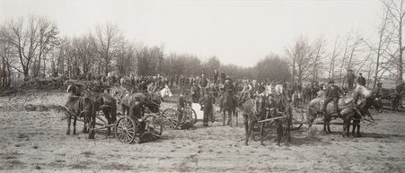
In 1891, the commission handed Jackson Park and the Midway over to the World’s Columbian Exposition. The main fair buildings were in Jackson Park, where the swales were dug out to form deep lagoons and the soil piled up to form dry land. The Midway was for the concessions, which, like the Ferris Wheel, charged an extra fee and made a profit for the fair. To pack in as many as possible, they simply leveled the whole mile from Stony Island to Cottage Grove. Unfortunately, leveling didn’t solve the water problem. Beneath the Midway’s sand there’s a layer of impermeable clay. Water has nowhere to go. As a result, a nickname for the central promenade during the fair was the “Mudway Nuisance.”

Construction of the Midway Plaisance, World's Columbian Exposition, March 24, 1892.
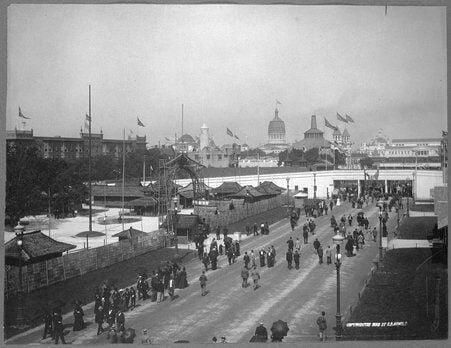
A wooden wall sealed off the Midway along 59th and 60th streets. Stony Island, Dorchester and Woodlawn avenues crossed on temporary bridges, and the Illinois Central Railroad raised its tracks from 51st to 67th streets. That way, one general admission gave access to the whole fairground. People strolled under the bridges from the quiet, awe-inspiring White City to the raucous Midway. “Midway” became synonymous with the fun section of fairs.

View of the Midway Plaisance at the World's Columbian Exposition world's fair, 1893.
On January 1, 1894, the parks returned to the South Parks Commission. As they cleared the rubble, they turned again to Olmsted, now joined by his son and Charles Eliot. Once more, the Olmsteds tried to unify the experience of the parks with pleasure boats. The new design for the Midway, however, was a formal grid. The first plan varied the shape and size of the ponds down the length of the Midway. The second plan called for identical rectangular 8-foot-deep basins, 1300 feet long and 100 feet wide, lined with straight stone walls, crossed by five identical stone bridges. Vase-shaped elms would form mile-long alleés over the carriageways. The Tribune raved that the finished product would “astound Venetians and the habitués of the Bois.”
Work started in the fall of 1894. They built a boathouse next to the circular boat basin in Jackson Park that would lead to the canal. Workmen dug the boat basin and the central Midway panels down three feet. They planned to dig the next five feet in 1895, after a few problems were solved.
The first problem was water. With the fluctuations of Lake Michigan and the difference in elevations, the canal might drain the Washington Park Mere by as much as six feet. Locks were an obvious solution but expensive and annoying to paddlers. The second problem was the railroad right of way. Apparently, no one had discussed the new plan with Illinois Central. The railroad pointed out that the commission had asked for two 60-foot openings for the carriageways and side streets. Now the commission wanted to add an unsupported span of 100 feet over water? Who was going to pay for all that extra structural steel? Not the railroad! The commission couldn’t force the railroad because the right of way predated the commission. The third problem was money. Enough money could have solved the first two problems, but the nation was in a depression and the commission had other priorities.
While the plan stalled, the streets filled in. The Gothic wall of the University of Chicago slowly formed along 59th Street, and elegant apartment buildings appeared along 60th Street. In 1906, Lorado Taft moved his studio into a barn at 60th Street and Ellis Avenue. As he walked along the Midway, his imagination took flight.
On the east Taft imagined a towering Fountain of Creation, with waterfalls cascading into the lagoon. It would face the Fountain of Time on the western end. The Bridge of Science would carry Dorchester. The Bridge of Religion would carry Ellis. In the center, carrying Woodlawn, would be the largest Bridge of all—the Arts. A hundred statues of great men, 10-foot-tall on 8-foot pedestals, would march along the side panels, fifty on a side.

The architects Irving and Allen Pond designed this prototype of the Bridge of the Arts for Lorado Taft’s Plan for the Midway, 1909.
Taft enlisted his friends and colleagues to contribute to the models. In 1910, Taft unveiled his vision. The Inter Ocean reporter marveled at “the dream in marble” while the poet Harriet Monroe exclaimed in the Tribune that “if we have a sculptor who can dream such things, we should fulfill his dreams.” In interviews, Taft referred to the connecting water as a “wide lagoon,” probably because the railroad had filled in its embankment in 1908. Still, as late as 1913, the South Parks Commission seemed to have thought a canal was possible when it refused permission to the Chicago Street Railway to lay tracks on Stony Island between 59th and 60th. Perhaps their optimism had risen because the Ferguson Fund had just funded a full-size model of the Fountain of Time, all 126 feet of it.
World War I and technical difficulties slowed progress on the Fountain of Time. By the time the war was over, enthusiasm for grand Beaux Art projects had waned. In 1918, the railroad finished off its Midway viaducts with new steel and ornamental balustrades. The dream of a plaisance, however, was not over. Laverne Noyes, who built a women’s center on 59th Street in honor of his late wife Ida, decided to rethink the Midway with the help of landscape architect O. C. Simonds. Their plan featured winding paths around a chain of irregular woodland lakes from 200 to 400 feet wide that connected to Washington Park. An inlet led into the basement of Ida Noyes Hall so the women could clamber into their canoes without revealing any unmentionables. Laverne Noyes had the kind of money to make big projects happen, but he died in 1919 and the plan died with him.
Taft finally completed the Fountain of Time in 1922. He hadn’t given up hope for the Fountain of Creation. Its full-scale figures filled the Midway Studios when he died in 1936. Unfortunately, they weren’t saved. Eventually, the statue dedicated to Masaryk took its place.
In 1934, the South Parks Commission dissolved, and the Chicago Park District took over. The idea of unifying the experience of the three parks was gone. May E. McAdams, a Park District landscape designer, turned the unfinished boat basin in Jackson Park into the Perennial Garden, later known as the Women’s Garden. No such plans were made to repurpose the Midway’s sunken panels. In the winter, the panels were flooded and used by thousands of skaters. In the summer, they were muddy playing fields. The carriageways were widened into fast roadways, lined with the parked cars of university employees.
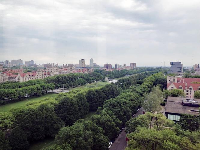
In 1931, the university had edged south of the Midway to the land that John D. Rockefeller had given it in 1907, but it wasn’t until after World War II that the expansion along 60th Street took off. The university replaced the apartment buildings with striking modernist architecture. Fewer and fewer people lived on the Midway. There was even a proposal to seal off the roads and turn it into a university quadrangle. Around 1980, Dutch Elm disease wiped out the signature trees. Winters became too warm to flood the sunken panels for ice skating. The Midway became a deserted afterthought, especially after dark.

The Midway Crossings light bridges.
In 2000, the university and the Park District produced a new master plan. It called for the return of skating via the refrigerated ice rink. Side panels near the Linné statue and Burton-Judson dorm became winter gardens. Then, between 2010 and 2013, the Midway Crossings redefined the length of the park. Broad overhanging sidewalks create the feeling of bridges floating over the sunken panels at Dorchester, Woodlawn, and Ellis Avenues. Large xeriscaped planters provide color and butterfly habitat. The illuminated 40-foot steel masts and guideposts light up the darkness.
It took 130 years, but Olmsted’s series of bridges uplifting the spirit by pulling the eye into the distance, are finally part of the Midway, though the Midway never did become a plaisance.
If you see something around Hyde Park that makes you ask, "What’s that about?", let me know at hydeparkquestions@gmail.com. I might be able to find the story.

(2) comments
Thanks for explaining what Plaisance means. Using any part of the eastbound Midway to "pay back" for the OPC give-away is a shame.
This is fantastic. Thank you!
Welcome to the discussion.
Log In
Keep it Clean. Please avoid obscene, vulgar, lewd, racist or sexually-oriented language.
PLEASE TURN OFF YOUR CAPS LOCK.
Don't Threaten. Threats of harming another person will not be tolerated.
Be Truthful. Don't knowingly lie about anyone or anything.
Be Nice. No racism, sexism or any sort of -ism that is degrading to another person.
Be Proactive. Use the 'Report' link on each comment to let us know of abusive posts.
Share with Us. We'd love to hear eyewitness accounts, the history behind an article.