The Mississippi Is Losing Its Fight With the Ocean
A combination of drought and sea-level rise has sent a wedge of salt water moving up the river.
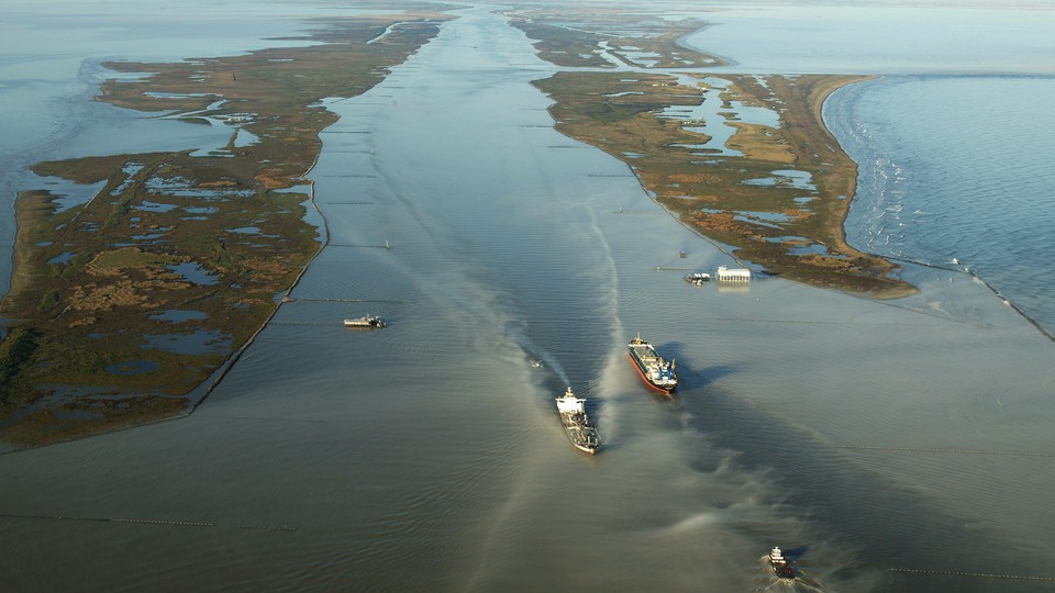
The mouth of the Mississippi River is the arena for a kind of wrestling match. In one corner of the ring is the salt water of the Gulf of Mexico, and in the other, the river’s fresh water. The two shove against each other, and usually, the Mississippi flows with enough force to keep the salt water out. But this year’s drought, currently affecting 40 percent of the continental United States, sapped the Mississippi of water pressure, and a wedge of salt water began muscling its way upstream along the riverbed this summer. It’s already corrupted the drinking water in several towns in southeast Louisiana, and could reach New Orleans around late November. The ocean is winning.
Whatever the climate brings in a year, the Mississippi River keeps the score. This year’s saltwater intrusion “is the integration of all these environmental events that have happened throughout the Great Plains, throughout the Ohio Valley, throughout parts of the Mountain West,” Matthew Hiatt, a hydrologist at Louisiana State University, told me. Landside drought lowers the river’s water levels, and rising sea levels on the ocean side pushes salt water in. Those who study the Mississippi agree that this year’s saltwater intrusion is a particularly dramatic example of what may become a more frequent feature of the dry season. “This is not a one-off or once-in-100-years thing,” William McAnally, hydraulic-engineering professor emeritus at Mississippi State University, told me. “It’s something we’re going to be seeing rather often.”
This isn’t the first time it’s happened. During the Dust Bowl, New Orleans’ drinking water had a salt concentration 55 percent above current federal guidelines. And in 1988—a year so hot and dry that about 30 percent of the nation’s corn crop failed and wildfires raged in Yellowstone for months—a wedge of seawater stopped just short of the water-intake plant for the eastern bank of Orleans Parish. In the past few decades, salt water has traveled far enough upriver that the United States Army Corps of Engineers built semi-temporary underwater earthen dams, or sills, four different times to stop it—in 1988, 1999, 2012, and last year. This year and 2022 mark the first consecutive times the Army has had to do so.
Human activity is also directly clearing the path for salt water. Throughout the Mississippi’s history, engineers have lowered its southernmost riverbed to accommodate the ships that fuel the region’s economy. The Army Corps of Engineers last lowered the channel in 1987, to 45 feet below the water line, and has begun deepening it to 50. Any drop “essentially provides more space for salt water to move in when the water levels are low,” Hiatt told me.
These compounding factors—lowering the river’s navigational depth, sea-level rise, and changing rainfall patterns—are a formula for more frequent saltwater intrusion, he said. In general, you can think of the Mississippi “like a stock portfolio,” John Sabo, the director of Tulane University’s ByWater research institute, told me. Rain in Ohio can cancel out drought in Minnesota, for instance, but when everywhere is withering, the river dips and peters. The Mississippi’s flow patterns are also becoming more volatile, McAnally, the MSU professor, told me. A statistically predictable pattern of rainfall runoff and river discharge, used to design infrastructure for 100-year floods, for instance, “has become a statistically unpredictable pattern of dry spells and wet spells,” he said.
This type of saltwater wedge is, in some sense, an affliction particular to the Mississippi River. Even Mobile Bay Estuary, 150 miles east, doesn’t experience this degree of intrusion, McAnally told me. Tides can make the difference. In many estuaries, tidal fluctuations churn salt water and fresh water like syrup and ice in a slushie machine, discouraging the separation that a wedge requires. The Mississippi estuary, comparatively, is calm enough that the denser salt water can settle and move upriver.
The underwater dams that the Army Corps builds work by halting the saltwater flow on the river bottom, said McAnally, who evaluated the efficacy of the 1988 sill as the chief of the Corps’ estuary division. The Corps also built a sill when the intrusion began this summer, but in late September, the seawater overtopped it. “At some point, the ocean gets high enough that sills don’t work anymore,” Sabo said. “And we might be there.”
As the salt moves up the river, communities who get their drinking water from the river have to drink bottled water, pipe fresh water in from elsewhere, or run desalination systems. Keith Hinkley, the president of Plaquemines Parish (where the salt water has been since June), told reporters he hopes to install permanent desalination systems in the region—an energy-intensive and expensive proposition, but a longer-lasting fix. Tyler Antrup, a visiting professor of urban planning at Tulane, says it might make sense to build a water-treatment plant further upriver, large enough to accommodate multiple towns. Over time, saltwater intrusion could affect communities outside the river’s immediate vicinity. If salt water flows into the Mississippi more regularly and stays for longer stretches, eventually it leaches into the groundwater. Right now this type of knock-on effect of sea-level rise is a greater worry in places such as Florida and Texas, but in Louisiana, too, “that could be something we deal with in the future,” Sabo told me.
And water does not move alone. “If anything settles into that salt wedge, it’s going to move upstream until the currents are too weak to propel it,” McAnally said, leaving deposits of sediment. This could create problems in the spring when the Mississippi runs high and moves that dirt into the navigation channel and interrupts shipping. “That would take what is normally a large dredging burden and turn it into impossible,” he told me.
If the salt water keeps returning, too, the lower Mississippi could begin to fundamentally change. “There’s ramifications on coastal fisheries. There’s ramifications on transportation. There’s ramifications for how we build infrastructure,” Sabo said, because salt water can corrode pipes and send heavy metals into the water supply. The southern part of the Mississippi is a balancing act of interests: shipping, farming, fishing, tourism, and the infrastructure to protect it all from hurricanes and salt water. “When we deal with one, we affect the other,” McAnally said. “So what we need is to take a systems view of the whole thing.” If the salt water returns often enough, far enough up the river, it could change the most basic way a city perceives itself, too. “If we’re focusing on where fresh water meets salt water, it means in New Orleans and maybe beyond—we become a truly marine coastal city,” Sabo told me.
This year, at least, Hiatt believes that the salt water will likely be gone by spring, when snow melts in the upper Midwest and sends a pulse of fresh water all the way to Louisiana. The state has long been at the center of the Mississippi’s fight with the Gulf, catching blows from hurricanes, flood, and salt water and habitable because of the engineering solutions that mitigate those dangers. But for this year’s particular saltwater problem, “the only thing that is going to fix this is rain,” Hiatt said. “And lots of it.”