Article

Geo-Archaeo-Routes” on the Island of Lemnos: The “Nalture” Experience as a Holistic Geotouristic Approach within the Geoethical Perspective

by
Maria V. Triantaphyllou
1,*,
Nikolaos Firkasis
1,
Theodora Tsourou
1,
Emmanuel Vassilakis
1,
Evangelos Spyrou
1,
Olga Koukousioura
2,
Argyro Oikonomou
1 and
Athanasios Skentos
1
1
Department of Historical Geology and Palaeontology, Faculty of Geology and Geo-Environment, National and Kapodistrian University of Athens, Panepistimioupolis, 15784 Athens, Greece
2
School of Geology, Aristotle University of Thessaloniki, 54124 Thessaloniki, Greece
*
Author to whom correspondence should be addressed.
Geosciences 2023, 13(5), 143; https://doi.org/10.3390/geosciences13050143
Submission received: 4 April 2023 / Revised: 2 May 2023 / Accepted: 8 May 2023 / Published: 12 May 2023

Abstract

:
The geosites of Lemnos represent local touristic products that, beyond their high aesthetic value, display significant scientific links to the geological past as well as prehistory and history, archaeology, mythology and religious heritage of the island. The unique wealth of Lemnos geosites in combination with the abundance of archaeological sites, cultural monuments and museums composes the basis of what we define here as “Geo-Archaeo-Routes”: certain routes that can be geographically defined, offered, guided and finally followed by the touristic masses. The outcome of the performed quantitative Lemnos geosite assessment enables decision making, thus providing a toolbox useful for sustainable Geo-Archaeo-tourism development at a local level and forms the basis for designing “Geo-Archaeo-Routes”. “Geo-Archaeo-Routes” are particularly favorable of environmentally friendly alternative types of tourism, attracting naturalists, hikers, fans of cultural or religious tourism and many others who represent a major part of the touristic needs of the 21st century. The established hiking and road “Geo-Archaeo-Routes” on Lemnos Island may represent a distinctive touristic product as they offer a high level of “nalture” entertainment, blending “nature with culture” in the framework of a holistic geotouristic approach.

1. Introduction

Nowadays, the tourist visit is not a simple period for physical rest but is much more an attempt at spiritual release and elimination of daily stress. Thus, this time interval is often planned in the context of visiting areas with natural beauty profoundly linked to geological processes that have left their traces in the morphology of the Earth’s surface (e.g., [1]).
The tectonic, paleogeographical and geomorphological evolution of the Greek landmass during the last 10 million years not only curved the morphological relief, but also resulted in the genesis of geological sites with unique characteristics; e.g., interesting sedimentary structures, rare or characteristic fossils, tectonic structures, significant mineralogical–petrological occurrences, ongoing geomorphological and geological processes, caves, etc. [2], comprising geotopes and geosites. Geotopes are defined as the smallest geographical unit with such prominent geological features [3,4], while geosites combine natural geoscientific monuments with aesthetic, naturalistic, cultural, historical, touristic and educational values (e.g., [4,5]). Apparently, geotopes consist of attractive touristic sites, thus being the heart of geotourism, a recently developed alternative form of tourism [1,6,7,8,9,10,11] that contributes to the local economy of an area and to its sustainable development [12,13,14] through environmental management that integrates geodiversity awareness and promotes sustainable economic growth and employment (e.g., [15]).
Geosites can therefore be considered as natural capital that should be preserved to be available for the preferences of the future generations in the sense of sustainable development [16]; namely, the intergenerational welfare that can be maximized by guaranteeing their enjoyability for the future [16,17]. However, a series of geoethical issues may be raised, when geotopes are incorporated in the line of geotouristic development. The massive touristic exploitation and malpractices unavoidably leave negative marks on the natural environment as many anthropogenic impacts on geosites may lead to their irreversible degradation [17]. The responsible management of geosites and their protection can be achieved only by applying the values of geoethics that raise awareness and responsibility on geological heritage conservation, and stress out the important link with geoenvironmental education activities [18,19], towards a holistic geotouristic approach. As pointed out by [20], it is only through a geoethical perspective that geotourism can contribute to our understanding of the Earth as a system, through the relationships that bind the parts to the whole, thus linking people with their land [18,19].
The environmentally friendly anthropogenic imprint on the geoenvironment, associated with archaeological sites and monuments, museums and religious sites, as well as the sustainable production of local goods of agriculture and wine-growing, plays a major role in fostering the cultural education of tourist masses together with the respect for the natural capital of geotopes in a geoethical perspective, which is actually linked to the rational use of nonrenewable resources. Apparently, geotourism activities minimize their environmental impacts and avoid the risk of exceeding the threshold of ecological and social sustainability only when guided by the geoethical principles that, besides increasing awareness for sustainable geoheritage management, also foster the public’s understanding of natural hazards, such as climate change, sea level rise and flooding [18,19,21]. With the values of geoethics, the integration between geodiversity and cultural resources is able to develop the needed sense of responsibility for preserving geoheritage, not only for the enjoyability of the present communities but also for assuring its existence for the future generations [15,22].
Greece denotes an exceptional example of a geotope ensemble with solid geotouristic potential [2,7,8,23,24,25,26]. In particular [6,7], after evaluating more than 500 geotopes of the Hellenic territory, concluded that Greece holds high geotouristic perspectives that can further support the vital tourism sector and the regional development of the Greek economy via the management of the geotopes as attractive local tourism products.
Lemnos Island in the northeastern Aegean Sea represents an interesting case study for geotouristic development. The island is featured by both rich natural and cultural capital, which is why it has been designated as an Area of Outstanding Natural Beauty [27] and traditional settlements [28]. It displays a smooth landscape, carved within millions of years by the volcanic activity, the water runoff, the sea and the wind, which resulted in a spectacular agro-pastoral environment hosting numerous geosites and some of the largest and most important Mediterranean wetlands [29]. The land of Lemnos exhibits among others, some of the oldest human settlements of hunters and fishermen in the Aegean Sea dating back to the 11th millennium BC [30]. Furthermore, the island is widely known for its distinguished household economy and traditional high-quality local wines, meats, cheeses, fruits, vegetables, herbs and handmade pasta. Concerning the status of geotourism development on the island, there has recently been an important detailed effort to identify, visualize and present on the Web the numerous Lemnos geosites, geomorphosites and cultural sites in order to promote to the public the island’s geological and geomorphological heritage [31,32].
The scope of the present study is to highlight specific geological locations together with the natural environment and biodiversity of Lemnos Island. This is achieved in the context of a geotouristic approach that combines the natural capital represented by local geosites with important archaeological sites, as well as local food and wine tasting experiences, comprising a “nalture” geotouristic experience. The term “nalture” is introduced in this study to describe the geotouristic bind of nature with culture in terms of symbiosis [28], also described by [15,33,34], and not under the traditional dualistic opposition that regards the concept of nature as something separated from human beings (e.g., [35]). We consider the “nalture” geotouristic experience to be realized in the framework of environmental ethics (e.g., [36]), concerning humans in their culture but also residing in nature, therefore involving sustainable use of the environmental resources (i.e., geosites).
As a result, alternative dynamic “Geo-Archaeo-Routes” are proposed to build and formulate a touristic product in the geoethical perspective of regional sustainable development. The rationale behind establishing “Geo-Archaeo-Routes” is that according to [37], “the biophysical landscape itself loads throughout history a series of interwoven human traces”, therefore it is more than evident that the geoheritage interacts with the cultural assets, forming geocultural sites [38]. The concept is enriched with the involvement of gastronomical and wine tasting experiences that can evolve the “Geo-Archaeo-Routes” touristic product to a focal point for regional touristic development. Thus, “Geo-Archaeo-Routes” can represent a distinctive touristic product for numerous tourist groups as they offer a high level of “nalture” entertainment, hence enjoying the natural beauty of geosites in relation to the marks of human influence on the geoenvironment.
In the context of the geoethical values, we consider the proposed “Geo-Archaeo-Routes” to offer to the public awareness not only a brief description of their elements, but a considerable geoscientific documentation that will enable the recognition of the heritage value of geosites for audiences outside the specialists [38]. Therefore, besides the information provided for the study area and the applied methodology (Section 2 and Section 3), the following Section 3 includes not only a description but an extensive documentation of the described geosites and also their assessment based on the scientific literature and evaluation criteria. As a result, nine hiking and road “Geo-Archaeo-Routes” are defined for a holistic geotouristic development of Lemnos Island. Finally, in the synthesis Section 5, potential future steps for the realistic realization of the proposed “Geo-Archaeo-Routes” are described in relation to the opportunities and limitations concerning the geotouristic development of the island.

2. Study Area

2.1. Physicogeographical and Geomorphological Setting

Lemnos Island located in the North Aegean region (Figure 1) is the eighth largest island of Greece with an area of 475.6 km2. The highlights of the Lemnos landscape comprise the presence of coastal and inland sand dunes, interesting geological formations, extensive coastal wetlands and agropastoral land [39]. The island displays smooth morphology, being almost flat with the highest elevation of Mount Skopia (Vigla) at 470 m a.s.l., located at the northwestern part of the island. The island’s terrain is mostly volcanic with low relief formations and medium inclines. Throughout the coastal zone there are low hills, 250–350 m high, except for the eastern part of the island as well as the bay of Moudros where there are extended plains. The faults of the island are well exposed in the central and western part forming narrow and shallow basins. Thus, the western part is steeper and hilly, also displaying semi-mountainous parts, as thick pyroclastic deposits cover the underlying sedimentary sequences, producing characteristic morphological cliffs due to erosional processes. The central and eastern part presents a flat relief and fertile soils, dominated by a lowland farmland mosaic, around soft hills. The hydrographic drainage network consists of streams of seasonal flow, having a very poor drainage that, combined with the small amount of rainfall, is not favorable for the creation of prominent alluvial fans. The most important coastal landforms are the sand dunes in the area of the Aliki lagoon, and in the northern part of the island, in the area of Katalakos and Gomati beach. Tombolo formations have been identified at the NE part of Lemnos, at the Fakos peninsula as well as at the bay of Plaka in the NW part of the island. Lemnos is characterized by an extended and rich-in-sandy-beaches coastaline of 259.3 km, with the Gulf of Moudros being the most prominent feature of the coastline. The slope of the coasts in Lemnos varies. There are coasts with a small slope (0°–30°) found mainly in the NW part, with a medium slope (30°–40°) in the northern and southeastern parts and with a large slope (>40°) that appear in the western and part of the northern area of the island as well as on the southern coastline of the Fakos peninsula. The landforms of the hinterland are characterized by tafoni and volcanic structures [40].
The climate is temperate with mild winters, prevailing blowing northeastern winds and a dry season lasting from March to October, while the annual precipitation is about 500 mm [41,42]. In the winter, the average monthly temperature is below 10 °C, while the average annual maximum temperature is 27.3 °C. Fog is present throughout the year with a higher frequency in between September and April. Interestingly, the sunshine level in the North Aegean is of the highest in Greece, reaching 2734 h yearly, with a monthly average of 227.8 h [43].
Lemnos is characterized by poor vegetation, nonetheless it exhibits an extraordinary flora that consists of about 681 plant taxa [41]. Particularly, the combination of halophytic and sand dune habitats is unique for the island area, hosting plants such as thyme, oleander and numerous species of wildflowers followed by the outstanding appearance of the sea lily on the sandy beaches, as well as remnants of Quercus ithaburensis subsp. macrolepis forest and extended phryganic vegetation all over the island (e.g., [41]). Due to the presence of extended wetlands and the island’s location in the routes of migratory birds, Lemnos is featured by significant bird fauna, which includes at least 64 species. The island’s fauna includes numerous reptiles and 12 rare or protected mammal species, including the Mediterranean seal Monachus monachus, the sea turtle Caretta caretta and the protected turtle species Mauremys capsica (e.g., [44]). The fish fauna is also rich, including at least 40 species of fish and shellfish and a large number of dolphin species. Due to its clean sandy beaches, the Posidonia meadows and the stunning reefal formations, Lemnos Island is considered one of the best preserved marine ecosystems of the Aegean Sea [43].

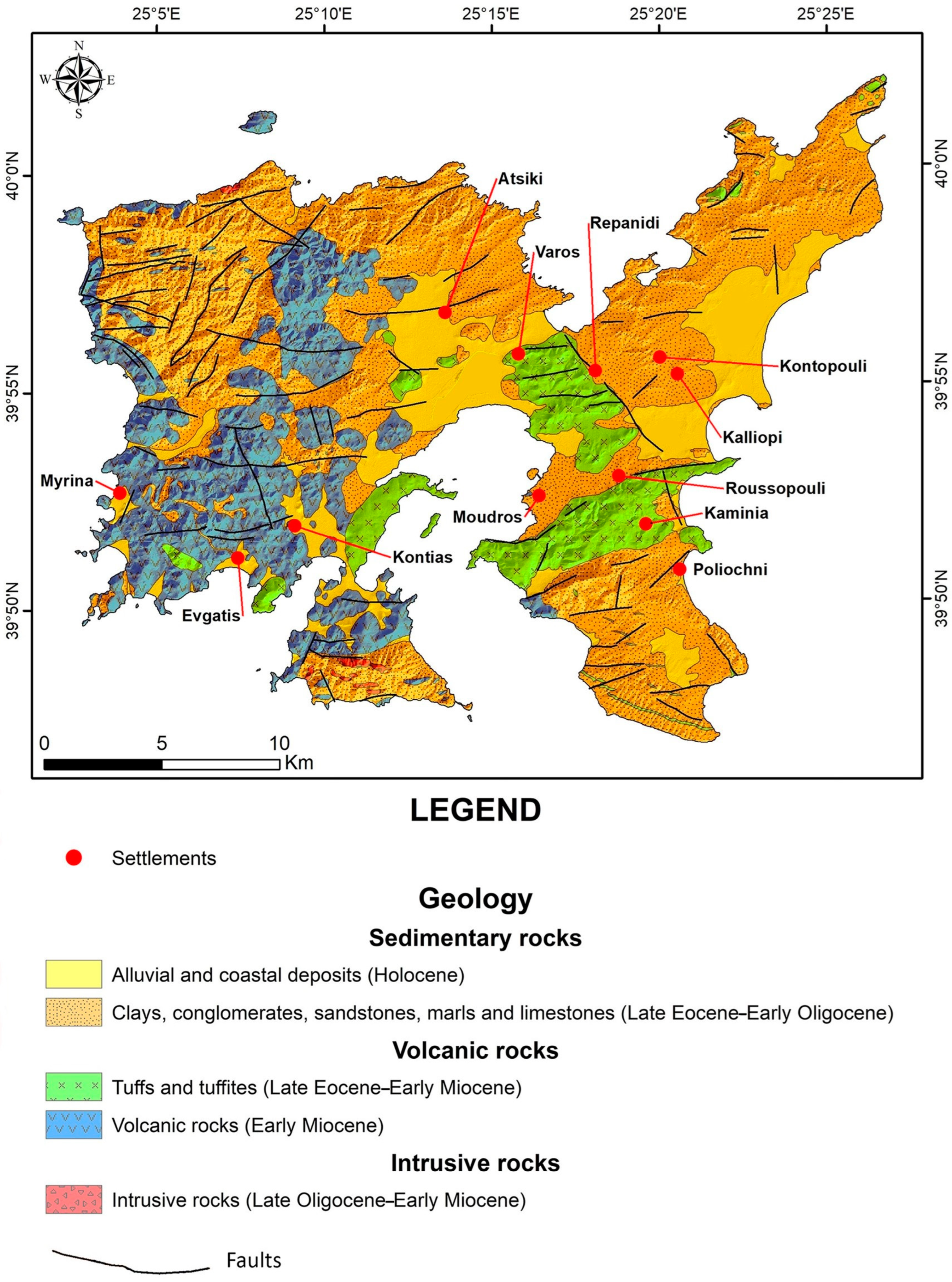
2.2. Geological Setting

The geology of the area (Figure 2) consists mainly of a clastic sedimentary sequence of the Oligocene and extensive volcanic rocks of the Early Miocene age [45,46]. The available geological maps [46,47] present a description of the dominant lithology. Previous stratigraphic and sedimentological studies (e.g., [48,49,50]) refer to a late Eocene–Oligocene stratigraphic range with a total thickness of less than 800 m. In particular, [46] have recognized three units within the sedimentary sequence: the Fissini-Sardes Unit that is the most extensive sequence and is characterized at its lower parts by sandstones, with greenish siltstones and shales, isolated flat blocks of cobblestone and gray nummulitic limestones and a layer of tuffs, while in its middle and upper part, thick layers of sandstone prevail over the silty clay; the Ifestia Unit consisting mainly of coarse-grained sandstones and conglomerates with its upper part mostly displaying silty clays, siltstones and marls, covered by an eroded surface associated with the volcanic activity; and the Therma Unit that consists of conglomerates restricted in the eastern and southeastern part of the island, presenting an abrupt change from the marine to continental environment, which corresponds to the beginning of the main volcanic cycle. [46] provided a rough age of middle Eocene to Early Miocene for the associated depositional intervals with the youngest age in accordance with [51] based on the plant fossils.
More recently, [52] have shown that the Lemnos volcano-sedimentary sequence exceeds 2200 m in thickness, extending from the late Eocene to the Oligocene/Miocene boundary, based on detailed calcareous nannofossil biostratigraphic analyses. The overall stratigraphic sequence of Lemnos, together with its equivalent sequence of Thrace, shows a deep marine environment of molassic type within a back-arc basin [53,54,55]. A blocky formation with olistolites of nummulitic neritic limestones is observed above the lowermost rhythmic alternations of turbiditic sandstones and pelites of the late Eocene, followed by several interlayering volcanic tuffs within a cyclical sedimentary sequence. Late Oligocene thick sandstones-conglomerates feature the middle part of the sequence, while impressive volcanic dikes and lava flows become frequent towards the upper horizons. The Early Miocene age has been documented at the sedimentary deposits of the northwestern part of the island [52]. The most extensive volcanic extrusions occur at the central–southern part of Lemnos and they are dated as Early Miocene (e.g., [56]). Plio-Pleistocene fluvial deposits are uncomfortably overlaying the pyroclastic succession, while aeolian sand deposits are recorded in the central–eastern part of the island [46]. Quaternary shallow marine limestones and calcarenites overlay the Eocene–Oligocene molasse-type sediments [47]. The Holocene coastal deposits at the archaeological settlement of Hephaistia and the Alyki Lagoon reveal a constant sea level rise during the last 7000 cal BP with fluctuations between temporary lagoon to shallow bay paleoenviroments; in particular, the determined shallow bay in the area of Hephaistia could have been used as a natural harbor before 4000 cal BP [57].
Innocenti et al. [46] recognized three units of volcanic rocks: the Romanou Unit pyroclastic sequence including a well-welded ignimbrite with gray and reddish pumice dated by radiometric K/Ar as 19.8 Ma [58] or 22.3 ± 0.7 Ma [59], and intercalations of continental sediments containing plant remains and silicified trunks; the Katalakkon Unit consisting mainly of lava domes that, according to the K/Ar radiometric dating by [58] and [45], formed after the pyroclastics of the Romano Unit (20–21 Ma); and the Myrina Unit, which represents the younger volcanics of the island aged between 19.3 and 18.2 Ma [45,58], mostly associated with lava domes.
Faulting is more intense in the SE of Moudros (Fanos-Agia Sofia fault) and in the NW part of the island with the Kondias/Kotsinas fault affecting the coastal zone close to the Hephaistia archeological site [60,61,62]. According to [63], all faults along the northern parts of the island are characterized by a dextral strike–slip component, while the faults on the southern parts of Lemnos, except for the Kaspakas and Moudros faults, are featured by an ENE–WSW strike. One of the most important faults on the island is that of Mourtzouflos, a strike-slip fault in the NE–SW direction defined as active by [64]. It belongs to an offshore fault zone and intersects with the mainland at Cape Mourtzouflos in the northwestern part of the island [63]. The Kaspakas fault is a normal NW–SE fault, which forms several fault scarps at the west side of the island, and the Kondias–Kotsinas fault zone represents a complex structure of multiple horizontal slip faults in a NE–SW direction, which crosses the island, affecting the coastline. Finally, the Moudros and Fanos-Agia Sofia faults are normal faults of the WSW–ENE direction that dip to the N–NW, located in the east and south of the island, respectively.

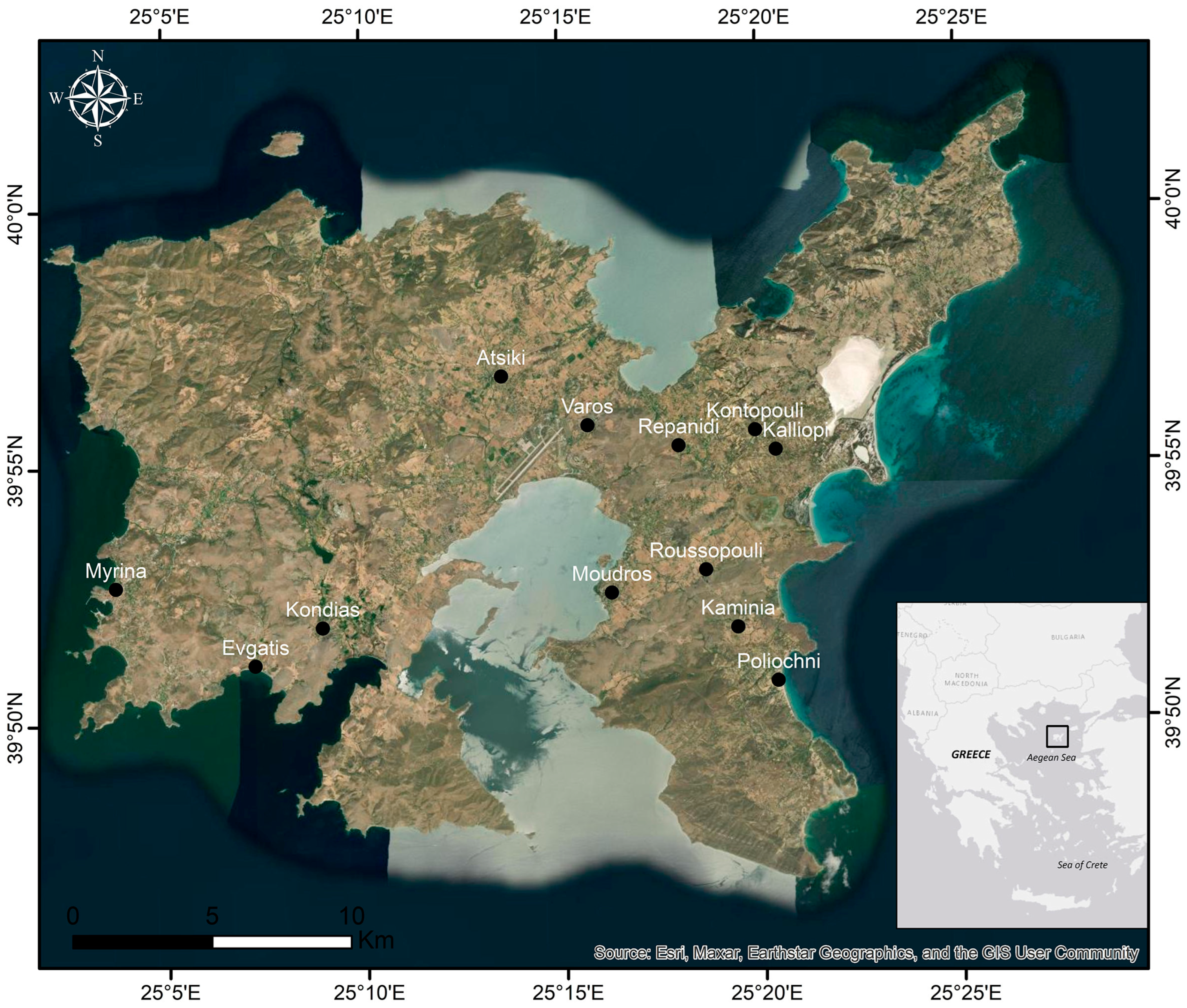
2.3. Socioeconomic Setting and Archaeological Values

Since 2011, the Municipality of Lemnos (capital city: Myrina) belongs to the regional unit of Lesbos, which in turn belongs to the region of the North Aegean. The Hellenic Statistical Authority keeps population data for the island of Lemnos beginning in 1920. The last census was made in 2011, while the next one was performed very recently (end of 2021). Despite the fact that the most recent census (Hellenic Statistical Authority, 2011) data available are relatively outdated, they are the only widely available and reliable population data so far.
The population evolution data (Table 1) show that there was a continual population increase until 1951, when the residents were about 24,000. Lemnos faced a significant population decline in the post-World War II period, when many residents migrated to the mainland Greece and abroad (Australia, Canada and USA). As a result, there was a gradual reduction until 2011, when the permanent residents of the island were about 17,000, while a decade later (2022), the current population has remained more or less stable (16,458). Lemnos is a relatively sparcely populated island with a population density of 35.7 residents per km2.
According to the 2011 census, the island of Lemnos has a total of 5915 employed citizens, out of whom 11.6% were employed in the primary sector (agriculture, forestry and fishery), 12.8% were occupied in the secondary sector, while a total of 4268 citizens (72.16%) were engaged in the tertiary sector (transport and storage, information and communication, public sector, administration and services, hotels and restaurants etc.). The sector with the highest employment is that of public administration and defense (24.6%). In accordance, wholesale and retail trade considerably contribute to the total employment (11.4%). Hotels and restaurants uptake a 7.4% of the total employment, implying that there is significant potential for the development of this sector. In 2019, more than 97% of the 34,914 tourists who visited Lemnos have stayed at a hotel, while this was reduced to 93% in 2020. In that year, the total number of visitors was restricted to 13,645, reflecting the COVID19 negative effect on the touristic activity of the island.
Overall, the socioeconomic features of the Lemnos local economy reveal a well-established development of both the primary and tertiary sector on the island (Table 1). Interestingly, the 19th century administrative division of the island resulted to a rather equal proportion of farmland and grassland for all villages, therefore offering sufficient space for agricultural production for all the communities of Lemnos, enhancing the activities of the primary sector [65].
The local economy is still based on the primary sector, although tourism is increasingly becoming an important activity. Lemnos hosts many local varieties of grapevines, among them are ancient ones such as “Lemnio” including the red variety of “kalambaki”, and imported ones such as “Muscat of Alexandria”, which adapted very well to the island’s microclimate [42], as they are rich in monoterpene content [66]. The roads of wine on Lemnos pass throughout the island from Myrina to Kaminia and Moudros, while in the area of Aghios Dimitrios Atsikis there exists over 45% of the Lemnos vineyards [67]. Cheese, meat and honey also compose the highlights of the Lemnos gastronomy. In particular, the famous “Katsikaki Limnou” (Lemnian goat) is delivered from local kids that graze mostly freely in the rich herbaceous vegetation of the island with its varieties of aromatic plants and scrub.
Lemnos exhibits a wealth of archaeological monuments. Among the most important ones, the Castle of Myrina dates back to the 4th millennium BC. Several sanctuaries distributed all over the island, such as that of Artemis in the area of Avlonas and the Sanctuary of Kaveirion dedicated to the Kaveirians, mystery male deities linked to Hephaestus, the ancient Greek god of fire, provide evidence of diachronous religiosity on the island. The Poliochni settlement is considered the oldest city in Europe that has existed since 5000 BC up to 1600 BC, when it was probably destroyed by an earthquake. The archaeological site of Hephaestia dates back to the Bronze era, while findings suggest that it was continuously inhabited until the Byzantine years. The exceptional findings coming from the excavations in Poliochni, Hephaestia and Kaveirion are exhibited in the Archaeological Museum of the island. Additionally, the Museum of Maritime Tradition and sponge-fishing and the Portianou Folklore Museum host pieces of evidence of the modern socioeconomic history of the island, such as traditional costumes and various objects from the daily life of the islanders.

3. Methodology

3.1. Evaluation Criteria of Geosites

A protocol to collect the most important information about the involved prominent geosites and archaeological sites was applied based on the calibration of a series of criteria for each location and the quantitative assessment of their scientific and touristic values. The criteria primarily covered the topics of geology in terms of its scientific and educational value, as well as ecology, culture and aesthetics; also, location, accessibility, services, territorial, morphological, socio-demographic characteristics and tourism infrastructure were considered. The outcome of the quantitative assessment was expected to enable decision making, thus providing a toolbox useful for sustainable Geo-Archaeo-tourism development at a local or regional level and form the basis for designing exciting “Geo-Archaeo-Routes”.
Despite the fact that there exists no single type of criteria for all geotopes [68], in the present study we adopted the evaluation method of [7,8], who proposed a series of 13 criteria (Table 2) covering 5 topics (geology, culture, aesthetics, tourism, ecology), incorporating the outcomes of [6,68,69,70,71,72]. Hence, the criteria used for the quantitative evaluation of Lemnos geosites in the topic of geology were defined as geological history, representativeness, geodiversity, rarity, (geo)conservation and education. In particular, the participation of the geosite in the geological history of the wider area, its representativeness, geodiversity, rarity and state of preservation were evaluated. Any educational value of the terrain belonged to the same category. By the term geodiversity we refer to the set of geological (rocks, minerals, fossils) and geomorphological (landscapes, natural processes) forms, while rarity quantifies the number of geosites on the island featured by analogous geological features.
The topic of culture included the sub-criteria of history–archaeology and religion. In this group, the human presence over the years was evaluated, particularly the association and connection of a geosite with regard to archaeological–historical findings, places of religious worship and other cultural monuments. The topic of aesthetics applied to the sub-criteria of visibility and relief differentiation, quantified as the number of locations on the island from which the geosite was visible; this is how the public recognizes a geosite according to its distinct visual characteristics. Finally, the topic of tourism was evaluated on the basis of the geosite accessibility and the tourist infrastructure of the wider area, whereas the topic of ecology was assessed by the sub-criterion of ecological value; namely, the contribution and integration of a geosite in the development of the surrounding ecosystems.
In order to use all criteria on a rational basis, a quantitative approach was required, therefore each sub-criterion was evaluated on a scale ranging 1 (low significance) to 5 (high significance).
The quantitative data produced when applying all the criteria set for the assessment of the geosites of Lemnos, led to an average value (Total Score = Sum of rating criteria/Number of used criteria), which determined their final classification as geosites at a global, national or regional/local level. More specifically, if Total Score > 3.5, the geosite was of global interest, Total Score values between 3.5 and 3.0 featured geosites at a national level, while values of Total Score < 3.0 marked geotopes of regional/local interest. A geodatabase was constructed in order to manage and analyze information with statistical and georeference tools.

3.2. Designing “Geo-Archaeo-Routes”

Specific geosites representative for the individual disciplines of geology (e.g., geomorphology, tectonics, stratigraphy, palaeontology, volcanology, etc.) blended with archaeological sites and other sites of cultural interest were selected for the creation of indicative “Geo-Archaeo-Routes”. The most important scientific information per site was compiled in the framework of each “Geo-Archaeo-Route” in a way such that anyone interested can follow them and enjoy natural beauty combined with cultural heritage. All data were imported in the G.I.S. ArcMap 10.4 software, and several maps were created, including the assessed geosites and the designed “Geo-Archaeo-Routes”. Additionally, satellite images from Google Earth Pro were auxiliary used for the determination of the “Geo-Archaeo-Routes”.

4. Results and Discussion

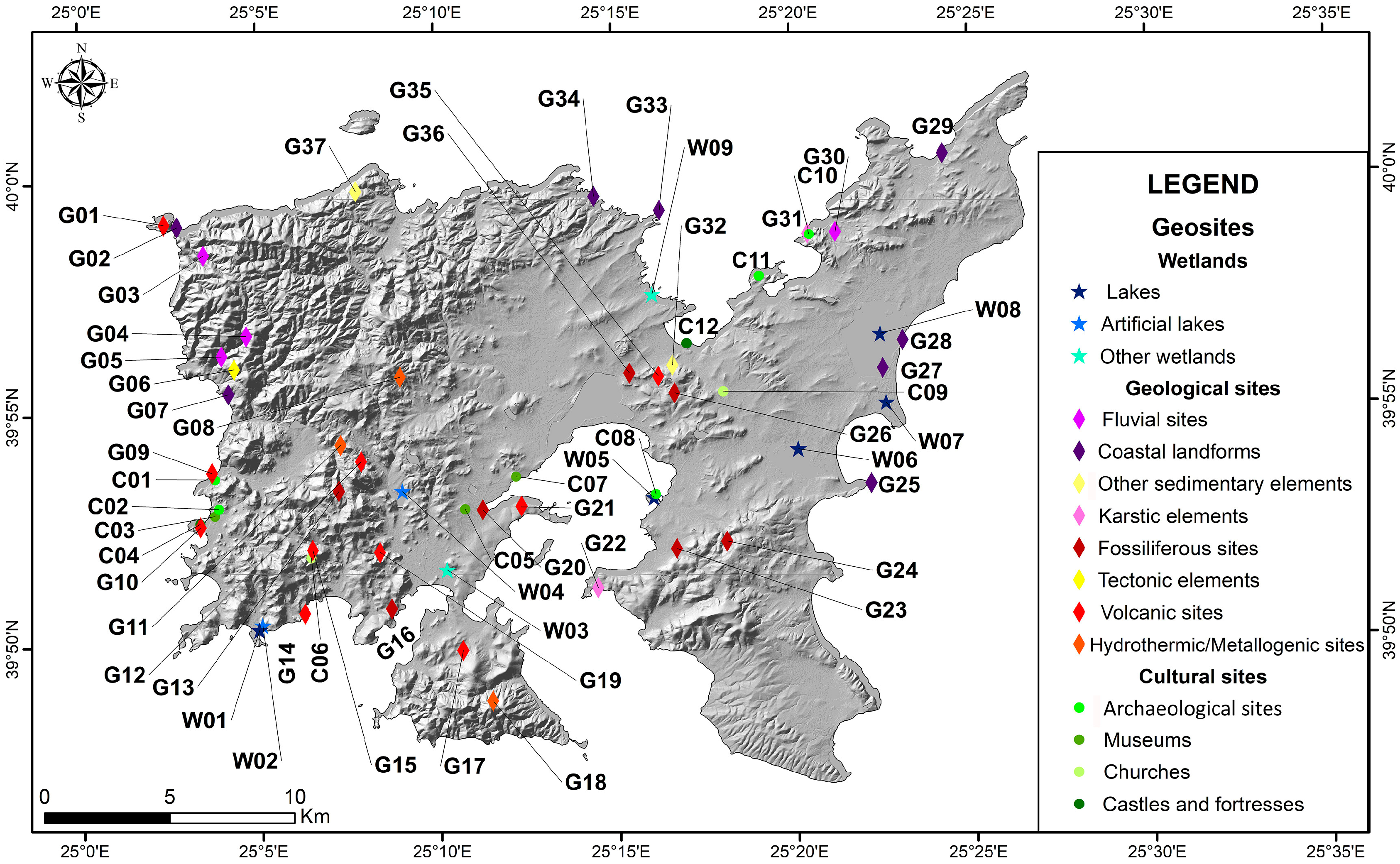
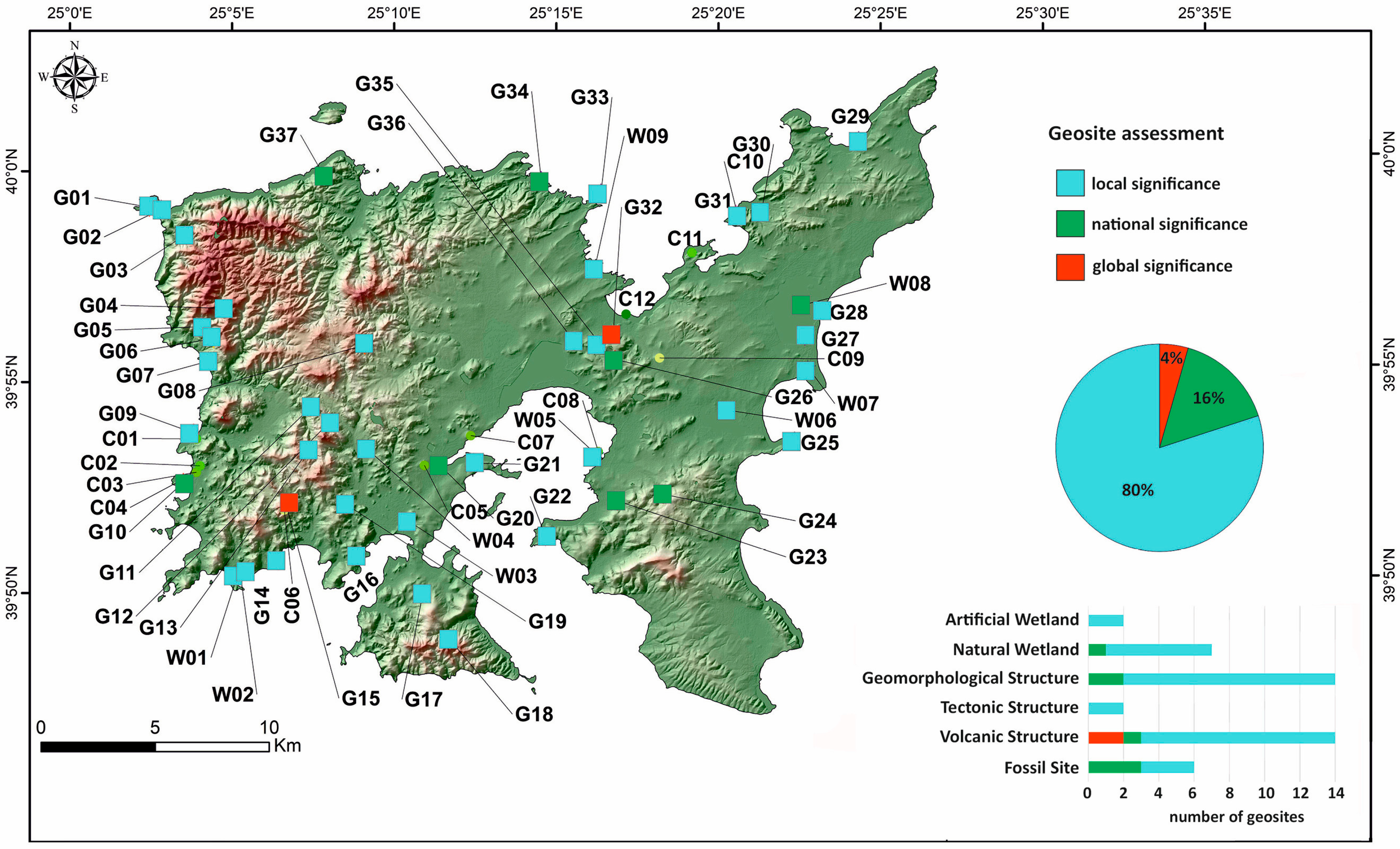
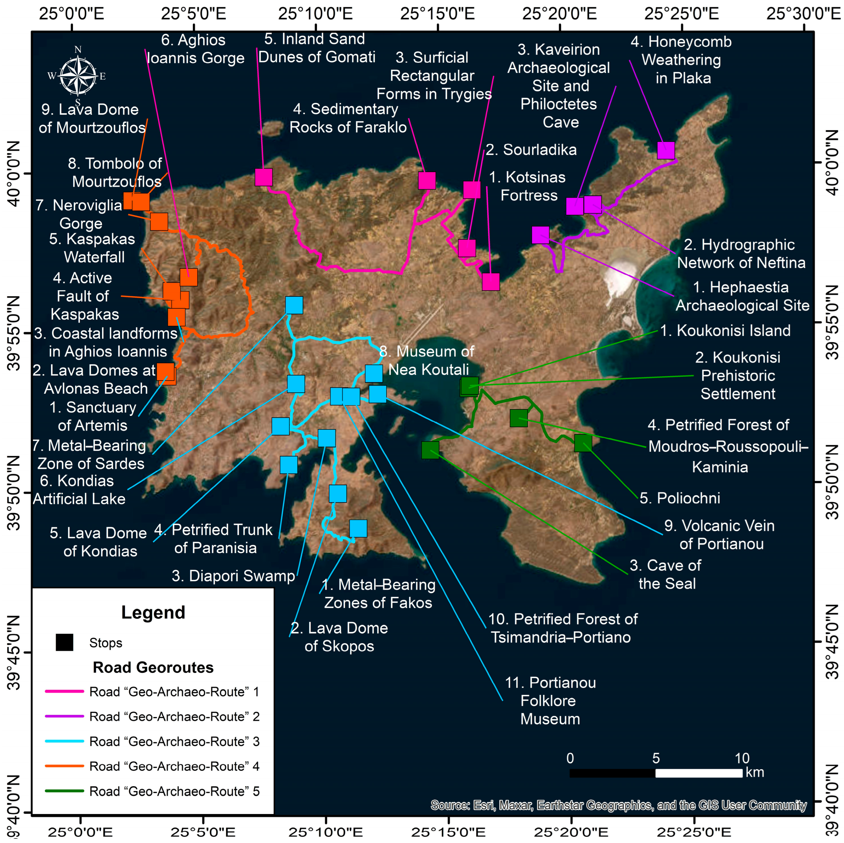
4.1. Distribution, Documentation and Assessment of the Geosites

Situated in an area of intense geological activity, the island of Lemnos hosts numerous geomorphosites (e.g., fluvial sites/rivers and waterfalls, gorges, small lakes, coastal plains and waterfalls, coastal landforms, karstic elements) and also volcanic and tectonic structures, fossiliferous sites and sites of mineral resources (e.g., [31]). In the present study, a total of 64 locations of high interest, including geosites (Table 3) and cultural sites (Table 3), were selected to construct specific “Geo-Archaeo-Routes” case studies. The involved geosites comprise volcanic, fossiliferous, fluvial, coastal karstic, hydrothermic and tectonic geological sites, as well as wetlands that were assessed based on the criteria proposed by [7] and, depending on the score they achieved, they were categorized into a local (54), national (6) and global (4) level of reference (Table 3, Figure 3).

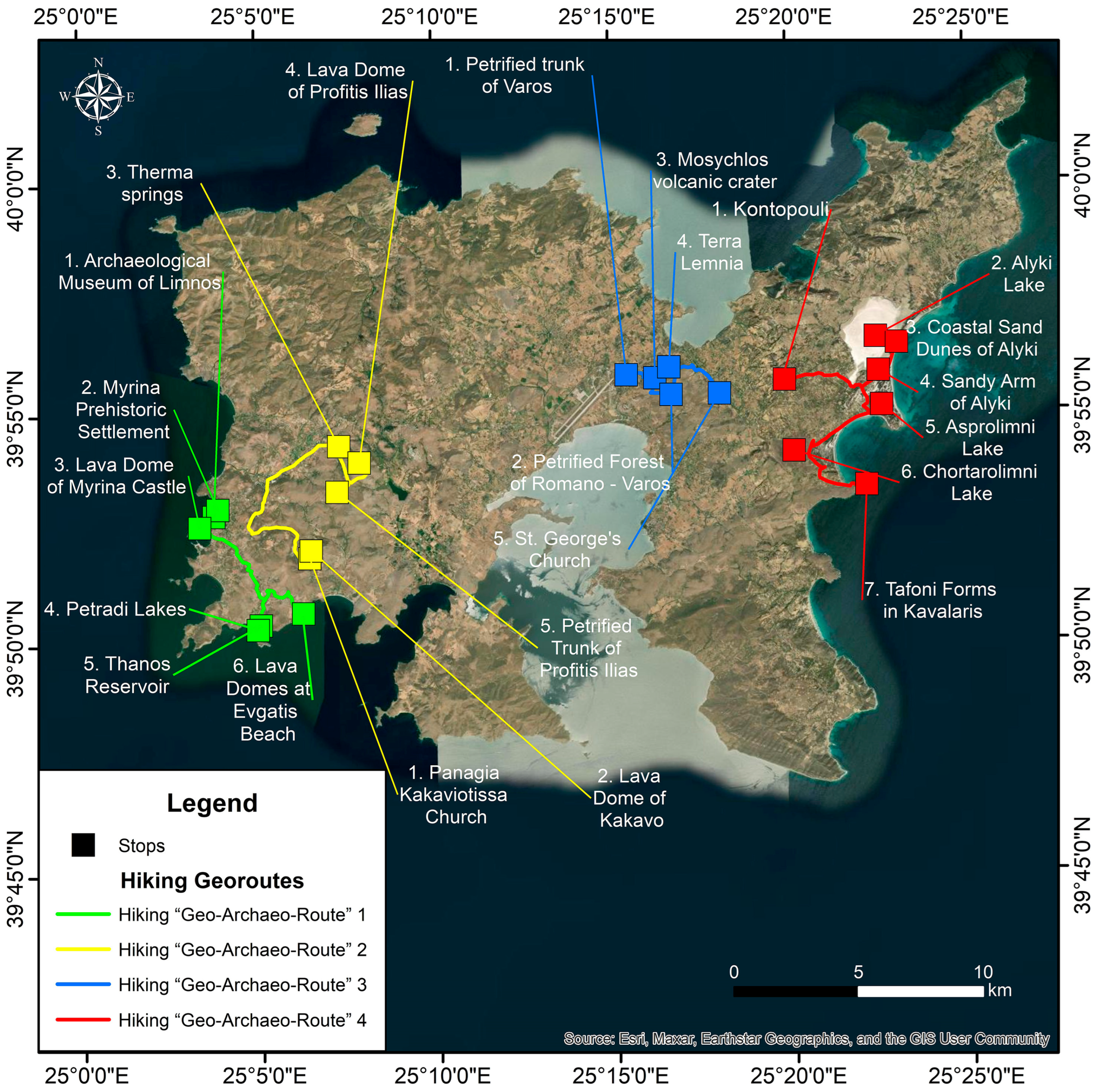
4.2. Selected “Geo-Archaeo-Routes” on Lemnos Island: A Spectacular “Nalture” Experience

The profound wealth of Lemnos is characterized by a variety of locations of geological, environmental and historical interest in its limited insular area (Figure 4), making it an ideal case study for developing and testing various types of “Geo-Archaeo-Routes” as a “nalture” experience in a geoethical perspective.
Through these “Geo-Archaeo-Routes”, visitors will be able to get to know the natural and cultural monuments of the area, the settlements, the traditional agricultural activities as well as the local products. The proposed routes are environmentally friendly, as either hiking trails or road trips using any means of transport (car, bike, local transport bus, etc.). A key element for the proper design of the route type is to serve the visitors in the best way covering a wide range of topics and to also be associated with good accessibility, safety and adequate available information. Thus, the hiking routes (Figure 5) were proposed to follow the already existing dirt roads network, the starting points being large villages and/or sites of ample interest. By establishing the Geo-Archaeo-touristic experience, we introduced a holistic geotouristic approach combining natural beauty, past civilizations and the history of the Earth in the unique geoenvironment of Lemnos Island.

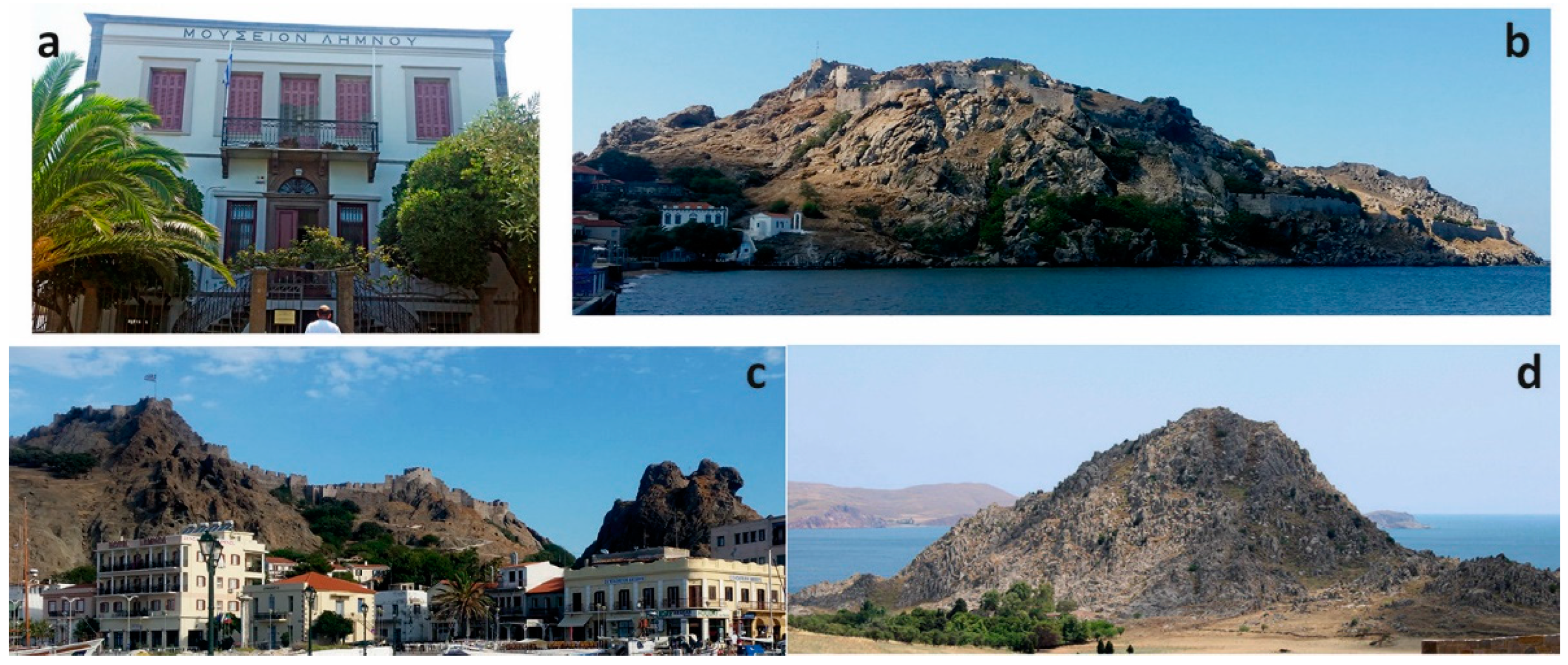
4.2.1. Hiking “Geo-Archaeo-Route” 1: Myrina–Thanos–Evgati Beach

This hiking route involves four cultural sites, one volcanic geological site and two geomorphosites (Figure 5). The starting point refers to the Archaeological Museum of Lemnos (C03; Table 4, Figure 3, Figure 4 and Figure 6a) in the center of Myrina, the capital of the island, where the visitors can admire stunning archaeological findings from all over the island as well as donations from private collections. The two-story neoclassical building that now houses the museum was built in the 19th century to accommodate the Turkish command post. In 1939, the building was sold by the community of Kastro to the Panlimniakos School Fund, on the condition that it would be donated to the public, in order to host the Archaeological Museum of Lemnos. During World War II, the archaeological treasures of Lemnos were transported to the Museum of Mytilene and to the National Archaeological Museum in Athens, and were returned back in 1961, after the restoration of the building. In the early 1990s a renovated exhibition was launched, mostly including findings from the excavations of the Italian Archaeological School and the Ephorate Prehistoric and Classical Antiquities in Hephaistia, Kaveirio, Poliochni and Myrina [73].
HikingGeo-Archaeo-Route1 continues with a visit to the Prehistoric Settlement of Myrina (C02; Table 4, Figure 3 and Figure 4), which is located only a few meters away from the Archaeological Museum and is considered an important residential center of the early Bronze Age. The Prehistoric Settlement of Myrina is located on the coastal site “Richa Nera”, on a volcanic geological basement (Figure 2). It was developed slightly earlier than the Poliochni settlement in the eastern part of the island, with its earliest phases being assigned to the first half of the 4th millennium BC [30]. Together with the rest of the prehistoric settlements on the island, the site reflects the importance of Lemnos during the Bronze Age associated with its strategic location in the vicinity of Dardanelles [74]. The residential remains and the fortifications mostly built by the volcanic rocks of the Myrina Unit [45] denote the dense and regular habitation of the settlement, with urban planning proved by the existence of roads between the houses, sometimes paved, and sewage systems with stone pipes, which occupied an area of 80,000 m2, and the area had a population of 3000–4000 inhabitants during its heyday [75]. Three building phases have been recorded with a total thickness of 5.10 m, reflecting a settlement with dynamic evolution in between the Late Neolithic and the Early Bronze age [76]. The Prehistoric Settlement of Myrina was destroyed many times potentially by fire or earthquakes, with the inhabitants rebuilding or repairing their houses according to their needs, as evidenced by the abandoned older buildings and the traces on the walls of all phases. The similarities in architecture and ceramic styles with the Poliochni settlement suggest the presence of a homogenous cultural group all over the island [76].
Afterwards, the route reaches the Lava Dome of Myrina Castle (G10) through the picturesque alleys of the city of Myrina. The impressive Myrina Castle, a geosite of national significance (Table 3, Figure 3, Figure 4 and Figure 6b,c), is located on the top of a lava dome of the volcanic Myrina Unit [45]. Lava domes are isolated hills of volcanic origin, formed mostly when the magma lost the dissolved gases while exiting the volcanic pore, resulting in an increase in its viscosity and thickness. Thus, the lava accumulated in the crater and cooled immediately, creating domes. The Myrina Unit consists of the youngest lava domes and occasional flows on Lemnos (21–18 Ma; [59]), suggesting a general evolution from shoshonitic to high-K calc-alkaline magmatism with time [45]. The Myrina Castle consists of both inner and outer surrounding walls, while it displays battlements, ramparts and 14 towers. The history of the castle dates back to the 13th century BC, when the Thessalians Minyans settled in Lemnos and fortified the hill with “Cyclopean” walls that are partially preserved outside the current fortress [77]. These were further enhanced by the Pelasgians, who conquered the island until the 6th century BC. The castle began to take the form in which it survives today during the 12th century AD, during the reign of the Byzantine emperor Andronikos I Komnenos. Over the years, the Byzantine castle experienced many conquerors, e.g., the great admiral of Romania, Philocalo Navigagioso, who built in 1207 a new castle on the middle plateau of the peninsula, and the Venetians who built the fortress to the north of the ancient castle and constructed the moat that surrounded the castle. In the 15th century the island was ceded by Ioannis VII Palaiologos to the Genoese Gateillusio family, who made repairs and some additions, giving the castle the form it has today. In 1479 and until 1912, the castle was under Ottoman occupation. Most of the buildings inside the castle date back to this period, which indicates the existence of a settlement [77]. Surprisingly, a restricted population of European fallow deer (Dama dama dama L.) lives in the fortress peninsula, as a result of a transferring of few individuals from the island of Rhodos in the early 1970s. The ground cover and forage availability is uneven throughout the peninsula, with the animals adapting their diet or searching for food outside the castle hill, therefore the principles of deer farming should be performed in order to maintain a healthy population [78].
The “Geo-Archaeo-route1 (Figure 5) then heads towards the village of Thanos, where the “twin” Petradi lakes are located. The water bodies on Lemnos include eighteen natural and three artificial wetlands [79], covering about 2.6% of the island’s area. Out of them, Petradi Lakes (W01; Table 3, Figure 3 and Figure 4), two neighboring seasonal wetland systems with rich succulent vegetation, are located south of the settlement of Thanos at Cape Asprokavos, being part of the protected insular small wetlands of Greece (Presidential Decree 2012, Government Gazette AAP 229/19.06.2012). Water is retained in them only during wet periods, while the natural continuation to the coastal zone is no longer existent [80]. Among the artificial water bodies, Thanos Reservoir (W02), 2.6 km from the homonymous settlement, was built in 1997 as an off-stream reservoir mostly fed by the Thanos torrent.
The route ends on the impressive Lava Domes at Evgatis Beach (G14; Table 3, Figure 3, Figure 4 and Figure 6d) that are composed by high-K rocks associated with the massive subduction of sedimentary material at the time of magmatic activity on Lemnos [81].

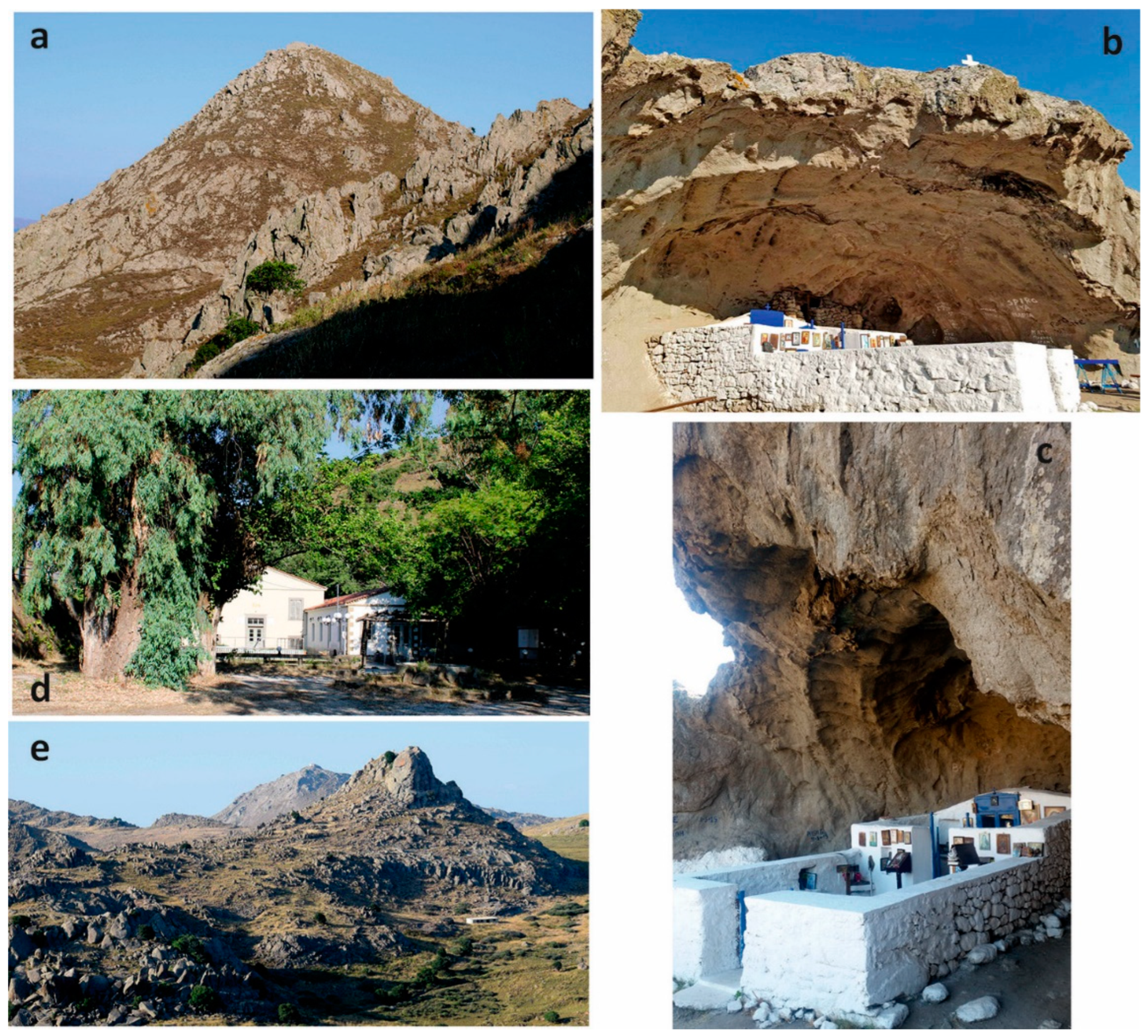
4.2.2. Hiking “Geo-Archaeo-Route” 2: Kakkavo–Therma–Profitis Ilias

Lava domes crop out in many areas on the island of Lemnos, as remnants of the intense volcanic activity that has shaped the island’s morphology. Most of them are located in the southwestern part of the island with the characteristic Lava Dome of Kakkavo (G15; Table 3, Figure 3, Figure 4 and Figure 7a), which consists of medium-K rocks [81]. This dome, a geosite of global significance (Figure 4), is selected as the starting point of “Geo-Archaeo-route2 (Figure 5). The site, beyond the impressive dome, hosts the Panagia Kakkaviotissa Church (C06; Table 4, Figure 3, Figure 4 and Figure 7b,c), a unique construction, having the roof of a cave as a natural cover. The Church of Panagia Kakkaviotissa is a chapel near the now-deserted village of Zematas, at the top of Kakkavo hill, from which it took its name. It became the property of the monastery of Megisti Lavra in 1305, when monks settled in the cave to protect themselves from the raids of the Ottomans, to practice asceticism and to praise the Virgin Mary. Nowadays, stairs have been built to make the access to the temple easier and the chapel is open to the public. Traditionally, the church hosts a celebration every year on the first Tuesday after the Greek Orthodox Easter [82]. The cave is not of karstic origin, as it was formed by the intense weathering caused by the wind and the rainwater that infiltrates the discontinuities of the volcanic rocks. It can also be described as a very large tafoni form.
Afterwards, the route leads to the Therma Springs (G11; Figure 3, Figure 4 and Figure 7d), which represent a geological hydrothermic–metallogenic site. They are thermal springs located on the western part of the island, near the village of Kondias. The water of Therma gushes from two springs, coming from a depth of about 1200 m. It has a temperature of 42.3 °C, it is odorless, transparent, palatable and slightly alkaline with a pH of 8.55. It has a high content of sodium (83.9 mg/L), chlorine (75.1 mg/L) and bicarbonate (84.6 mg/L) and is characterized as “meteoric, low in minerals, hypotonic and slightly radioactive thermal water” [83,84]. Thermal baths in the area of Therma have been functioning since 1548.
Finally, the hikingGeo-Archaeo-Route2 ends at the volcanic site of the Profitis Ilias Lava Dome (G12; Table 3, Figure 3, Figure 4 and Figure 7e) and the outlying area where the Petrified Truck of Profitis Ilias is located (G13). Velitzelos et al. (2019) stated that Lemnos Island was covered during Late Eocene–Early Miocene by extended forests of conifers, of arboreal dicotyledons as Laurales, Fabales and Myrtales, and monocotyledons, especially Arecales. Few fossil plant but numerous fossil wood remains have been identified in Lemnos, with only two conifers described, Glyptostrobus europaeus (Brongniart) Unger and Sequoia abietina (Brongniart) Erw. Knobloch [85].

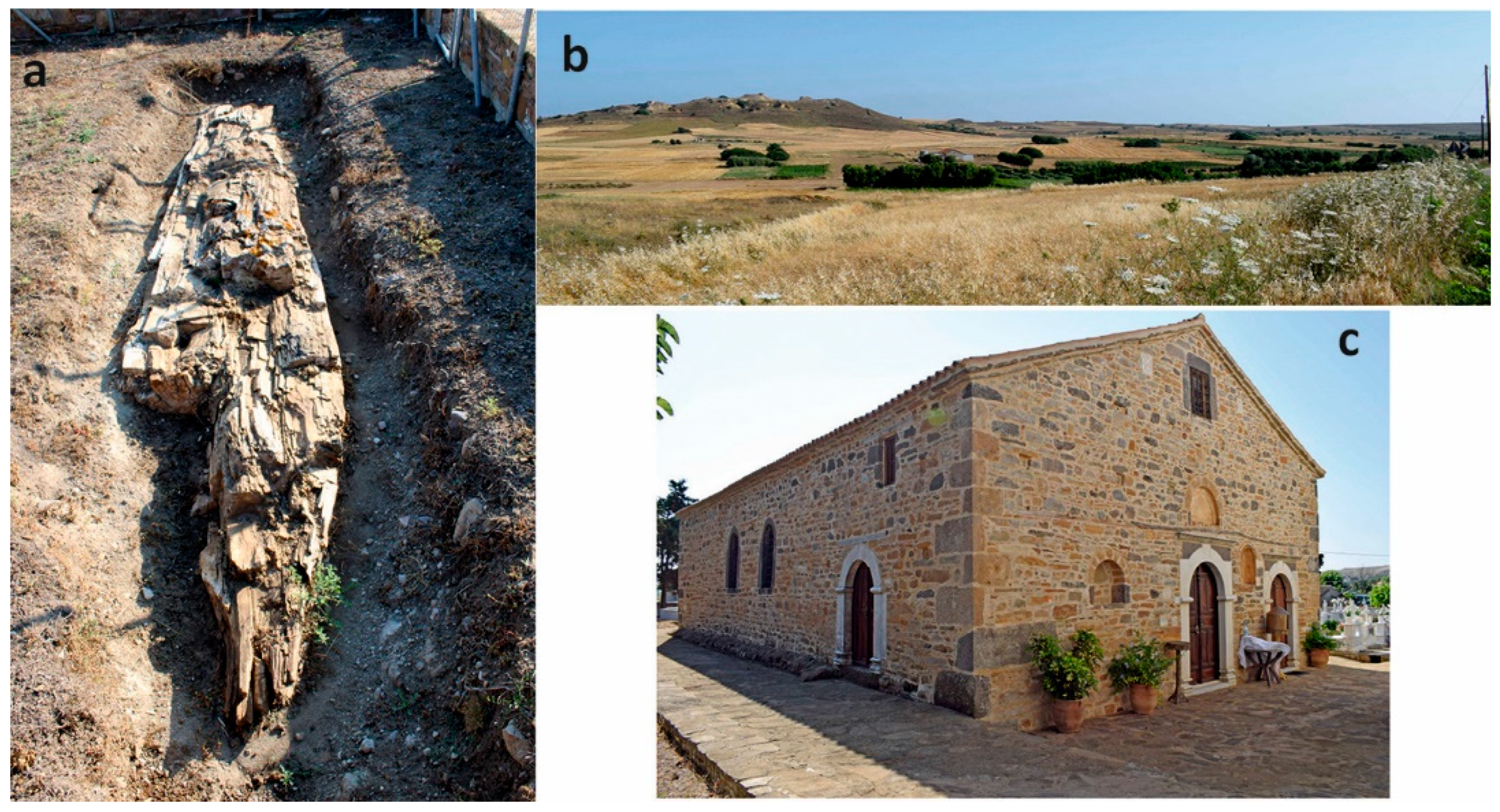
4.2.3. Hiking “Geo-Archaeo-Route” 3: Varos–Repanidi

The Petrified trunk of Varos (G36; Table 3, Figure 3, Figure 4 and Figure 8a) is the starting point of the hikingGeo-Archaeo-Route3 (Figure 5). In 2020, in the area of Varos, a huge, petrified tree trunk was discovered by members of the Natural History Museum of the Petrified Forest of Lesvos. It is a trunk of an angiosperm, probably a giant sequoia, more than eight meters high. As can be seen from the first phase of the excavations, the characteristics of the wood as well as the ends of its branches are preserved in excellent condition. Overall, the Petrified Forest of Lemnos, a geosite of national significance (Table 3, Figure 3 and Figure 4), consists of three areas of about 45,000 acres. The main area of 24,400 acres is located between Moudros, Roussopouli (G23) and Kaminia (G24), while the other two are located in Varos (G26), with an area of 14,350 acres and in Tsimandria–Portianou (G20), with an area of 7000 acres. Moreover, besides the Petrified trunk of Varos, there are also isolated occurrences of petrified trunks in Profitis Ilias (G13) and Paranisia (G16), while it is considered that there are hundreds of trunks on the island that have not yet been discovered. There are some lignotaxa previously described from the Petrified Forest of Lemnos, such as Laurinoxylon ehrendorferi, Cornoxylon pappi and a problematic conifer, initially described as Pinoxylon parenchymatosum, later revised as a species of Lesbosoxylon [86]. More recently, some palm fossil taxa were described [87] and a series taxa of fossilized wood have been further identified [88], such as Cupressinoxylon akdiki, Juniperoxylon acarcae, Tetraclinoxylon velitzelosii, Taxodioxylon gypsaceum, Taxodioxylon taxodii, Glyptostroboxylon rudolphii, Glyptostroboxylon tenerum, Pinuxylon pineoides and Pinuxylon halepensoides.
The next highlight of the route is the Volcanic Crater of Moschylos (G35; Figure 3, Figure 4 and Figure 8b). To the east of the village of Varos, the main morphological feature of the area is an inactive volcanic crater, where several hills surround a small plateau with fertile volcanic soils covered by crops. According to mythology, the Greek god of fire Hephaestus, a characteristic example of the personification of fires and volcanoes, established his workshop in this area [89].
Later on, the route passes from a global significance geosite (Table 3; Figure 3 and Figure 4), the hill where “Terra Lemnia” (G32) was mined. “Terra Lemnia” is a type of siliceous clayey mud derived from weathered volcanic tuffs [90] that outcrops only in Lemnos. From the Hellenistic Period until the beginning of the 20th century, “Terra Lemnia” was a widespread medicine throughout Europe, used as an "antidote" to poisons while also protecting against the plague. It was mined on Despotis hill between Repanidi, Kotsinas and Varos, which is located almost at the center of the island. Terra Lemnia” comes in three different shades, which differ depending on their mineralogical composition. The red “Terra Lemnia” has a high content of illite (41%) and kaolinite (37.6%), while it also contains quartz (17.7%) and hematite (3.8%). The yellow–gray “Terra Lemnia” consists mainly of montmorillonite (66%), while it also contains illite (18.1%), albite (9%) and quartz (6.9%). Finally, the white “Terra Lemnia” consists mainly of dolomite (65.2%), while it also contains kaolinite (17.3%), illite (9.9%) and quartz (7.6%) [91].
The route ends at the village of Repanidi where the historical old Church of Aghios Georgios (C09; Table 4, Figure 8c) is located. This is a cemetery church declared as a historical monument, most probably founded in 1860. It is a typical example of the ecclesiastical architecture in Lemnos, a three-aisled basilica with neoclassical influences. The highly aesthetic wood-carved altarpiece of the church and the bright colors of the portable icons represent a unique art developed during the post-Byzantine era [92].

4.2.4. Hiking “Geo-Archaeo-Route” 4: Kontopouli–Kavalaris

This hiking route (Figure 5), starting from the picturesque village of Kontopouli with the traditional stone houses and churches, reaches the southern edge of the national significance geosite Alyki Lake (W08; Table 3, Figure 3, Figure 4 and Figure 9a,b), a natural salt pan, which is the largest seasonal water surface on an Aegean island, with annual salinity ranging between 3.5 and 25‰ and indigenous flora comprising of Arthrocnemum glaucum, A. fruticosum, Chenopodium sp., Cynodon dactylon, Phragmites australis, Plantago sp., Salsola kali, Scirpus holoschoenus, Suaeda maritima, Trachomitum venetum, Allium bourgeaui and Phyla nodiflora [79], and important avifauna, e.g., Tadorna ferruginea and Burhinus oedicnemus [93]. At its southeastern edge, a sand spit can be seen, inhabited by rich avifauna. The neighboring Asprolimni Lake (W07; Table 3, Figure 3 and Figure 4) is a similar lake to Alyki but is much smaller in size and between them the area is covered by sand dunes. Then, the route follows the coastal road of the impressive beach of Keros, reaching the lake of Chortarolimni (W06; Table 3, Figure 9c), the largest seasonal swamp in the Aegean, with slightly brackish waters (annual salinity of around 0.5‰), surrounded by halophytic vegetation consisting of Arthrocnemum glaucum, Salsola soda and Scirpus lacustris, and extended sand dunes that protect the lake from the waves and the inflow of sea water [79].
Alyki (W08), Asprolimni (W07), the smallest out of the three lakes, and Chortarolimni (W06) represent a complex dynamic hydrogeological system of three lakes, developed on the eastern coast of the island. Due to the rare species it hosts (e.g., porpoise, bottlenose dolphin), as well as the habitats (Mediterranean grasslands with Juncus, saline steppes with shifting coastal dunes), the area is under the protection of the Natura 2000 network [94]. The wetland is featured by the development of sand dunes along the coast and the impressive presence of thousands of flamingos during the winter [79]. The paleoenvironmental evolution of the coastal plain has been studied by [57,95], who proved that a shallow marine environment with significant freshwater input was prevailing in between 5100 and 1040 BC, the paleo-shoreline being located 500 m in front of the present day shoreline. Later on, a mesohaline lagoon to shallow bay developed in the period between 1040 BC and 760 AD [95]. Overall, the paleoenvironmental evolution in this area has also been affected by the Black Sea outflow, starting at approx. 7500 cal. BP [96].
A special morphological feature of the area is the development of the Coastal sand dunes of Alyki (G28) along the Alyki coast. Their formation requires a large supply of sand and strong winds that blow for a long time, as well as the appropriate orientation of the coast in relation to the wind conditions [97]. Coastal sand dunes are the dominant landform on the eastern coasts, creating the barrier between the sea and Alyki lagoon [95]. The Sandy Arm of Alyki (G29; Table 3, Figure 3 and Figure 4) represents a sand barrier that has been gradually created probably later than 820 AD [95].
Towards the southern tip of the gulf of Keros, the route ends at the spectacular Tafoni forms in Kavalaris (G25; Table 3, Figure 3 and Figure 4), found in the volcanic rocks on the east of the island at cape Kavalaris. These weathering formations resembling small caves are often characterized as “aeolian erosion formations”, however, their development is partly due to wind action, but is mainly due to chemical weathering by the salt contained in the sea water, which is transported by the wind [98,99]. They are developed especially in medium to coarse-grained silicate rocks with granular fabric, such as granites and granodiorites or even sandstones [99].

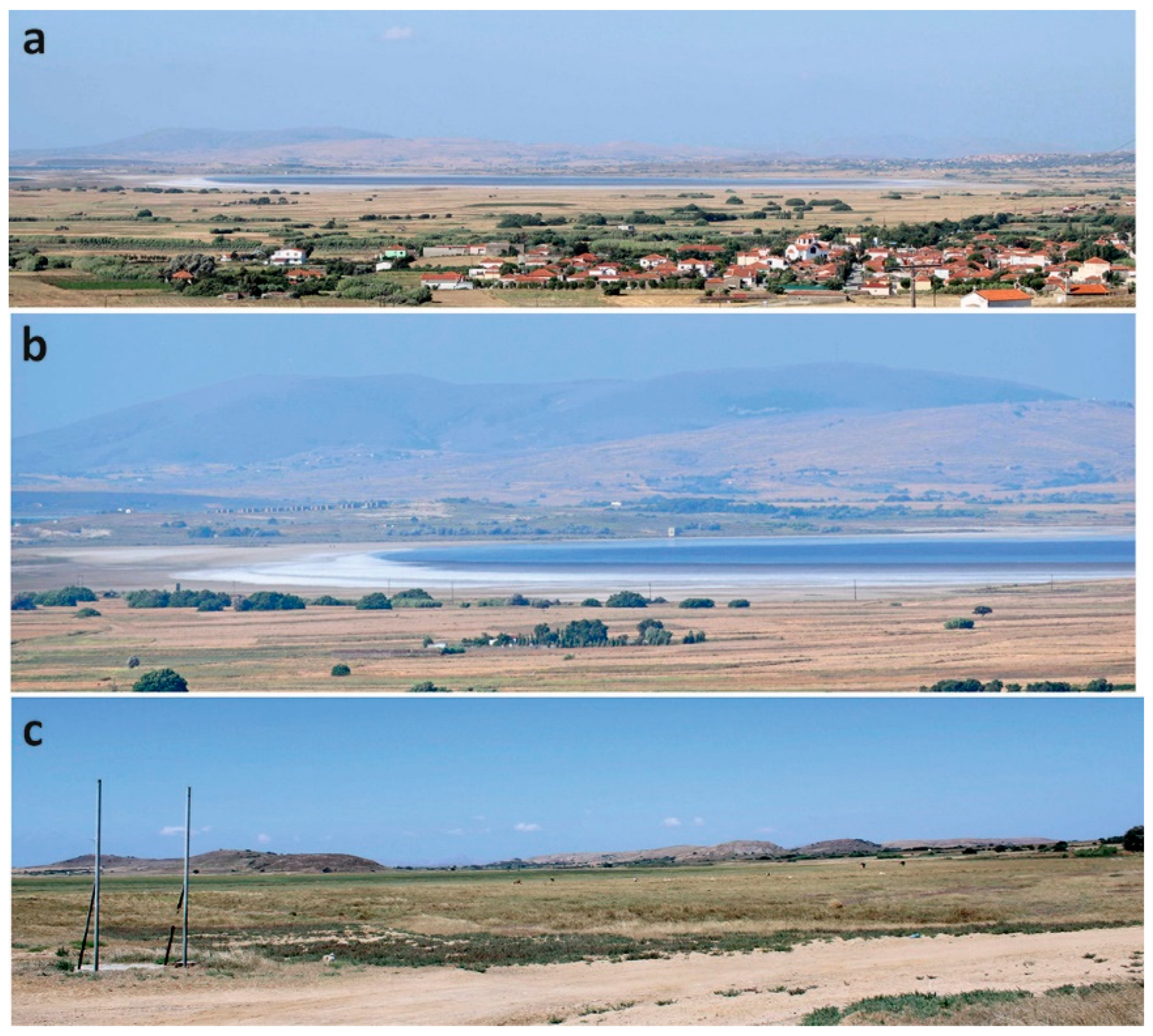
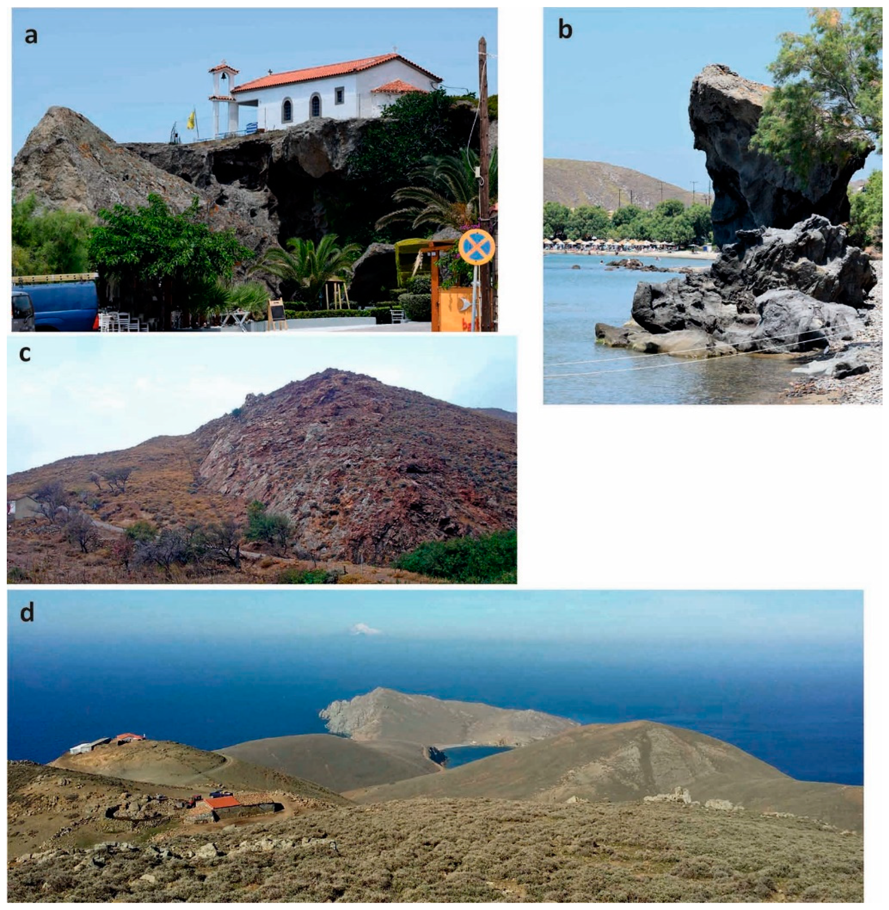
4.2.5. Road “Geo-Archaeo-Route” 1: Kotsinas–Faraklo–Gomati

The starting point of the road “Geo-Archaeo-Route1 (Figure 10) is the Kotsinas Fortress (C12; Table 4, Figure 3, Figure 4 and Figure 11a,b), located in the village of Kotsinas, in the bay of Bournias. It was built in the 13th century probably by the Venetian Navigaiosi family who ruled the island. The fortress was built on an artificial hill and had a rectangular shape. Its three sides were surrounded by a fortification moat, while towards the sea there were four-sided defensive towers. Inside there was a chapel built in 1415 and dedicated to Virgin Mary [100]. Nowadays, only a few relics of the fortress remain, as the Venetians themselves destroyed it when they left Lemnos in 1657. The chapel has been replaced by the church of Zoodochos Pigi. Τhe statue of Maroula of Lemnos in the church yard was made in honor of the heroine Maroula, who fought bravely in 1478 during the siege of the Kotsinas fortress by the Ottomans.
Northwest of the Kotsinas settlement, the route leads to Sourladika (W09; Table 3, Figure 3 and Figure 4), which denotes a rare wetland system, consisting of several seasonal small brackish to fresh water lakes formed in cavities between the coastal sand dunes [93,101]. The area hosts rich vegetation, and among other faunal elements, a large number of wild rabbits.
Towards northeast the route reveals the Surficial Rectangular Forms in Trygies (G33), impressive erosional forms [102] similar to the Sedimentary Rocks of Faraklo (G34) that are unique outcrops with yellow spherical landforms (Figure 11c–e), a geosite assessed to be of national significance (Table 3; Figure 3 and Figure 4). It has been erroneously believed that these landforms formed when volcanic lava came in contact with the sea water, but they most likely are the product of coastal erosion. In the area of Trygies and Faraklo, the geological background consists of clay–sandstone alternations, which constitute the majority of the outcropping sedimentary turbiditic rocks. Particularly in the area of Faraklo there is an increase in the thickness and frequency of sandstone benches, which indicates deposition in submarine fans. The sandstones are fine-grained to medium-grained, containing quartz, feldspars, lithic fragments of various rocks (schists, volcanics, limestones, etc.), titanite, chlorite, chromite grains and iron oxides–hydroxides [47,103]. In Cape Trygies, thick-stratified sandstones and cobbles are observed with flow structures and evidence of submarine sliding [47]. On the upper surface of the sandstone beds, spectacular forms are observed, such as sandstone spheres and surficial rectangular and honeycomb cavity features as the result of coastal erosion.
Finally, the route ends at the Inland Sand Dunes of Gomati (G37) or “Pachies Ammoudies”, which are located at the northern part of the island [104]. With an area of about 70 acres, this ecosystem is characterized as a unique desert environment in the whole of Europe (Figure 11f–h) and a geosite of national significance (Table 3; Figure 3 and Figure 4). These inland sand dunes, being important but also sensitive habitats, certainly comprise a phenomenon rare for an insular area, thus they are habitats protected by the Directive 92/43/EEC. They have been created by the strong NE winds that transport the sand from the nearby beaches as evidenced by the scarce presence of shallow marine environment benthic foraminifera (e.g., Elphidium crispum and fragments of echinoid spicules; Figure 11i), as well as by the aeolian erosion of the outcropping Oligocene sandstones. The local vegetation consists mostly of Pancratium maritimum (white lillies), Ammophilala arenusus agnaria, Sarcopoterium spinosum, Thymus vulgaris, Nerium oleander and Olea europea var. oleaster, etc.

4.2.6. Road “Geo-Archaeo-Route” 2: Hephaistia–Kaveirion–Plaka

This route (Figure 10) begins at the Archaeological Site of Hephaistia (C11; Table 4, Figure 3 and Figure 4), built north of the Pournias gulf, which was in historical times the second most important city of Lemnos after Myrina. Excavations carried out by the Italian School of Archeology and the Ephorate of Prehistoric and Classical Antiquities revealed antiquities that prove the habitation of the area from the Late Bronze Age to the Byzantine times. There are ancient ruins in almost 10 layers of a complex city displaying buildings, palaces, baths, Christian churches, a Hellenistic Roman theatre and an 8th to 6th century BC sanctuary, dedicated to the Great Goddess Lemnos, who corresponds to Goddess Artemis. The Late Bronze Age settlement is marked by Mycenean pottery and includes the so-called “walls of the isthmus” between the gulf of Pournias and the lagoon to the east, as also a small paved road running in a north–south direction [105]. The Mycenean village was abandoned abruptly, reflecting a time of new populations arriving in the area. The next chapter in the history of the settlement from the second half of the eighth to seventh century BC was featured by the Archaic Lemnian society with strong social stratification, the presence of an acropolis, a sanctuary and the imprint of the Mediterranean economy based on grain, wine and metal [105]. The sanctuary remains are preserved at two levels, while the central space had desks on both sides, on which votive offerings and parts of a cult statue of an ancient deity, the Great Goddess Lemnos, were found [106]. The ancient theater is the most important monument of the Archaeological Site of Hephaistia (C11; Figure 12a) and is associated with an Athenian settlement on the island. Its caveat was built on the semi-rocky slope of a hill, and on earlier sanctuaries of the 7th–6th century BC [107] stated that it is the most ancient Greek theatre, although [105] questions this. Other important findings within the archeological site are a cemetery dating from the mid-8th to the 5th century BC, two ceramic laboratory incinerators of the Hellenistic period (2nd–1st century BC) discovered near the sanctuary, while southeast of the city near the sea, bath facilities and remains of houses of the Hellenistic and Byzantine times have been discovered. Hephaistia was set on fire by the Persians in 511 BC but it was built again by the Athenians, being capital or co-capital of the island and the economic center until the Middle Ages, when its harbor was gradually embanked [108]. In the same location, the outdoor Ancient Quarry of Hephaistia (Figure 12b) at the northeastern part of the Paleopolis peninsula represents a site where porous limestone was mined during Classical to Hellenistic times and was widely used in the ancient city of Hephaistia [109]. Nowadays, a large part of the quarry is covered by the sea.
The road Geo-Archaeo-Route 2 is continuous with the Rejuvenated Drainage of Neftina (G30) that represents the spectacular case of the final stage of the erosion cycle of a fully evolved hydrographic network (Figure 12c,d), indicating a local neotectonic uplift of a fault-bounded block in the area affected by the Kondias–Kotsinas fault zone [63]. Shallow riverbeds are furrowing the smooth morphological relief during the current stage of geomorphological relief rejuvenation.
Nearby at Cape Chloe, the Sanctuary of Kaveirion (C10; Figure 3, Figure 4 and Figure 12e) represents one of the oldest sanctuaries in the Aegean from the second half of the 7th century BC [110]; three telesteria have been discovered during the archeological excavations of the Italian Archaeological School, dating back to Archaic, Hellenistic and late-Roman times [111]. The religious ceremonies performed to honor the Kaveirians, mystery male deities sometimes called Hephaistoi, indicating their association with Hephaestus, the god of fire and blacksmiths and a secret cult, the so called Kaveirian Mysteries [112]. The oldest Archaic building consists of an irregular rectangular monument similar to the Acropolis of Hephaistia that was also abruptly abandoned at the end of the 6th century BC [105], featured by a circular protrusion used as an altar or a podium. The Hellenistic telesterion (200 BC) is a prostyle building with twelve Doric columns. It consists of a large central space, divided vertically into three parts by two rows of Ionic columns, with an opening to the north. Several items of the Classical and Hellenistic phase have been found in the buildings, including many offerings, small lamps, compasses, ceramics and pieces of sculptures, clay and copper statues, inscriptions, etc. During the years of the Roman Empire, between the 2nd and 3rd century AD, the telesterion was looted and burned and when the area was abandoned the site was used as a “quarry” for the construction of younger buildings. The late-Roman telesterion is built over the Archaic one clearly reminiscent of the destroyed Hellenistic temple, being a 17-m-long room, divided into three parts by two rows of five columns and a main hall separated from the sanctuaries by a corridor [111].
In the same area, the Cave of Philoctetes (G31; Table 3, Figure 3, Figure 4 and Figure 12f), a coastal cave located below the Kaveirion Archaeological Site, has been created by the effect of sea waves on the rocky coastal cliff consisting of sedimentary rocks, mostly sandstones, and has two entrances, the main one by the sea and a small one on the land side [95]. It took its name from the king of Thessaly Philoctetes, who according to mythology, resorted to it, when on the way to the Trojan War he was left on the island by the Achaeans because he had been attacked on the leg by a poisonous snake. He remained in the cave for about ten years and was healed with the help of “Terra Lemnia” [107].
The route ends towards the northwest coast with the Honeycomb Weathering formations in Plaka (G29; Table 3, Figure 3, Figure 4 and Figure 12g) that are developed on the exposed sandstones and tuffs. The phenomenon is intense, due to the wind action and the chemical weathering caused by the salty sea water that enters the rocks through the discontinuities.

4.2.7. Road “Geo-Archaeo-Route” 3: Diapori–Portianou–Sardes

The starting point at the metal-bearing Zone of Fakos (G18; Table 3, Figure 3 and Figure 4) is a highlight of Road Geo-Archaeo-Route 3 (Figure 10), developed in the periphery of a subvolcanic body of quartz monzonitic composition that intrudes the shoshonitic andesites, trachyandesites and trachytes volcanic rocks and the quartz-rich medium-grained sandstone sediments in the southern part of the Fakos peninsula, featured by intense hydrothermal alteration and quartz veining [113,114]. The area stands out due to the volcanic penetrations within the sedimentary rocks and the gold ores; i.e., the Fakos Cu–Mo–Au prospect, comprises the first occurrence of porphyry-related tourmaline in Greece [115]. The faults in the Fakos peninsula follow the general NE–SW and ENE–WSW directions featuring the whole Lemnos island, significantly contributing to the deposition of subvolcanic bodies and facilitating the flow of the hydrothermal magmatic liquids responsible for metallic mineralization [116]. Three metal-bearing zones are exposed on the peninsula. The first is located in the southern part, in the quartz veins within the sandstones and quartz monzonite. The second zone is located in the western part, while the third and largest is located in the eastern part, displaying a length of 1 km and a thickness of 10 m and is characterized by a high concentration of gold as an indication of a magmatic-hydrothermal contribution to the vein system [117].
To the north, the impressive Lava Domes of Skopos (G19; Table 3, Figure 3 and Figure 4) and Kondias (G17; Table 3, Figure 3, Figure 4 and Figure 13a) are associated with the depression caused by the Kornos–Kondias fault that hosts the intensive magmatic activity of the Katalakkon and Myrina volcanic units, involving balloon-shaped domes of calc-alkaline shoshonitic affinity, emplaced between 22 and 18 Ma in the Early Miocene [45,81].
In between the Lava Domes, the route meets the Diapori Swamp (W03) and the Petrified Trunk of Paranisia (G16). The Diapori Swamp (Table 3, Figure 3 and Figure 4) is a Natura 2000 Network protected wetland system consisting of shallow freshwater swamps, scattered small seasonal lakes, salt marshes and extended sand dunes located in the area of Kondias bay [80]. The area hosts numerous amphibians and reptiles [44] and supports considerable amounts of threatened avifauna species (e.g., Tadorna ferruginea, Burhinus oedicnemus) on an annual basis [29]. The nearby Kondias Artificial Lake (W04; Figure 3 and Figure 4) covering an area of 1,100,000 m2 in the southeastern part of the island represents together with the Thanos reservoir the largest artificial water bodies on Lemnos [29], formed after the building of a soil dam in 1976.
Moving northwards, Road Geo-Archaeo-Route 3 reaches the village of Sardes, where the Metal-Bearing Zone of Sardes (G08; Table 3, Figure 3 and Figure 4), a system of quartz, has been developed in zones within the volcanic rocks and sandstones, in the same direction as that of the Fakos zones [118]. This interesting metal-bearing zone includes pyrite, marcasite and veinlets of silica [114].
The route continues to the southeast with a stop at the Museum of Maritime Tradition and Sponge-Fishing of Nea Koutali (C07; Table 4, Figure 3). This cultural site is blending nicely within Road Geo-Archaeo-Route 3, highlighting the history of the people of Koutali, by presenting the craft of sponge-fishing and also archeological findings brought up by the Koutalians during the sponge dives [119].
In the area of Portianou, the Road Geo-Archaeo-Route 3 encounters several fossiliferous localities of in situ silicified wood hosted within pyroclastic rocks of the Romanou volcanic Unit [45], with the most important ones being the Petrified Forest of Tsimandria–Portianou (G20; Table 3, Figure 3 and Figure 4). The Romanou Unit that outcrops in the area is the main host of the petrified woods on Lemnos island, consisting of up to 160 m thick pyroclastic flow deposits, classified as K-rich dacites to latites and are radiometrically dated as 19.8 Ma old [45]. The petrified trunks found could have been formed partly by devitrification processes by near neutral-pH fluids in swamp depressions, which were flooded by the upwelling hydrothermal fluids in the periphery of the magmatic-hydrothermal center of the Fakos peninsula [120].
After passing through the Petrified Forest of Tsimandria–Portianou (G20), the route heads towards the Volcanic Vein of Portianou (G21; Table 3, Figure 3 and Figure 4), located at the cape of Punta. At the edge of the cape, the mysterious Pyramid of Lemnos (G21) represents according to a non-proven point of view, a 1920’s Cossacks cenotaph, in honor of those who lost their lives in exile on the island during the Russian Civil War [121]. Another interpretation links this building with military constructions, potentially made by Australian mechanics during March of 1915 in the first world war [122].
Finally, a visit to the Portianou Folklore Museum (C05; Table 4, Figure 3) is a cultural must of Road Geo-Archaeo-Route 3. The Folklore Museum located in the Portianou village was founded in 1995 and is housed in a two-story traditional building, exhibiting the life-mode of the Lemnos inhabitants of the previous centuries, e.g., traditional costumes, various knitting tools, fireplace and cooking utensils, handmade wedding dresses and laces, agricultural tools, etc.

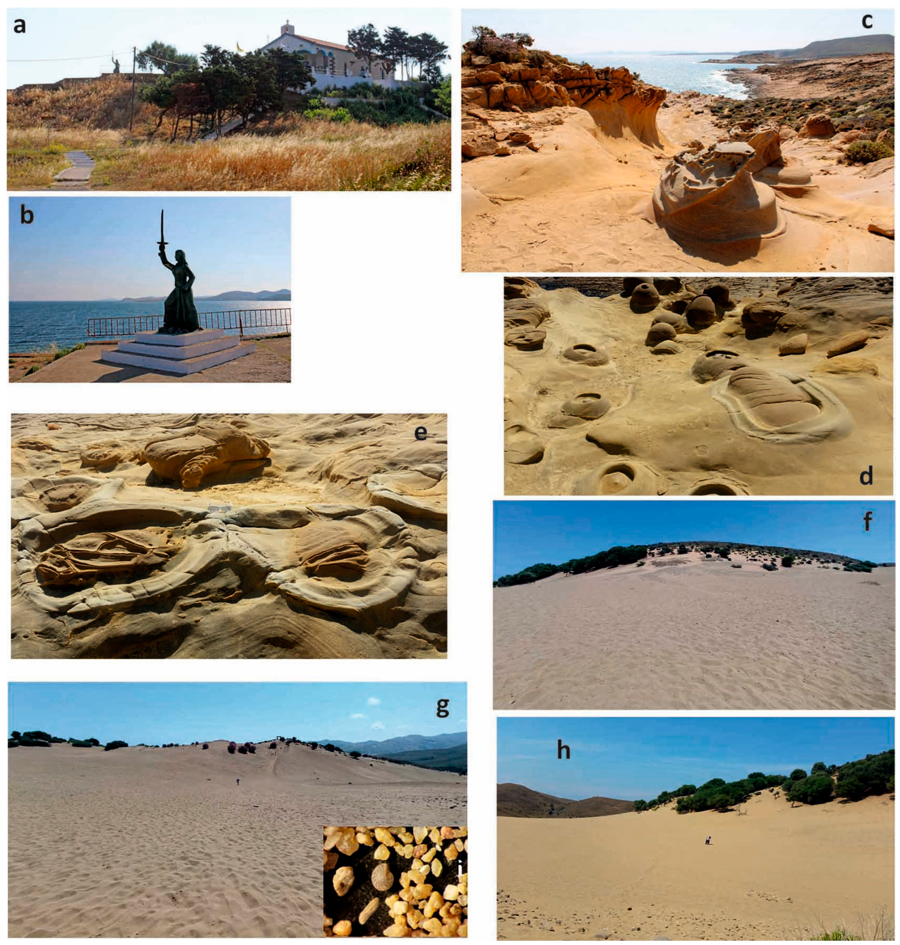
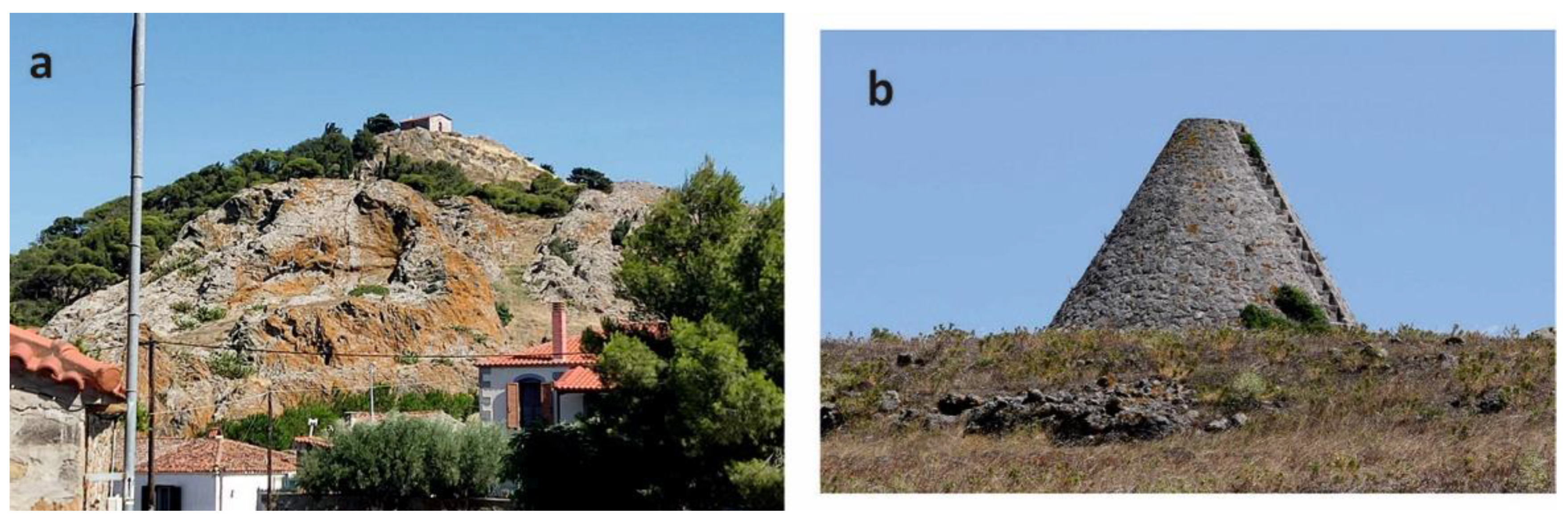
4.2.8. Road “Geo-Archaeo-Route” 4: Myrina–Avlona–Mourtzouflos

Road Geo-Archaeo-Route 4 (Figure 10) starts from the Sanctuary of Artemis (C01; Table 4, Figure 3) located in the area of Avlonas of Myrina at the Porto Myrina Hotel. The site was functioning as a temple of the goddess Artemis for more than eight centuries during the Archaic, Classical and Hellenistic Periods [123]. The temple complex included a large central paved yard and a sanctuary. Three wells were providing the sanctuary with water and a rectangular room at the northwest end of the enclosure was most probably acting as a gathering place for the initiation of the ceremonies. The worship of the Tauric Goddess was implanted at an early time in Lemnos, and also in Vravron (Attica) and Crimea. The legend of the Tauric Artemis was associated with human sacrifice, related to a bloodthirsty bull-devourer goddess, featuring the Attic-Lemnian worship [124]. The site excavations revealed many artefacts and relics, including pottery, figurines, perfume containers, jewelry, etc., all of which are on display at the Archaeological Museum of Myrina. Interestingly, several figurines of a bull, found together with the remains of a sacrificed bull, further indicate the relation to the worship of the Tauric Goddess Artemis in Vravron Attica.
Following the route to the north, the visitor encounters the impressive Lava Dome at Avlonas Beach (G09; Table 3, Figure 3 and Figure 4), which belongs to the Myrina Unit consisting of the youngest lava domes and occasional flows with mainly dacitic composition and an age of 19.3 to 18.2 Ma [45].
Along the coastal road in the northwestern part of the island, the route comes across some unique Coastal Landforms in Aghios Ioannis (G07; Table 3, Figure 3, Figure 4 and Figure 14a,b) at the sandy beach of Aghios Ioannis near Kaspakas village. The outcropping landforms include spectacular sea stacks and tafoni forms of honeycomb weathering in volcanic rocks in the coastal zone of the Myrina volcanic Unit [46].
Nearby, the well-defined scarp of the important Active Fault of Kaspakas (G06; Table 3, Figure 3, Figure 4 and Figure 14c) marks the landscape, being one of the most famous faults on the island, as well as in the entire Aegean. It is a normal fault of about 11 km in length with a WNW–ESE strike and respective maximum expected earthquake magnitude of M6.4 [61]. It stands out for its well-defined fault scarp and polished fault mirrors, located at its westernmost tip, affecting mainly the volcanic basement during the Early Miocene [46,63]. In the area of Kaspakas, Aghios Ioannis Gorge (G04; Table 3, Figure 3 and Figure 4), the most important gorge of the island bearing a length of about 3 km is associated with the tectonic activity of the Kaspakas fault combined with the continuous water erosion. The Katsaitis stream flows within the Aghios Ioannis Gorge, creating at its end the Kaspakas Waterfall (G05) near the beach of Aghios Ioannis; the fast-flowing waters fall from a height of about 15 m forming cavities and small lakes on the rocky substrate that provide shelter for the local fauna of frogs, turtles, eels and crabs [79].
Further to the north, the Neroviglia Gorge (G03; Table 3, Figure 3 and Figure 4) with a length of about 1 km is located at the northwestern tip of the island, ending at a picturesque small sandy beach. Towards its end, the Road Geo-Archaeo-Route 4 roams to reach its final destination at the cape of Mourtzouflos. The cape forms the Lava Dome of Mourtzouflos (G01; Table 3, Figure 3, Figure 4 and Figure 14d), which belongs to the Katalakkon volcanic Unit, intruded in the sediments of the Fissini-Sardes Unit [46]. The Katalakkon volcanics are exposed along a NW–SE trending zone that extends to the south extremity of Cape Fakos and has been radiometrically dated at 20–21 Ma [45]. The Lava Dome of Mourtzouflos is connected to the rest of the island with a sandy isthmus, the impressive Tombolo of Mourtzouflos (G02; Table 3, Figure 3, Figure 4 and Figure 14d).

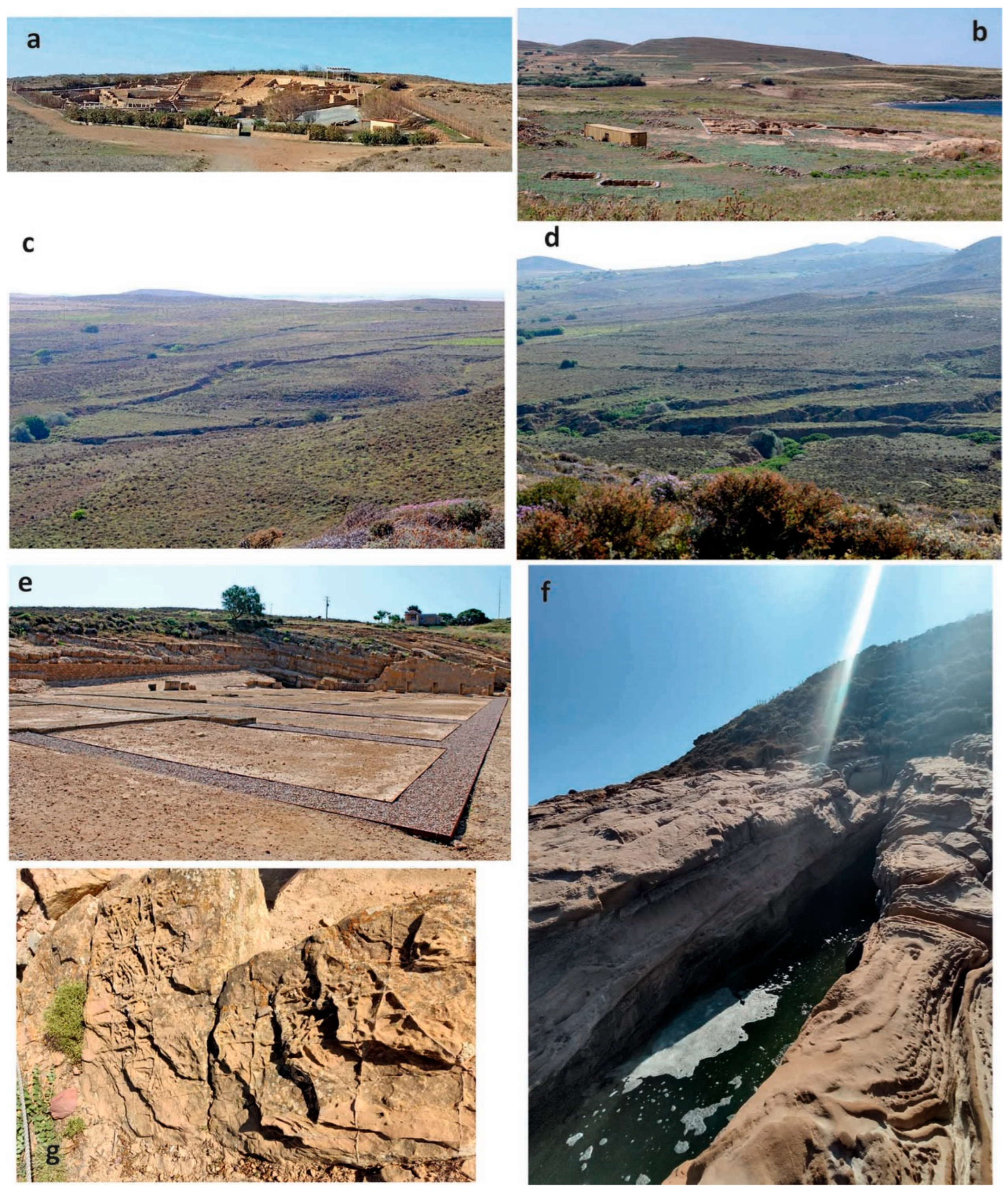
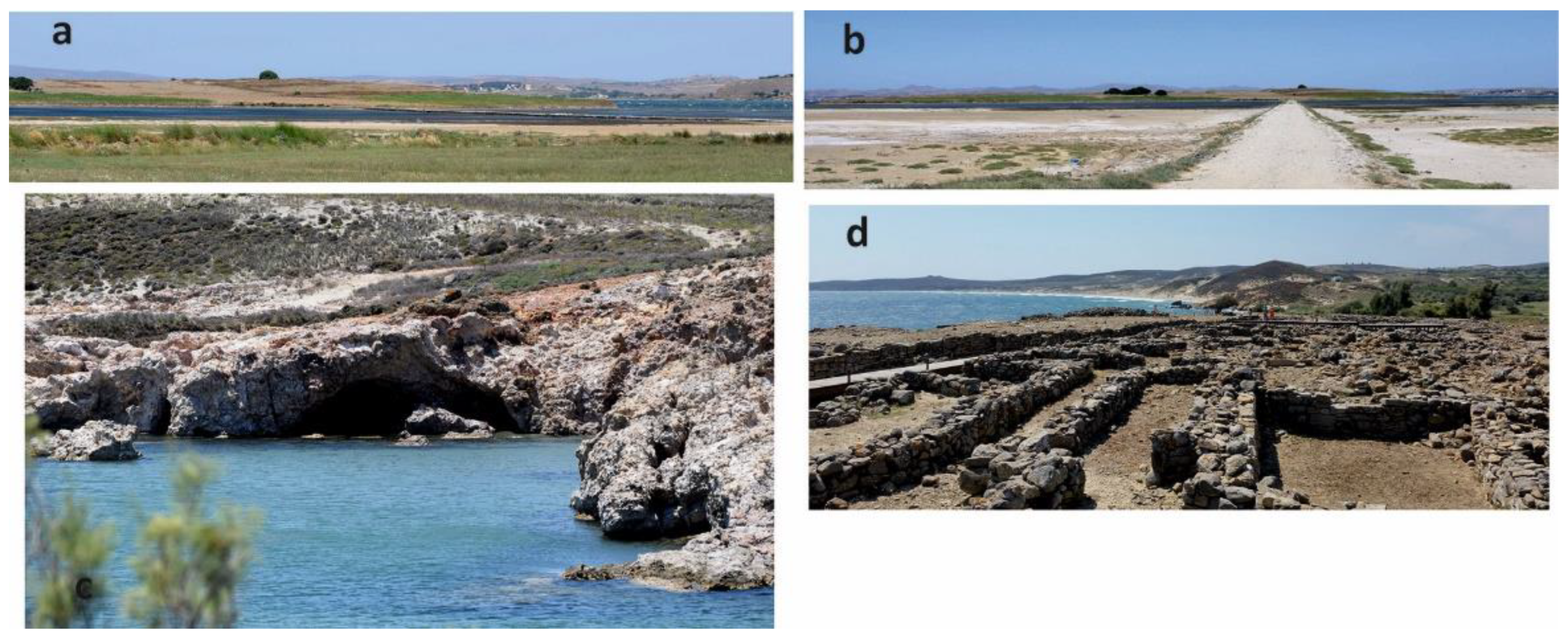
4.2.9. Road “Geo-Archaeo-Route” 5: Koukonisi–Poliochni

The route starts (Figure 10) from the Koukonisi islet wetland (W05; Table 3, Figure 3, Figure 4 and Figure 15a,b) that is part of the Natura 2000 network and includes extended salt flats developing between the islet and the coastal zone at the northeastern part of the Moudros Gulf [80]. The Prehistoric Settlement of Koukonisi (C08; Table 4, Figure 3) located in the area, was first discovered in 1992 during exploratory excavations and together with the other prehistoric sites on the island pinpoints the importance of Lemnos during the Bronze Age associated with its strategic location in the Aegean at the vicinity of the Dardanelles entrance and opposite Troy. Human presence is testified in Lemnos from around 12,000 BC, with signs of communities of fruit pickers, fishermen and hunters located at Ouriakos, on the eastern outer coast of the gulf of Moudros [30]. Early Bronze Age (3200–2000 BC) evidence with signs of early urbanization appear in the northeastern part of the Koukonisi islet, in the settlement area on the Koukonos plateau [125,126,127]. Τhe highest plateau on the islet had been artificially formed by continuous habitation for almost 2000 years, exhibiting Middle Helladic, Minoan and Mycenaean finds, with habitation lasting at least up to the Geometric and Archaic period. The Early Bronze Age figurines of human form made either of clay or of bone are thought to have been used in rituals and other ceremonies. The following Middle Bronze Age (2000–1650 BC) was marked by a hiatus detected in the habitation of the islet, being a period of prosperity for Koukonisi that was linked to the established trade activities with several Aegean regions [127]. During the Late Bronze Age (1650–1200 BC) early stages, the presence of Minoan civilization elements and culture coming from the southern Aegean strongly characterizes the southern part of the settlement. Later on, around the 14th century BC the Mycenaeans prevailed in Koukonisi in an attempt to maintain a balance of power in the Aegean area. Their installation was permanent, a fact that is attributed to the abundant appearance of Mycenaean pottery in the Koukonisi excavation site [127]; Mycenaean pottery has also been found in Hephaistia and other Lemnian sites, testifying the widespread Mycenaean presence on the island that proves commercial ties with Asia Minor.
Towards southeast, the Road Geo-Archaeo-Route 5 heads to the Cave of the Seal (G22; Table 3, Figure 3, Figure 4 and Figure 15c), east of the bay of Moudros, at Mikro Fanaraki beach. The cave is a result of coastal erosion mainly of pyroclastic rocks such as tuffs of the Romanou volcanic Unit [46] and took its name from the Monachus monachus seals.
Turning back to the west, the route passes through the area of the natural monument of the Petrified Forest of Moudros–Roussopouli–Kaminia (G23, 24; Table 3, Figure 3 and Figure 4) with silicified wood remains. The magmatic-hydrothermal systems that developed in the area about 20 million years ago provided the silica-enriched fluids that affected the tree trunks and plant remains, thus beginning the process of fossilization, the molecular replacement of organic plant matter by silica. The fossils that have been found in the area are: Cedroxylon sp., Cornoxylon pappi, Daphnogene polymorpha, Fagaceae, Lauraceae, Glyptostrobus europaeus, Laurinoxylon ehrendorferi, Phragmites sp., Pronephrium stiriacum, Pinoxylon parenchymatosum, Sabal sp., Sequoia abietina, as well as the roots, seeds and leaves of palm trees [85]. Most of the findings are exhibited in the old town hall of Moudros.
The route ends at the famous Prehistoric Settlement of Poliochni (C13; Table 4, Figure 3 and Figure 15d), which was discovered in the early 1930s by the Italian School of Archeology. The settlement is built on the east coast of Lemnos, in the area of Kaminia and was founded on a coastal terrace, in a coastal environment progressively flooded by the rising sea level [128]. Dated since the end of the Neolithic era and continuously developing mainly during the Early Bronze Age, Poliochni is considered to be one of the most ancient towns in Europe, preceding Troy I. Its development was due to the leading role it played in the transit trade with the islands of the northeastern Aegean, the coasts of Asia Minor, mainland Greece and the Cyclades islands. The evolution of the settlement is divided into seven periods, which are symbolized by colors [129,130]. The small settlement of circular huts of the “black period” (3700–3200 BC) has evolved into a larger and partially fortified settlement of rectangular elongated houses during the “cyan period” (3200–2700 BC). The “green period” (2700–2400 BC) is marked by population increases and a developed road network in contrast to the settlement shrink of the “red period” (2400–2200 BC) that nevertheless displayed the first monumental palaces. During the “yellow period” (2200–2100 BC), the settlement is associated with the Troy II [129] and is featured by important buildings. The irreversible destruction of the settlement took place in 2100 BC, when an earthquake struck Lemnos [131]. The following “brown” and “violet” (2000–1200 BC) periods are decline periods for the settlement associated with the rivalry with Troy.

5. Synthesis and Conclusions

Overall, Lemnos Island displays an authentic natural environment also rich in religious, archaeological, historical and cultural heritage, offering the opportunity for new, alternative forms of tourism that favor authentic experiences and a connection to local communities, thus setting the foundations for sustainable rural development in a geoethical perspective.
The final result of the quantitative assessment of the selected geosites combined with the distribution of the cultural sites on the island reveals the potential perspectives of the island for the development of “Geo-Archaeo-Routes” on Lemnos Island, towards a holistic geotouristic approach. In this way, the identification of even small-scale areas of interest is made possible, which can now be implemented in a broader network of touristic sites of the island to demonstrate in the most efficient way the linkages between local cultural context, archaeological monuments, biodiversity hotspots, landscapes and geological heritage.
In the present study, we propose “Geo-Archaeo-Routes” as authentic paths, a kind of time-capsules that integrate the geological features of the deep past of Lemnos Island together with the cultural archaeological and historical elements of the human societal imprints of the recent past, both being embodied in the modern natural geomorphological landscape. The involved sites are examples of mixed cultural–natural heritage providing cases where either geoheritage acts as an added value to the cultural heritage or vice versa [132].
Under this concept, the hiking “Geo-Archaeo-Route1 takes the geotourists from 19 million years ago when the volcanic rocks of the Myrina Unit were formed, to the Late Neolithic–Early Bronze age when these rocks were used as building stones for the Prehistoric Settlement of Myrina and later on, at the 13th century BC, for the “Cyclopean” walls of Myrina Castle, constructed by the Thessalians Minyans on the Lava Dome of Myrina. Out of the highlights of hiking “Geo-Archaeo-Route2, Panagia Kakkaviotissa Church of the 14th century AD, built in a large cavity shaped on the Lava Dome of Kakkavo volcanic rocks of 19 million years in age, further verifies the concept that natural rock formations and landforms often represent locations of religious or spiritual significance [15,132]. The Petrified Forest of Lemnos, with floristic evidence of about 20 million years in age, is scattered over a large part of Lemnos Island, comprising an important element of several “Geo-Archaeo-Routes”, enabling the geotourists to realize a totally different landscape for that time interval, with extended forests of coniferous trees petrified after extended volcanic eruptions. This experience has an apparent geoethical value as it provides the public with the opportunity to understand the consequences of potential natural hazards and also to raise awareness about the need for fossil preservation. The inactive Volcanic Crater of Moschylos, linked to the Greek god of fire and volcanoes God Hephaestus, in the hiking “Geo-Archaeo-Route3 and the Cave of Philoctetes in road “Geo-Archaeo-Route2 are typical cases of geomythology, a type of intangible heritage [132]. The hiking “Geo-Archaeo-Route3 offers one more travel in time at the geosite of Terra Lemnia, a weathered volcanic tuff clay of 20 million years in age that has been widely used as a medicine, particularly against the plague in medieval Europe. The modern landscape of Alyki Lake within hiking “Geo-Archaeo-Route4 keeps well hidden a rather complicated paleoenvironmental evolution of the coastal plain, providing evidence of the ancient shoreline (5100–1040 BC) to be located 500 m in front of the present-day shoreline, thus enabling geo-education about the hazard of sea level rise. In the same line, the Inland Sand Dunes of Gomati, a unique desert environment in the whole of Europe, along the road “Geo-Archaeo-Route1, present a perfect geo-educational example for the hazard of aridification and desertification in the current times of global warming. The Ancient Quarry of Hephaistia in road “Geo-Archaeo-Route2 represents an interface of geoheritage and cultural heritage [132], while the Pyramid of Lemnos in road “Geo-Archaeo-Route3 declares the early 20th century historical imprint on the natural environment. On the other hand, the temple of the Tauric Goddess and the road paved with volcanic stones from the 19-million-year-old yard of the Sanctuary of Artemis in road “Geo-Archaeo-Route4, imply the link between Lemnos and Crimea in the Black Sea, from the Archaic period. The prominent scarp of the Active Fault of Kaspakas not only marks the landscape of western Lemnos, but provides an excellent geoethical opportunity to contribute to the history of science and offer the public the scientific knowledge concerning the geology of the whole North Aegean to also raise awareness about the seismic hazards (e.g., [132]). The Prehistoric Settlement of Koukonisi at the vicinity of the homonymous wetland within “Geo-Archaeo-Route5 further verifies the development of Lemnos during the Bronze Age, while increasing the public awareness for sustainable environmental management. Finally, the Poliochni settlement, considered as one of the oldest towns in Europe, takes the visitors back not only to the late Neolithic age, but even as old as more than 20 million years ago, when the area was experiencing intense volcanic activity, as the building stones of the site mostly come from the surrounding Romanou volcanic Unit.
This study resulted in the extensive documentation and assessment based on the scientific literature and evaluation criteria of 46 geosites on Lemnos Island. All of them have been integrated with 12 cultural sites in 9 hiking and road “Geo-Archaeo-Routes” designed to serve the visitors in the best way, covering a wide range of topics also associated with good accessibility, safety and adequately available information. The proposed “Geo-Archaeo-Routes” have been followed and mapped in the field. Afterwards, all data were imported in the G.I.S. ArcMap 10.4 software to produce the relevant maps. Both hiking and road routes are proposed to follow the already existing dirt and paved roads network, the starting points being large villages and/or sites of ample interest so that besides hiking where feasible, they can be realized by any means of transport (car, bike, local transport, bus, etc.) in a holistic geotouristic approach.
As a next step, there will be an effort to make the touristic operators, local authorities and society of the island interested in the promotion of the proposed “Geo-Archaeo-Routes” to the touristic audience. In parallel, technology and innovation and a bridging approach between the cultural and creative sectors will be applied for the construction of story maps and 3D models that will be used as inputs for Augmented Reality/Virtual Reality (AR/VR) applications or even for the production of 3D prints at various scales. By transforming the natural and cultural touristic experience into an AR/VR product, we may transfer natural beauty, past civilizations and the history of Lemnos to people from all over the world, providing an opportunity to take part in socially, historically and culturally immersive virtual tours.
In all cases, there will be a particular effort concerning the geo-educational part; namely, coaching the touristic masses to behave according to the geoethical values and to be conscious about the preservation of the unique Lemnos geoenvironment.

Author Contributions

Conceptualization, M.V.T., N.F. and A.S.; methodology, M.V.T., N.F. and A.S.; software, E.V., T.T. and E.S.; validation, M.V.T., N.F., A.O. and A.S.; formal analysis, M.V.T., N.F. and A.O.; investigation, M.V.T., N.F., O.K. and A.O.; resources, M.V.T., N.F. and A.O.; data curation, N.F.; writing—original draft preparation, M.V.T. and N.F.; writing—review and editing, M.V.T., T.T. and E.S.; visualization, T.T., E.V., E.S. and O.K.; supervision, M.V.T.; project administration, M.V.T. and N.F. All authors have read and agreed to the published version of the manuscript.

Funding

This research received no external funding.

Data Availability Statement

The data presented in this study are available on request from the corresponding author.

Conflicts of Interest

The authors declare no conflict of interest.

References

  1. Dowling, R.K. Global Geotourism—An Emerging Form of Sustainable Tourism. Czech J. Tour. 2014, 2, 59–79. [Google Scholar] [CrossRef]
  2. Theodosiou, E.; Fermeli, G.; Koutsouveli, A. Our Geological Heritage; Kalidoskopio Publications: Athens, Greece, 2006. [Google Scholar]
  3. Stürm, B. Geotop. Grundzüge einer Begriffsentwicklung und Definition. Materialien 1993, 1, 13–14. [Google Scholar]
  4. Ielenicz, M. Geotope, Geosite, Geomorphosite. Ann. Valahia Univ. Târgovişt. Geogr. Ser. 2009, 9, 7–22. [Google Scholar]
  5. Reynard, E.; Panizza, M. Geomorphosites: Definition, assessment and mapping. Geomorphol. Reli. Process. Environ. 2005, 11, 177–180. [Google Scholar] [CrossRef]
  6. Triantaphyllou, M. Greek caves and touristic development. Bull. Speleol. Soc. Greece 1992, 20, 28–76. [Google Scholar]
  7. Skentos, A. Geosites of Greece: Record, Schematic, Geological Regime and Geotouristic Assessment; National and Kapodistrian University of Athens: Athens, Greece, 2012. [Google Scholar]
  8. Skentos, A.; Triantaphyllou, M. Registration and tourism assessment of Greek geosites using G.I.S. techniques. In Proceedings of the 32nd International Geographical Congress, Cologne, Germany, 26–30 August 2012. IGU 2012. [Google Scholar]
  9. Pica, A.; Fredi, P.; Del Monte, M. The ernici mountains geoheritage (Central Apennines, Italy): Assessment of the geosites for geotourism development. Geoj. Tour. Geosites 2014, 14, 193–206. [Google Scholar]
  10. Ruban, D.A. Geotourism—A geographical review of the literature. Tour. Manag. Perspect. 2015, 15, 1–15. [Google Scholar] [CrossRef]
  11. Ólafsdóttir, R.; Tverijonaite, E. Geotourism: A systematic literature review. Geosciences 2018, 8, 234. [Google Scholar] [CrossRef]
  12. Newsome, D.; Dowling, R.; Leung, Y.F. The nature and management of geotourism: A case study of two established iconic geotourism destinations. Tour. Manag. Perspect. 2012, 2–3, 19–27. [Google Scholar] [CrossRef]
  13. Fassoulas, C.; Zouros, N. Evaluating the influence of Greek Geoparks to the local communities. Bull. Geol. Soc. Greece 2017, 43, 896. [Google Scholar] [CrossRef]
  14. Dowling, R.; Newsome, D. Handbook of Geotourism; Edward Elgar Publishing Ltd.: Cheltenham, UK, 2018. [Google Scholar]
  15. Gordon, J.E. Geoheritage, geotourism and the cultural landscape: Enhancing the visitor experience and promoting geoconservation. Geosciences 2018, 8, 136. [Google Scholar] [CrossRef]
  16. Bithas, K. A bioeconomic approach to sustainable development: Incorporating ecological thresholds within intergenerational efficiency. Sustain. Dev. 2020, 28, 772–780. [Google Scholar] [CrossRef]
  17. Antić, A.; Peppoloni, S.; Di Capua, G. Applying the Values of Geoethics for Sustainable Speleotourism Development. Geoheritage 2020, 12, 73. [Google Scholar] [CrossRef]
  18. Peppoloni, S.; Di Capua, G. The Meaning of Geoethics. In Geoethics: Ethical Challenges and Case Studies in Earth Sciences; Wyss, M., Peppoloni, S., Eds.; Elsevier: Amsterdam, The Netherlands, 2015; pp. 3–14. [Google Scholar]
  19. Silvia Peppoloni; Giuseppe Di Capua Geoethics and geological culture: Awareness, responsibility and challenges. Ann. Geophys. 2012, 55. [CrossRef]
  20. Peppoloni, S.; Di Capua, G. The significance of geotourism through the lens of geoethics. In Proceedings of the EGU General Assembly 2022, Vienna, Austria, 23–28 May 2022; p. 1756. [Google Scholar]
  21. May, V. Integrating the geomorphological environment, cultural heritage, tourism and coastal hazards in practice. Suppl. Geogr. Fis. Din. Quat. 2008, 31, 187–194. [Google Scholar]
  22. Grunwald, A. The imperative of sustainable development: Elements of an ethics of using geo-resources responsibly. In Geoethics: Ethical Challenges and Case Studies in Earth Sciences; Wyss, M., Peppoloni, S., Eds.; Elsevier: Amsterdam, The Netherlands, 2015; pp. 26–35. [Google Scholar]
  23. Velitzelos, E.; Mountrakis, D.; Zouros, N.; Soulakelis, N. Atlas of the Geological Monuments of the Aegean Sea; Publications of the Ministry of the Aegean: Aegean, Greece, 2002. [Google Scholar]
  24. Zafeiropoulos, G.; Drinia, H.; Antonarakou, A.; Zouros, N. From geoheritage to geoeducation, geoethics and geotourism: A critical evaluation of the Greek region. Geosciences 2021, 11, 381. [Google Scholar] [CrossRef]
  25. Spyrou, E.; Triantaphyllou, M.V.; Tsourou, T.; Vassilakis, E.; Asimakopoulos, C.; Konsolaki, A.; Markakis, D.; Marketou-Galari, D.; Skentos, A. Assessment of Geological Heritage Sites and Their Significance for Geotouristic Exploitation: The Case of Lefkas, Meganisi, Kefalonia and Ithaki Islands, Ionian Sea, Greece. Geosciences 2022, 12, 55. [Google Scholar] [CrossRef]
  26. Drinia, H.; Tripolitsiotou, F.; Cheila, T.; Zafeiropoulos, G. The Geosites of the Sacred Rock of Acropolis (UNESCO World Heritage, Athens, Greece): Cultural and Geological Heritage Integrated. Geosciences 2022, 12, 330. [Google Scholar] [CrossRef]
  27. Official Government Gazette of the Hellenic Republic. Issue 2 no 1278 2000. Free access: The National Printing House of Greece. Available online: http://www.et.gr (accessed on 7 May 2023).
  28. Official Government Gazette of the Hellenic Republic. Issue 4 no208 2002. Free access: The National Printing House of Greece. Available online: http://www.et.gr (accessed on 7 May 2023).
  29. Kakalis, E. Report on the ornithological evaluation of area G132 Lakes Chortarolimni and Alyki, Moudros Bay, Diapori Swamp, Fakos Peninsula; Athens, Greece, 2009. [Google Scholar]
  30. Efstratiou, N. The final Paleolithic hunting camp of Ouriakos on the island of Lemnos. Eurasian Prehistory 2014, 11, 75–96. [Google Scholar]
  31. Zouros, N.; Soulakellis, N.; Valiakos, I.; Grimpylakos, G.; Lamprakopoulos, A.; Panidou, P.; Papadopoulou, E.; Tataris, G. Geological and Geomorphological Heritage Sites in Lemnos Island, Greece and their Geotourism Potential. Bull. Geol. Soc. Greece 2021, Sp. Pub. 8, 64–68. [Google Scholar]
  32. Natural History Museum of Lesvos Petrified Forest Geomonuments and Geosites of Lemnos. Available online: https://www.lemnosgeomonuments.gr/en/ (accessed on 10 February 2023).
  33. Panizza, M.; Piacente, S. Geomorphosites: A bridge betwenn scientific research, cultural integration and artistic suggestion. Alp. Mediterr. Quat. 2005, 18, 3–10. [Google Scholar]
  34. Coratza, P.; Gauci, R.; Schembri, J.; Soldati, M.; Tonelli, C. Bridging Natural and Cultural Values of Sites with Outstanding Scenery: Evidence from Gozo, Maltese Islands. Geoheritage 2016, 8, 91–103. [Google Scholar] [CrossRef]
  35. Possamai, F.V. Nature and Culture: Genesis of an Obsolete Dichotomy. Philos. Study 2013, 3, 836–842. [Google Scholar]
  36. Roston, H.I. Nature and culture in environmental ethics. In the Proceedings of the Twentieth World Congress of Philosophy; Brinkmann, K., Ed.; Philosophy Documentation Center: Bowling Green, OH, USA, 1999; pp. 151–158. [Google Scholar]
  37. Sauer, C.O. The morphology of landscape. Publ. Geogr. 1925, 2, 19–54. [Google Scholar]
  38. Reynard, E.; Giusti, C. The Landscape and the Cultural Value of Geoheritage. In Geoheritage; Elsevier: Amsterdam, The Netherlands, 2018; pp. 147–166. [Google Scholar]
  39. Dimopoulos, T.; Dimitropoulos, G.; Georgiadis, N. The Land Use Systems of Lemnos Island. Terra Lemn. Rep. 2018. terra lemnia project. Available online: https://med-ina.org/wp-content/uploads/2020/12/Terra-Lemnia-1.1.1-Land-Use-Systems-of-Lemnos-Dec-2018.pdf (accessed on 10 February 2023).
  40. Sidiropoulou, M. Geomorphological and Palaeogeographical Evolution of Lemnos Island (NE Aegean), the Last 6000 Years; Harokopeion University: Athens, Greece, 2016. [Google Scholar]
  41. Panitsa, M.; Snogerup, B.; Snogerup, S.; Tzanoudakis, D. Floristic investigation of Lemnos island (NE Aegean area, Greece). Willdenowia 2003, 33, 79–105. [Google Scholar] [CrossRef]
  42. Thomas, K.; Thanopoulos, R.; Knüpffer, H.; Bebeli, P.J. Plant genetic resources of Lemnos (Greece), an isolated island in the Northern Aegean Sea, with emphasis on landraces. Genet. Resour. Crop Evol. 2012, 59, 1417–1440. [Google Scholar] [CrossRef]
  43. Municipality of Limnos. Available online: www.limnos.gov.gr/files/007/epitropidiabouleusis/epixsxed2015-19.docx (accessed on 10 February 2023).
  44. Broggi, M.F. The “wetland island” of Lemnos (Greece): Herpetofauna and nature conservation. Herpetozoa 2018, 30, 169–178. [Google Scholar]
  45. Innocenti, F.; Manetti, P.; Mazzuoli, R.; Pertusati, P.; Fytikas, M.; Kolios, N. The geology and geodynamic significance of the Island of Limnos, North Aegean Sea, Greece. Neues Jahrb. Geol. Paläontologie 1994, 1994, 661–691. [Google Scholar] [CrossRef]
  46. Innocenti, F.; Manetti, P.; Mazzuoli, R.; Pertusati, P.; Fytikas, M.; Kolios, N.; Vougioukalakis, G.E.; Androulakakis, N.; Critelli, S.; Caracciolo, L. Geological map (scale 1:50,000) of Lemnos island (Greece): Explanatory notes. Acta Vulcanol. 2009, 21, 123–134. [Google Scholar] [CrossRef]
  47. Roussos, N.; Katsaounis, A.; Tsaila-Monopoli, S.; Ioakeim, X.; Karadasi, S.; Davi, E. Geological Map of Lemnos Island; Institute of Geology and Mineral Exploration: Athens, Greece, 1993. [Google Scholar]
  48. Caracciolo, L.; Critelli, S.; Innocenti, F.; Kolios, N.; Manetti, P. Unravelling provenance from Eocene-Oligocene sandstones of the Thrace Basin, North-east Greece. Sedimentology 2011, 58, 1988–2011. [Google Scholar] [CrossRef]
  49. Maravelis, A.; Zelilidis, A. Paleoclimatology and Paleoecology across the Eocene/Oligocene boundary, Thrace Basin, Northeast Aegean Sea, Greece. Palaeogeogr. Palaeoclimatol. Palaeoecol. 2012, 365–366, 81–98. [Google Scholar] [CrossRef]
  50. Kostopoulou, S.; Maravelis, A.G.; Zelilidis, A. Biostratigraphic analysis across the Eocene-Oligocene boundary in the southern Hellenic Thrace basin (Lemnos Island, north Aegean Sea). Turk. J. Earth Sci. 2018, 27, 232–248. [Google Scholar] [CrossRef]
  51. Papp, A. Erla uterungen zur Geologie der Insel Lemnos. Ann. Géol. Pays Hell. 1953, 5, 1–25. [Google Scholar]
  52. Papanikolaou, D.; Triantaphyllou, M. New stratigraphic data of the Lemnos volcano-sedimentary sequence and correlations with the Thrace Basin. 15th International Congress of the Geological Society of Greece. Bull. Geol. Soc. Greece 2019, Sp. Pub. 7, GSG2019-240. [Google Scholar]
  53. Papanikolaou, D. Geotectonic evolution of the Aegean. Bull. Geol. Soc. Greece 1993, 28, 33–48. [Google Scholar]
  54. Papanikolaou, D. Tectonostratigraphic models of the Alpine terranes and subduction history of the Hellenides. Tectonophysics 2013, 595–596, 1–24. [Google Scholar] [CrossRef]
  55. Papanikolaou, D.I. The Geology of Greece; Regional Geology Reviews; Springer International Publishing: Cham, Switzerland, 2021; ISBN 978-3-030-60730-2. [Google Scholar]
  56. Pe-Piper, G.; Piper, D.J.W. The Igneous Rocks of Greece. The Anatomy of an Orogen; Gebruder Borntraeger: Berlin, Germany, 2002. [Google Scholar]
  57. Pavlopoulos, K.; Fouache, E.; Sidiropoulou, M.; Triantaphyllou, M.; Vouvalidis, K.; Syrides, G.; Gonnet, A.; Greco, E. Palaeoenvironmental evolution and sea-level changes in the coastal area of NE Lemnos Island (Greece) during the Holocene. Quat. Int. 2013, 308–309, 80–88. [Google Scholar] [CrossRef]
  58. Fytikas, M.; Giuliani, O.; Innocenti, F.; Manetti, P.; Mazzuoli, R.; Peccerillo, A.; Rita, F.; Villari, L. Neogene Volcanism of the Northern and Central Aegean region. Ann. Géol. Pays Hell. 1979, 30, 106–129. [Google Scholar]
  59. Pe-Piper, G.; Piper, D.J.W.; Koukouvelas, I.; Dolansky, L.M.; Kokkalas, S. Postorogenic shoshonitic rocks and their origin by melting underplated basalts: The Miocene of Limnos, Greece. Geol. Soc. Am. Bull. 2009, 121, 39–54. [Google Scholar] [CrossRef]
  60. Pavlides, S.; Mountrakis, D.; Kilias, A.; Tranos, M. The role of strike-slip movements in the extensional area of Northern Aegean (Greece). Ann. Tecton. 1990, 4, 196–211. [Google Scholar]
  61. Pavlides, S.; Tsapanos, T.; Zouros, N.; Sboras, S.; Koravos, G.; Chatzipetros, A. Using active fault data for assessing seismic hazard: A case study from NE Aegean Sea, Greece. In Proceedings of the Earthquake Geotechnical Engineering Satellite Conference XVIIth International Conference on Soil Mechanics & Geotechnical Engineering, Alexandria, Egypt, 2–3 October 2009; pp. 1–14. [Google Scholar]
  62. Tranos, M.D. Faulting of Lemnos Island; a mirror of faulting of the North Aegean Trough (Northern Greece). Tectonophysics 2009, 467, 72–88. [Google Scholar] [CrossRef]
  63. Chatzipetros, A.; Kiratzi, A.; Sboras, S.; Zouros, N.; Pavlides, S. Active faulting in the north-eastern Aegean Sea Islands. Tectonophysics 2013, 597–598, 106–122. [Google Scholar] [CrossRef]
  64. Pavlides, S.B.; Tranos, M.D. Structural characteristics of two strong earthquakes in the North Aegean: Ierissos (1932) and Agios Efstratios (1968). J. Struct. Geol. 1991, 13, 205–214. [Google Scholar] [CrossRef]
  65. Bakalis, C. Lemnos: Urban Structure, Social Restructuring, Migratory Networks and Urban Reflections in the 19th and 20th Century; University of Aegean, School of Social Sciences: Aegean, Greece, 2007. [Google Scholar]
  66. Lanaridis, P.; Salaha, M.-J.; Tzourou, I.; Tsoutsouras, E.; Karagiannis, S. Volatile compounds in grapes and wines from two Muscat varieties cultivated in Greek islands. OENO One 2002, 36, 39. [Google Scholar] [CrossRef]
  67. Makris, G. Wine Surveyor. Available online: https://winesurveyor.weebly.com/tour1801.html (accessed on 15 February 2023).
  68. Fassoulas, C.; Mouriki, D.; Dimitriou-Nikolakis, P.; Iliopoulos, G. Quantitative Assessment of Geotopes as an Effective Tool for Geoheritage Management. Geoheritage 2012, 4, 177–193. [Google Scholar] [CrossRef]
  69. Grandgirard, V. Methode pour la realisation d’un inventaire de geotopes geomorphologiques. UKPIK Cah. l’Institute Geogr. l’Universite Fribg. 1995, 10, 121–137. [Google Scholar]
  70. Rivas, V.; Rix, K.; Francés, E.; Cendrero, A.; Brunsden, D. Geomorphological indicators for environmental impact assessment: Consumable and non-consumable geomorphological resources. Geomorphology 1997, 18, 169–182. [Google Scholar] [CrossRef]
  71. Zouros, N.C. Geomorphosite assessment and management in protected areas of Greece Case study of the Lesvos island—Coastal geomorphosites. Geogr. Helv. 2007, 62, 169–180. [Google Scholar] [CrossRef]
  72. Reynard, E.; Fontana, G.; Kozlik, L.; Pozza, C.S. A method for assessing «scientific» and «additional values» of geomorphosites. Geogr. Helv. 2007, 62, 148–158. [Google Scholar] [CrossRef]
  73. Archontidou, A. Archaeological Museum of Lemnos, Myrina. Available online: http://odysseus.culture.gr/h/1/gh152.jsp?obj_id=3413 (accessed on 10 February 2023).
  74. Privitera, S. Hephaestia on Lemnos and the Mycenean presence in the islands of the northeastern Aegean. In Emporia: Aegeans in the Central and Eastern Mediterranean, Proceedings of the 10th International Agean Conference, Athens Italian School of Archaeology, Athens, Italy, 14–18 April 2004; Université de Liège, Histoire de l’art et Archéologie de la Grèce Antique: Liège, Belgium, 2005; pp. 227–236. [Google Scholar]
  75. Tsolaki, D. Prehistoric Settlement of Myrina. Available online: http://odysseus.culture.gr/h/3/gh351.jsp?obj_id=7461 (accessed on 10 February 2023).
  76. Avgerinou, P. The settlement at Myrina: A preliminary assessment. In Poliochni and the Early Bronze Age in the Aegean; Scuola Italiana di Atene: Athens, Greek, 1997; pp. 273–281. [Google Scholar]
  77. Ephorate of Antiquities of Lesvos The Medieval Castle of Myrina, Lemnos Island. Available online: https://www.efales.gr/sight/mesaioniko-kastro-myrinas-n-limnoy (accessed on 10 February 2023).
  78. Mattila, M.; Hadjigeorgiou, I. Conservation and management of fallow deer (Dama dama dama L.)on Lemnos Island, Greece. Turk. J. Vet. Anim. Sci. 2015, 39, 560–567. [Google Scholar] [CrossRef]
  79. Kousouris, T. A Recent Survey for the Small Natural Lakes in Greece with Their Features; Independently Published: Athens, Greece, 2016. [Google Scholar]
  80. WWF Greece Ygrotopio Islands—Database of the Greek Island Wetlands. Available online: https://www.ygrotopio.gr/general/search.php?lang=en&action=map (accessed on 15 February 2023).
  81. Gläser, L.; Grosche, A.; Voudouris, P.C.; Haase, K.M. The high-K calc-alkaline to shoshonitic volcanism of Limnos, Greece: Implications for the geodynamic evolution of the northern Aegean. Contrib. Mineral. Petrol. 2022, 177, 73. [Google Scholar] [CrossRef]
  82. Liapi, E. Panagia Kakaviotissa. Available online: https://stirouga.blogspot.com/2011/05/blog-post_23.html?m=1 (accessed on 15 February 2023).
  83. Hellenic Republic, Ministry of Tourism. Available online: https://mintour.gov.gr/meletes-pinakes/stoicheia-iamatikon-pigon/ (accessed on 20 February 2023).
  84. Aggelidis, Z.; Mitrakas, M. Results of the Chemical Analysis of a Sample of Therma Water; Faculty of Engineering, Aristotle University of Thessaloniki: Thessaloniki, Greece, 2005; Available online: http://users.sch.gr/dipap/analisi_neroy.htm (accessed on 20 February 2023).
  85. Velitzelos, D.; Bouchal, J.M.; Denk, T. Review of the Cenozoic floras and vegetation of Greece. Rev. Palaeobot. Palynol. 2014, 204, 56–117. [Google Scholar] [CrossRef]
  86. Süss, H.; Velitzelos, E. Lesbosoxylon gen. nov., eine neue Morphogattung mit dem Typus Lesbosoxylon ventricosuradiatum sp. nova aus dem Tertiär der Insel Lesbos, Griechenland. Feddes Repert. 2010, 121, 18–26. [Google Scholar] [CrossRef]
  87. Velitzelos, D.; Iamandei, S.; Iamandei, E.; Velitzelos, E. Palaeoxylotomical studies in the Cenozoic petrified forests of Greece. Part one—Palms. Acta Palaeobot. 2019, 59, 289–350. [Google Scholar] [CrossRef]
  88. Iamandei, S.; Iamandei, E.; Velitzelos, D.; Velitzelos, E. Palaeoxylotomical Studies In The Cenozoic Petrified Forests Of Greece. Part Two—Conifers. Acta Palaeontol. Rom. 2021, 65–111. [Google Scholar] [CrossRef]
  89. Luce, S.B. Archaeological News and Discussions. Am. J. Archaeol. 1941, 45, 283–301. [Google Scholar] [CrossRef]
  90. Photos-Jones, E.; Edwards, C.; Häner, F.; Lawton, L.; Keane, C.; Leanord, A.; Perdikatsis, V. Archaeological medicinal earths as antibacterial agents: The case of the Basel Lemnian sphragides. Geol. Soc. London Spec. Publ. 2017, 452, 141–153. [Google Scholar] [CrossRef]
  91. Venieri, D.; Gounaki, I.; Christidis, G.E.; Knapp, C.W.; Bouras-Vallianatos, P.; Photos-Jones, E. Bridging the Gaps: Bole and Terra Sigillata as Artefacts, as Simples and as Antibacterial Clays. Minerals 2020, 10, 348. [Google Scholar] [CrossRef]
  92. Loupou, A. Church of Agios Georgios in Repanidi. Available online: http://odysseus.culture.gr/h/2/gh251.jsp?obj_id=1670 (accessed on 10 February 2023).
  93. Georgiadis, Ν.Μ.; Bergmeier, Ε.; Dimitropoulos, G.; Κairis, O.; Kakalis, Ε.; Κosmas, Κ.; Meyer, S.; Bembeli, P.; Panitsa, Μ.; Perdikis, D.; et al. The Natural Environment of Lemnos with Emphasis to Biodiversity and Soil. 2020. Available online: https://med-ina.org/wp-content/uploads/2021/11/Terra-Lemnia-Biodiversity-and-Soil-Synthesis-Report-GR.pdf (accessed on 10 February 2023).
  94. Katsadorakis, G.; Paragamian, Κ.; Georgiadis, N. The status of the wetlands in the island of the Aegean Sea. In Proceedings of the Panhellenic Conference «Biosciences in the 21st century», Athens, Greece, 2006. [Google Scholar]
  95. Sidiropoulou, M.; Fouache, E.; Pavlopoulos, K.; Triantaphyllou, M.; Vouvalidis, K.; Syrides, G.; Greco, E. Geomorphological evolution and paleoenveronment reconstruction in the northeastern part of Lemnos Island (North Aegean Sea). Aegaeum 2014, 37, 49–55. [Google Scholar]
  96. Triantaphyllou, M.V.; Gogou, A.; Dimiza, M.D.; Kostopoulou, S.; Parinos, C.; Roussakis, G.; Geraga, M.; Bouloubassi, I.; Fleitmann, D.; Zervakis, V.; et al. Holocene Climatic Optimum centennial-scale paleoceanography in the NE Aegean (Mediterranean Sea). Geo. Mar. Lett. 2016, 36, 51–66. [Google Scholar] [CrossRef]
  97. Davis, R.A.; Fitzegerald, D.M. Beaches & Coasts; Blackwell Science Ltd.: Oxford, UK, 2004. [Google Scholar]
  98. Soukis, K.; Koufosotiri, E.; Stournaras, G. Special landforms on Tinos Island: Spheroidal weathering “Tafoni” forms. In Proceedings of the 3rd International Scientific Symposium of Protected areas and Natural Monuments, Molyvos, Greece, 13–15 July 1998. [Google Scholar]
  99. Evelpidou, N.; Leonidopoulou, D.; Vassilopoulos, A. Tafoni and Alveole Formation. An Example from Naxos and Tinos Islands. In Natural Heritage from East to West; Evelpidou, N., Figueiredo, T., Mauro, F., Tecim, V., Vassilopoulos, A., Eds.; Springer: Berlin Heidelberg, Germany, 2010; pp. 35–42. ISBN 978-3-642-01576-2. [Google Scholar]
  100. Gkioles, N.; Pallis, G. Atlas of the Christian Monuments of the Aegean. From the Early Christian Years to the Fall of Constantinople; General Secreteriat of the Aegean & Island Policy: Athens, Greece, 2014. [Google Scholar]
  101. WWF Greece WWF Greece, LEM037-Sourladika. Available online: http://www.oikoskopio.gr/ygrotopio/gallery/view-gallery.php?action=view_images&alb_category_id=57&alb_album_title=LEM037-Σουρλάδικα/Sourladika&alb_album_id=461&lang=en_US (accessed on 10 March 2023).
  102. Erosion Structures—Trigies Cape. Available online: https://www.lemnosgeomonuments.gr/en/simeio/erosion-structures-trigies-cape/ (accessed on 10 March 2023).
  103. Georgopoulos, P. Environmental Impact Study of the Shooting Range in the Wider Falakro Area of the Municipality of Atsiki on the Island of Lemnos; University of the Aegean: Lesvos, Greece, 2010. [Google Scholar]
  104. Chatzidimitriou, A.; Pantekas, T.; Papanastasiou, A.; Davas, Ε.; Kaltsidis, A. Spatial and Residential Organization Plan of An Open City D.E. Atsiki Municipality of Lemnos—Strategic Environmental Impact Study; 2016, Municipality of Lemnos. Available online: https://limnos.gov.gr/files/keimenob1fasi.pdf (accessed on 10 March 2023).
  105. Greco, E. For an archaeological phenomenology of the society of Hephestia (Lemnos) from the Late Bronze Age to the end of Archaism. Ann. Archeol. Estoria Antica. 2018, 25, 11–31. [Google Scholar]
  106. Sanctuary of the Great Goddess at the Archaelogical Site of Hephaistia. Available online: http://odysseus.culture.gr/h/2/gh251.jsp?obj_id=19985 (accessed on 10 March 2023).
  107. Archontidou, A.; Limnaiou, Ε.; Panatsi, A.; Pylarinou, Ν. Myrina of the Early Bronze Age; Ministry of Culture and Sports, Ephorate of Antiquities: Lemnos, Greece, 2004.
  108. Hephaistia. Lemnos Island Travel Guide. Available online: https://www.mylemnos.gr/greece/ifaistia.html (accessed on 10 March 2023).
  109. Kokkorou-Alevra, G.; Poupaki, E.A.E.; Chatzikonstantinou, A. Corpus of Ancient Quarries; Section of Archaeology and History of Art, National and Kapodistrian University of Athens: Athens, Greece , 2014. [Google Scholar]
  110. Beschi, L. Culto e riserva delle acque nel santuario arcaico di Efestia. Annu. Sc. Archeol. Atene Mission. Ital. Oriente 2006, 83, 95–234. [Google Scholar]
  111. Ministry of Education and Religious Affairs Culture and Sports Odysseus. Available online: http://odysseus.culture.gr/index_en.html (accessed on 10 March 2023).
  112. Campbell, J. The Mysteries; Princeton University Press: Princeton, NJ, USA, 1978. [Google Scholar]
  113. Arikas, K.; Voudouris, P. Hydrothermal alteration and mineralizations of magmatic rocks in the southern Rhodope Massif. Acta Vulcanol. 1998, 10, 353–365. [Google Scholar]
  114. Voudouris, P.; Skarpelis, N. Epithermal gold-silver mineralizations in Perama (Thrace) and Lemnos. Bull Geol Soc Greece 1998, 32, 125–135. [Google Scholar]
  115. Voudouris, P.; Alfieris, D. New porphyry—Cu±Mo occurrences in the north-eastern Aegean, Greece: Ore mineralogy and epithermal relationships. In Mineral Deposit Research: Meeting the Global Challenge, Proceedings of the Eighth Biennial SGA Meeting, Beijing, China, 18—21 August 2005; Springer: Berlin/Heidelberg, Germany, 2005; pp. 473–476. [Google Scholar]
  116. Papoulis, D.; Tsolis-Katagas, P. Formation of alteration zones and kaolin genesis, Limnos Island, northeast Aegean Sea, Greece. Clay Min 2008, 43, 631–646. [Google Scholar] [CrossRef]
  117. Fornadel, A.P. Mineralogical, Petrological, Stable Isotope and Fluid Inclusion Studies of the Palea Kaval Reduced Intrusion-Related and the Transitional Fakos Porphyry Cu-Mo to Epithermal Au-Te Ore Systems; Iowa State University: Ames, IA, USA, 2010. [Google Scholar]
  118. Anyfadi, A.; Parcharidis, I.; Sykioti, O. Hidrothermal alteration zones detection in Limnos island, through the application of remote sensing. Bull. Geol. Soc. Greece 2016, 50, 1595–1604. [Google Scholar]
  119. Museum of Maritime Trandition and Sponge Fishing MUSEUM of Maritime Trandition and Sponge Fishing. Available online: https://www.facebook.com/profile.php?id=100069949720331 (accessed on 20 March 2023).
  120. Voudouris, P.; Velitzelos, D.; Velitzelos, E.; Thewald, U. Petrified wood occurrences in western Thrace and Limnos island: Mineralogy, geochemistry and depositional environment. Bull. Geol. Soc. Greece 2007, 40, 238–250. [Google Scholar] [CrossRef]
  121. Ioannou, A. The Oddities of Lemnos. Available online: https://www.geografikoi.gr/limnos-perierga-1/ (accessed on 10 March 2023).
  122. Claven, J. The Mysterious Lighthouse of Lemnos and Its Connection with Australia. Available online: https://neoskosmos.com/el/2020/06/11/features/o-mystirios-faros-tis-limnou-kai-i-syndesi-tou-me-tin-afstralia/ (accessed on 10 March 2023).
  123. Pappa, M. Sanctuary of Artemis at Avlonas in Myrina. Available online: http://odysseus.culture.gr/h/2/gh251.jsp?obj_id=2489 (accessed on 10 March 2023).
  124. Farnell, L.R. The Cults of the Greek States, vol. II.; Clarendon Press: Oxford, UK, 1896. [Google Scholar]
  125. Boulotis, C. Koukonisi on Lemnos: Reflections on the Minoan and Minoanising evidence. In The Minoans in the Central, Eastern and Northern Aegean—New Evidence; Macdonald, C.F., Hallager, E., Niemeier, W.-D., Eds.; Monographs of the Danish Institute at Athens: Athens, Greece, 2009; Volume 8, pp. 175–218. [Google Scholar]
  126. Boulotis, C. Koukonisi (Lemnos), un site portuaire florissant du Bronze Moyen et du début du Bronze Récent dans le Nord de l’Égée. In Mesohelladika: La Gréce Continentale au Bronze Moyen, Colloque International Organisé par l’École Française d’Ahènes en Collaboration avec l’American School of Classical Studies at Athens et le Netherlands Institute in Athens, Athènes, EFA/Cotsen Hall; Philippa-Touchais, A., Touchais, G., Voutsaki, S., Wright, J., Eds.; École française d’Athènes: Athens, Greece, 2010; pp. 891–907. [Google Scholar]
  127. Boulotis, C. The Prehistoric settlement of Koukonisi, Lemnos. Available online: https://www.archaiologia.gr/blog/2012/03/12/ο-προϊστορικός-οικισμός-στο-kουκονήσι/ (accessed on 10 March 2023).
  128. Vouvalidis, K.; Kapsimalis, V.; Tsourlos, P.; Koukousioura, O.; Almpanakis, K.; Czebreszuk, J.; Aidona, E.; Doani, S.; Vandarakis, D.; Dimou, G.-V. Ancient Poliochni Geoarchaeological Research: Its proximity to the sea and the possible location of an ancient harbor (North Aegean Sea, Greece). In Proceedings of the 10th International Conference on Geomorphology, Coimbra, Portugal, 12–16 September 2022; p. ICG2022-442. [Google Scholar]
  129. Brea, L.B. A Bronze Age house in Poliochni. Proc. Prehist. Soc. 1955, 21, 145. [Google Scholar]
  130. Kyriakopoulou, T. Archaeological site of Poliochni at Kaminia Area. Available online: http://odysseus.culture.gr/h/3/eh351.jsp?obj_id=2534 (accessed on 10 March 2023).
  131. Cultrato, M. Domestic architecture and public space in Early Bronze Age Poliochni (Lemnos). Br. Sch. Athens Stud. Build. Communities House, Settl. Soc. Aegean Beyond 2007, 15, 55–64. [Google Scholar]
  132. Pijet-Migoń, E.; Migoń, P. Geoheritage and Cultural Heritage—A Review of Recurrent and Interlinked Themes. Geosciences 2022, 12, 98. [Google Scholar] [CrossRef]
Figure 1. Map of the study area and location of the considered Aegean island of Lemnos.
Geosciences 13 00143 g001
Figure 2. Geological map of Lemnos Island and legend of the geological formations (modified from IGME map). The map shows the distribution of the main geological formations and faults.
Geosciences 13 00143 g002
Figure 3. Location of selected geosites on Lemnos Island.
Geosciences 13 00143 g003
Figure 4. Categorization of the assessed geosites according to the evaluation criteria of [7], on Lemnos Island.
Geosciences 13 00143 g004
Figure 5. Designed hiking georoutes for Lemnos Island.
Geosciences 13 00143 g005
Figure 6. Selected geosites on Lemnos Island, for coding see Figure 3. (a) Archaeological Museum (C03); (b,c) Lava Dome of Myrina Castle (G10); (d) Lava Domes at Evgatis Beach (G14).
Geosciences 13 00143 g006
Figure 7. Selected geosites on Lemnos Island, for coding see Figure 3. (a) Lava Dome of Kakkavo (G15); (b,c) Panagia Kakkaviotissa Church (C06); (d) Therma Springs (G11); (e) Profitis Ilias Lava Dome (G12).
Geosciences 13 00143 g007
Figure 8. Selected geosites on Lemnos Island, for coding see Figure 3. (a) Petrified trunk of Varos (G36); (b) Volcanic Crater of Moschylos (G35); (c) Church of Agios Georgios (C09).
Geosciences 13 00143 g008
Figure 9. Selected geosites on Lemnos Island, for coding see Figure 3. (a,b) Alyki Lake (W08); (c) Chortarolimni (W06).
Geosciences 13 00143 g009
Figure 10. Designed road georoutes for Lemnos Island.
Geosciences 13 00143 g010
Figure 11. Selected geosites on Lemnos Island, for coding see Figure 3. (a) The church of Zoodochos Pigi on the remnants of the Kotsinas Fortress (C12); (b) the statue of Maroula of Lemnos in the church yard (Kotsinas Fortress); (ce) Sedimentary Rocks of Faraklo (G34); (fh) Inland Sand Dunes of Gomati (G37); (i) detail of the sand from the dunes under a stereomicroscope: benthic foraminifera and a fragment of an echinoid spicule.
Geosciences 13 00143 g011
Figure 12. Selected geosites on Lemnos Island, for coding see Figure 3. (a) The Archaeological Site of Hephaistia (C11); (b) the Ancient Quarry of Hephaistia; (c,d) Rejuvenated Drainage of Neftina (G30); (e) Sanctuary of Kaveirion (C10); (f) Cave of Philoctetes (G31); (g) Honeycomb Weathering formations in Plaka (G29).
Geosciences 13 00143 g012
Figure 13. Selected geosites on Lemnos Island, for coding see Figure 3. (a) Lava Dome of Kondias (G17); (b) the Pyramid of Lemnos (G21) at the edge of the cape Punta.
Geosciences 13 00143 g013
Figure 14. Selected geosites on Lemnos Island, for coding see Figure 3. (a,b) Coastal Landforms in Agios Ioannis (G07); (c) the active Fault of Kaspakas (G06) (photo courtesy of A. Chatzipetros); (d) the impressive Tombolo of Mourtzouflos (G02).
Geosciences 13 00143 g014
Figure 15. Selected geosites on Lemnos Island, for coding see Figure 3. (a,b) Koukonisi islet wetland (W05); (c) The Cave of the Seal (G22); (d) Prehistoric Settlement of Poliochni (C13).
Geosciences 13 00143 g015
Table 1. Population evolution of Lemnos for the last 100 yr and distribution of economic sectors, census 2011 (Source: Hellenic Statistical Authority).
Census YearPopulationEconomic Sectors
192019,642Geosciences 13 00143 i001
192823,611
194023,842
195124,018
196121,812
197117,367
198115,721
199117,645
200118,104
201116,992
202216,458
Table 2. Evaluation criteria for geosite assessment according to [7]. Quantifications in geodiversity refer to the number of different geological characteristics of each site; quantifications in rarity refer to the number of geosites on Lemnos Island featured by analogous geological features and quantifications in visibility refer to the number of locations on the island from which the geosite is visible.
12345
Geological HistorySmall
participation at local level
Moderate
participation at local level
Great
participation at local level
Moderate
participation at regional level
Great
participation at regional level
RepresentativenessNot at allLowMediumHighUnique
Geodiversity1<3<5<10>10
Rarity>20>10>5>2Unique
ConservationTotally damagedLowMediumHighIntact
EducationNot at all-Medium-High
History–ArchaeologyNot at allExisting—Low importanceMinor importanceModerate importanceGreat importance—Geohistoric site
ReligionNot at allExisting—Low importanceMinor importanceModerate importanceGreat importance—Geohistoric site
Visibility1234>4
Landscape DifferentiationNot at allLowMediumHighVery high
AccessibilityNot accessibleLowMediumHighVery high
Tourist InfrastructureNot at allLowMedium-High
Ecological ValueNot at all-Medium-High
Table 3. Lemnos Island geosites assessment, following the evaluation criteria of Table 2.
Location TypeFossil SitesNatural WetlandsArtificial Wetlands
NamePetrified Trunk of Profitis IliasPetrified Trunk of ParanisiaPetrified Forest of Lemnos (Tsimandria–Portiano)Petrified Forest of Lemnos (Moudros–Roussopouli–Kaminia)Petrified Forest of Lemnos (Romano–Varos)Petrified Trunk of VarosPetradi LakesDiapori SwampKoukonisi isletChortarolimniAsprolimniAlyki LakeSourladikaThanos ReservoirKontias Artificial Lake
Code NameG13G16G20G23, G24G26G36W01W03W05W06W07W08W09W02W04
Latitude39°53′20″ N39°50′47″ N39°52′11″ N39°52′09″ N39°55′22″ N39°55′48″ N39°50′21″ N39°51′36″ N39°53′00″ N39°54′05″ N39°55′08″ N39°56′43″ N39°57′30″ N39°51′35″ N39°53′19″ N
Longitude25°07′13″ E25°08′40″ E25°11′15″ E25°18′05″ E25°16′40″ E25°15′24″ E25°04′57″ E25°10′15″ E25°16′08″ E25°20′04″ E25°22′34″ E25°22′21″ E25°16′04″ E25°07′00″ E25°09′00″ E
Geological History444444211223212
Representativeness444444222324222
Geodiversity115551222223312
Rarity224442223334433
Conservation554445344544434
Education333533111133111
History–Archaeology111211111111111
Religion111111111111111
Visibility224445555555555
Landscape Differentiation113331445545355
Accessibility555555555555555
Tourist Infrastructure113532111133111
Ecological Value555555555555555
Total Score2.692.693.543.923.543.002.622.622.773.003.083.542.852.622.85
Location TypeVolcanic StructuresTectonic Structures
NameLava Dome of MourtzoufloMetal-Bearing Zone of SardesLava Domes at Avlonas BeachLava Dome of Myrina CastleTherma SpringsLava Dome of Profitis IliasLava Domes at Evgatis BeachLava Dome of KakkavoLava Dome of SkoposMetal-Bearing Zones of FakosLava Dome of KontiasVolcanic Vein of Portianou“Terra Lemnia”Volcanic Crater of MosychlosKaspakas WaterfallActive Fault of Kaspakas
Code NameG01G08G09G10G11G12G14G15G17G18G19G21G32G35G05G06
Latitude39°59′07″ N39°55′47″ N39°53′45″ N39°52′35″ N39°54′19″ N39°53′58″ N39°50′42″ N39°52′04″ N39°49′32″ N39°48′46″ N39°52′00″ N39°52′58″ N39°55′58″ N39°55′44″ N39°56′16″ N39°55′59″ N
Longitude25°02′23″ E25°08′58″ E25°03′40″ E25°03′20″ E25°07′18″ E25°07′51″ E25°06′14″ E25°06′28″ E25°10′59″ E25°11′28″ E25°08′21″ E25°12′20″ E25°16′37″ E25°16′13″ E25°03′58″ E25°04′19″ E
Geological History4344444443444434
Representativeness3234333532335423
Geodiversity1321111214114121
Rarity1311211513135413
Conservation4544344445444345
Education1115311511135311
History–Archaeology1115111511145411
Religion1112111511121111
Visibility5155555551515455
Landscape Differentiation5255355552525445
Accessibility3555555535555554
Tourist Infrastructure1125511311211121
Ecological Value1111311111113351
Total Score2.382.232.693.623.002.542.544.152.382.312.622.624.003.152.772.69
Location TypeGeomorphological and Sedimentary Structures
NameTombolo of MourtzouflosNeroviglia GorgeAgios Ioannis GorgeCoastal Geoforms in Agios IoannisCave of the SealTafoni Forms in KavalarisCoastal Sand Dunes of AlykiSandy Arm of AlykiHoneycomb Weathering in PlakaHydrographic Network of NeftinaCave of PhiloctetesSurficial Rectangular Forms in TrigiesSedimentary Rocks of FarakloInland Sand Dunes of Gomati
Code NameG02G03G04G07G22G25G28G29G29G30G31G33G34G37
Latitude39°59′04″ N39°58′27″ N39°56′42″ N39°55′27″ N39°51′11″ N39°53′22″ N39°56′27″ N39°55′51″ N40°00′28″ N39°58′48″ N39°58′46″ N39°59′19″ N39°59′38″ N39°59′28″ N
Longitude25°02′45″ E25°03′29″ E25°04′40″ E25°04′09″ E25°14′27″ E25°22′09″ E25°23′05″ E25°22′31″ E25°24′16″ E25°21′14″ E25°20′26″ E25°16′18″ E25°14′28″ E25°07′47″ E
Geological History33333333333344
Representativeness32232223323355
Geodiversity22243222322234
Rarity42232314442455
Conservation55445544555544
Education11311111113131
History–Archaeology11111111111111
Religion11111111111111
Visibility55555443555455
Landscape Differentiation54455334435344
Accessibility33554445444455
Tourist Infrastructure11253122113133
Ecological Value33333355333335
Total Score2.852.542.853.312.922.542.542.922.922.693.082.693.543.62
Table 4. Lemnos Island cultural sites.
NameCode NameType
Sanctuary of ArtemisC01Archaeological sites
Myrina Prehistoric SettlementC02Archaeological sites
Archaeological Museum of LimnosC03Museums
Myrina CastleC04Castles and fortresses
Portianou Folklore MuseumC05Museums
Panagia Kakkaviotissa ChurchC06Churches
Museum of Maritime Tradition and Sponge-Fishing of Nea KoutaliC07Museums
Koukonisi Prehistoric SettlementC08Archaeological sites
St. George’s ChurchC09Churches
Kaveirion Archaeological SiteC10Archaeological sites
Hephaestia Archaeological SiteC11Archaeological sites
Kotsinas FortressC12Castles and fortresses
Disclaimer/Publisher’s Note: The statements, opinions and data contained in all publications are solely those of the individual author(s) and contributor(s) and not of MDPI and/or the editor(s). MDPI and/or the editor(s) disclaim responsibility for any injury to people or property resulting from any ideas, methods, instructions or products referred to in the content.

