
The “Perfect Village” Model as a Result of Research on Transformation of Plant Cover—Case Study of the Puchaczów Commune

Department of Landscape Architecture, Faculty of Horticulture and Landscape Architecture, University of Life Sciences in Lublin, Głęboka St. 28, 20-612 Lublin, Poland
*
Author to whom correspondence should be addressed.
Sustainability 2022, 14(21), 14479; https://doi.org/10.3390/su142114479
Submission received: 8 September 2022
/
Revised: 7 October 2022
/
Accepted: 31 October 2022
/
Published: 4 November 2022
Abstract
:Contemporary efforts to create “ideal” rural areas are carried out in accordance with the concept of sustainable development. It should be emphasized that in the process of planning the directions of development of rural areas, the economic factor is very often placed above the ecological one. It is the conditions of the natural environment that should form the basis for their shaping. Research on natural resources, including vegetation, makes it possible to recognize the quality of the landscape and adapt future directions of its transformations to the existing condition. The main aim of the article is to present the model of the “perfect village”—the principles of shaping natural systems that support sustainable development. The territorial scope of the research covered the Puchaczów commune. It is a rural area with an additional industrial character. The guidelines of the “perfect village” model have been organized hierarchically, taking into account the scope of the planned activities. There are three basic types of them: protection, strengthening and reconstruction of the vegetation. Another equally important goal is to present the spatial transformations taking place in the commune’s landscape and to generate a forecast of its possible development in 2050. The authors also performed a simulation of land cover taking into account the guidelines of the “perfect village”. The research was carried out using the QGIS 2.18 program and the MOLUSCE plugin. Both forecasts were subject to a comparative analysis. Research has shown that by applying the principles of shaping the natural system of the Puchaczów commune presented in the article, it is possible to inhibit the pressure of anthropogenic factors on the natural environment.
1. Introduction
Since the dawn of time, people have been shaping the landscape that surrounds them, trying to create the best place to live for themselves. An example of such searches can be the concepts of ideal cities characteristic of the Renaissance [1], arranged in geometric systems [2]. Nowadays, we are dealing with the pursuit of excellence in space planning, but it has a completely different dimension than in the case of Alberti or Leonardo da Vinci, because we are increasingly trying to be guided by the principle of sustainable development. Today, the concepts of “perfect” areas are not reserved only for cities, but also include rural areas which are created according to the principles of sustainable development too. It is worth mentioning here that the implementation of the principles of sustainable development in rural areas is a highly problematic issue in the world [3,4,5,6] and in Poland [7,8]. This is due not only to the need to reduce the disproportions existing between villages and cities in the socio-economic sphere, resulting from, inter alia, high unemployment and aging of the society [9,10], but also due to the significant dependence of the countryside on natural conditions, influencing, among others, agricultural production, which remains the dominant function of these areas [11] and related to it specific environmental protection needs and specific landscape features [12,13,14,15,16,17]. Rural areas are undergoing a huge transformation during this time, from food production regions to multi-functional zones. If this process is not properly prepared, it can lead to enormous spatial and environmental problems. In line with the prevailing paradigm, the concept of a “perfect village” appearing in the title of the article should therefore be understood as a “sustainable village”, a rural commune in which the negative effects of economic activity are eliminated so that they do not pose a threat to specific natural resources, landscape or cultural heritage in the future while taking into account “the needs of the present generation without compromising the ability of future generations” [18].
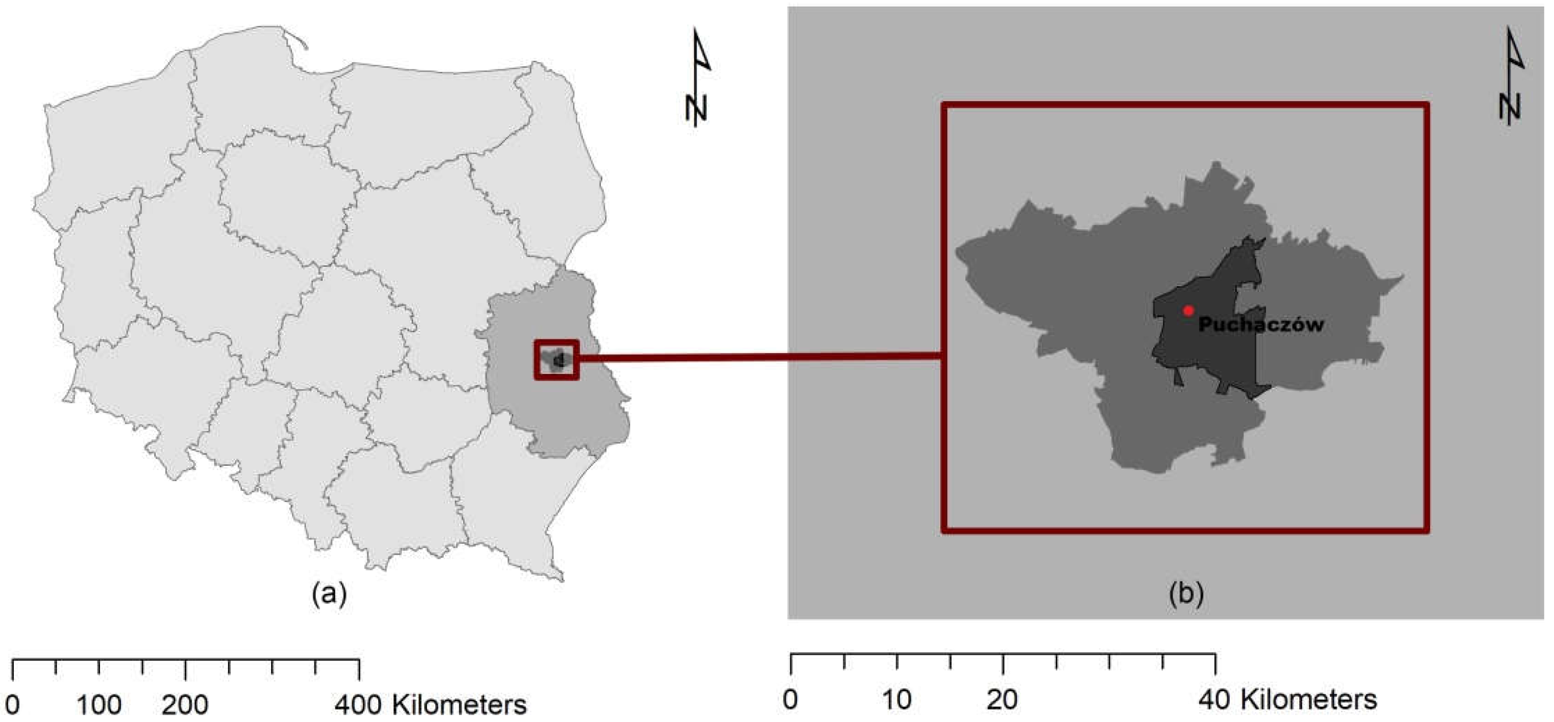
The territorial scope of the research covered the Puchaczów commune within its current administrative borders. It is a Polish rural commune located in the central part of the Lubelskie Voivodeship, in the Łęczna poviat. Due to the presence of hard coal deposits, apart from the dominant agricultural function in the second half of the 20th century, the mining industry developed. It is now the main element driving the economic development of the described area, and at the same time, it is the factor that has the greatest impact on its landscape.
According to Baster and Litwin, the Polish landscape planning system, which is almost identical to European standards, is clearly divided into a 4-step method of operation: inventorying the existing landscape resources, their valorization and definition of general guidelines, and the design process itself [17]. This system is also reflected in the way rural areas are shaped. It should be noted that the issues discussed in this article focus on the last two stages. The priority objective of the article is to present the model of a “perfect village” presenting specific guidelines for the reconstruction of vegetation, supporting the shaping of rural areas with an additional industrial character in accordance with the principles of sustainable development. Another equally important goal is to generate spatial forecasts of further transformations taking place in the commune’s landscape and to compare them with a simulation taking into account the above-mentioned guidelines.
The authors would like to emphasize that the article is a summary of several years of research into the vegetation of rural areas and presents the possibilities of their use in the process of developing planning documents, and indirectly shaping the natural environment, in particular in the case of polyfunctional areas.
2. Literature Review
It is common in the literature to define rural areas as opposed to cities. Following the above-mentioned paradigm, the authors decided to start their deliberations on the “ideal village” by outlining the idea of ideal cities. Visions of ideal cities have appeared in every epoch, from antiquity to modern times, but the concept is most often associated with the Renaissance [1]. In 1465, the ideal city was described by Antonio Averulino, also known as Filarete, in the treatise Trattato di Architettura. The author in his work presented the theoretical concept of the city of Sforzinda (Figure 1), which was never realized. The layout of the foundation was based on the plan of a star inscribed in a circle. The city plan thus constructed was ideal in itself, as it referred to a figure symbolizing infinity [19].
It is worth emphasizing here that the Renaissance “ideal cities” are not only theoretical, but also implemented assumptions that fit into this concept, e.g., Palmonova or Zamość.
Compared to cities, the medieval and renaissance idealism of villages was not related to the symbolic aspect, and the spatial arrangement did not reflect divinity, infinity. It was rather a functional layout of the space, facilitating, above all, the acquisition and storage of food from agricultural production.
The 19th century brought changes in the social, natural and aesthetic spheres, and earlier urban thoughts ceased to meet the needs of the new reality driven by the industrial revolution. People wanted to live in a classless, equal society, which was also reflected in the concepts of ideal cities. At the turn of the 19th and 20th centuries, urban theories emerged, which most strongly emphasized the need to strengthen the city’s relationship with nature. One of the most important is the vision of the garden city by Ebenezer Howard. This concept was also reflected in practice; an example may be the city of Letchworth, founded in 1903. Moreover, the vision of a garden city was the basis for the formation of modern urban ideas, i.e., green cities and eco-cities, becoming one of the foundations of the New Urbanism movement [19].
Nowadays, striving for the “ideal” space is implemented through the concepts of sustainable development, which also applies to rural areas.
One of the concepts behind the pursuit of “perfect” rural areas is the idea of a Smart Village [21,22,23]. As defined by the ENRD, smart villages are a community living in rural areas that leverage local strengths and opportunities as well as innovative solutions to improve quality of life. The concept is based on a participatory way of implementing strategies to improve economic, social and environmental conditions, in particular through digitization [24]. The idea of smart villages is very often not limited to the village level, but also applies to neighboring regions [25]. Initiatives undertaken within its framework may require integrated actions between local authorities and urban centers [26].
As already emphasized, an important role in the development of smart villages is played by information and communication technologies (ICT), which can significantly reduce the problems of rural areas resulting from their remoteness and low population density. They enable instant communication and access to electronic services and thus generate new opportunities [21,27,28,29].
It is worth noting, however, that information and communication technologies and their elements are not necessary in the process of building smart villages, and the most important issue is to adapt the proposed solutions to the local and regional specificity [30].
Another view related to the perception of “ideal villages” is presented by the Model Village initiative, which is now popular in India [31,32]. In the context of socio-economic and political conditions, Indian model villages are to be a response to the increasing marginalization of rural areas. They are part of the Holistic Rural Development Program (HVDP) conducted under Saansad Adarsh Gram Yojana (SAGY) [33]. The idea of model villages is to transform selected areas into self-sufficient, sustainable and equitable settlement units, so that they constitute a development model for the remaining rural areas [31]. Attempts to implement the concept were undertaken in the villages of Hiware Bazar, Ankapur and Kumbalangi, among others [32].
Shaping sustainable rural areas is directly related to the search for new pro-ecological solutions, which are extremely important in the current times of climate change. The “climate crisis” (understood as global warming of the climate and its effects) that has affected us in recent years, combined with a pandemic, and now a European resource crisis, should be a warning signal for area managers, including local governments. There is no other solution for the future than measures to protect the environment, even at the cost of economic losses [34]. The agricultural sector, which is the basic form of development in rural areas, generates a significant emission of gases which influence the climate. In turn, climatic threats, i.e., an increase in temperature and a reduced amount of rainfall, reduce the quality, quantity and stability of agricultural production (including in Europe and Asia) [35,36]. The above is connected with the necessity to adapt and transform the existing agricultural systems [36]. One way to do this may be Climate Smart Agriculture (CSA), as a new direction of economic development based on the principles of sustainable agriculture [14,37]. It includes the integrated management of water, soil and ecosystems at the landscape scale [38]. The implementation of CSA practices significantly improves the profitability of farms and reduces the likelihood of crop failures [37,39].
Regardless of the difference in the perception of the “ideal village” presented above, its shaping is not possible without prior environmental research, including transformations of plant cover, which allow for the recognition of the landscape condition and adaptation of future directions of its changes to the existing natural resources with the principles of sustainable development.
3. Study Area
The Puchaczów commune is located in the central part of the Lubelskie Voivodeship, in the Łęczna poviat (Figure 2). Both the geological structure and geomorphology have a huge impact on its current development, because they determine the presence of hard coal deposits within it. Therefore, it is not surprising that the breakthrough time for the development of the commune was the establishment of the first coal mine in the region in 1975. The mine was built in the vicinity of the village of Bogdanka, on previously farmed lands. The exploitation of this raw material began in the 1980s and resulted in transformations in the economic sphere of the area [40]. The commune, from a typically rural, mono-functional one, has turned into an area with new opportunities. The existence of a coal mine in the region created a new development potential, resulting in the location of various types of production plants in its vicinity, thus increasing the number of jobs [41]. The Bogdanka S.A. mine operating in the region currently has (as of 2022) four coal mining concessions, including deposits located within the administrative boundaries of the Puchaczów commune: Bogdanka, the “Puchaczów V” mining area (concession number 5/2009), K3, “Stręczyn” (concession number 3/2014). The validity of the concession expires in the year 2031, 2046. In the area of the Puchaczów commune, there is also a small fragment of the “Ostrów” deposit located in the Ludwin mining area (license number 6/2017) [42]. The phase of decommissioning coal will concern the next generations of “decision makers”, but it should already be the subject of care and appropriate preparations, including the reconstruction of the vegetation. Despite the undeniably positive effects of the mine’s operation on the development of the economic sphere, the exploitation of coal caused a number of changes in the natural environment [43].
3.1. Characteristics of the Potential and Actual Vegetation of the Puchaczów Commune
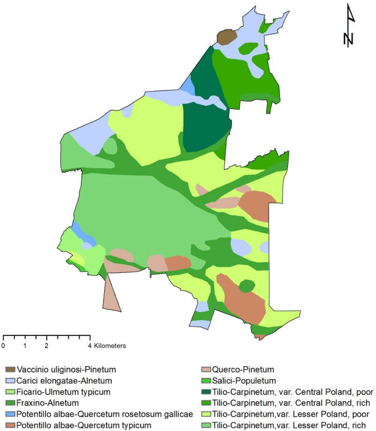
By analyzing the map of potential natural vegetation of Poland [44], it should be noted that Tilio-Carpinetum var. Lesser Poland of the rich or poor type is clearly dominant in the area of the commune. These plant communities have the form of large-area patches located in the central and eastern part of the Puchaczów commune. Subcontinental Tilio-Carpinetum patches are located in the northern part of the described area. The low ash-alder riparian forest Fraxino Alnetum has a stripy character, and its occurrence is conditioned by moist soils and river valleys. Fragments of the Central European alder Carici elongatae-Alnetum can be found at the northern border of the commune. It is a community typical of marshy habitats with periodically high levels of stagnant water and different soil fertility. In addition to the above-mentioned groups of potential vegetation communities, the following can also be noted in the Puchaczów commune: Ficario-Ulmetum typicum, Potentillo albae-Quercetum typicum and Pino-Quercetum (Figure 3).
In the years 2019–2021, the authors of the article conducted research to identify the actual vegetation of the Puchaczów commune (Annex 1 in Supplementary Materials). The phytocoenoses recorded in the described area are dominated by groups of synanthropic plants (ruderal and segetal) and semi-natural communities. Based on the analysis of the floristic composition, it was found that the vegetation in the commune is predominantly built up of apophytes, which constitute 72.5% of all identified species (Figure 4). The percentage of alian species is 27.5%, of which 17% are archaeophytes, 8.8% kenophytes, 1.1% ergasyophytophytes, and 0.6% ephemerophytes. Foreign plants occur mainly within agricultural landscapes—near arable fields and farm buildings. The lowest number of them was found in the areas of meadows. It should be stated that plants of foreign origin occur most often in the areas with the greatest anthropogenicity transformation.
3.2. Valorization of the Landscape of the Puchaczów Commune
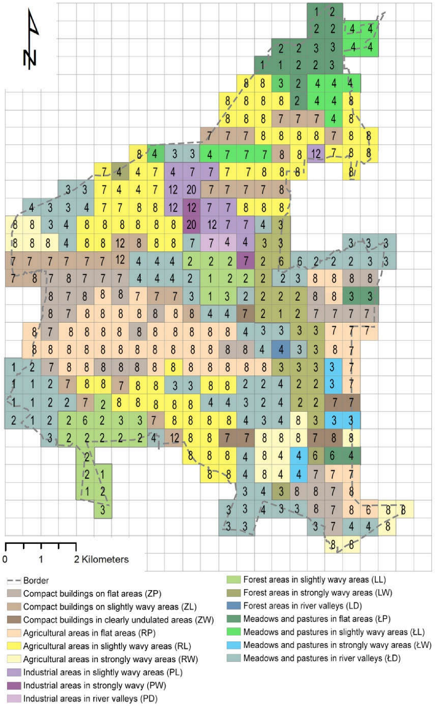
In order to develop the principles of shaping the “ideal village” and to indicate the places related to the scope of individual activities planned within the model, it was necessary to perform landscape valorization by comparing the actual vegetation with the potential one. One of the first stages of valorization was the separation of research units. Their detailed description is presented in a separate article [45]. Based on the adopted method, 16 research units, homogeneous in terms of the way of use and shape of the research units, were determined. Then, the actual vegetation in the Puchaczów commune was determined. For this purpose, data from the analysis of phytosociological elevés and the orthophotomap (geoportal) current for 2020 were used. Individual research fields (squares with dimensions of 500 × 500 m) were assigned an anthropization class (Figure 5), which made it possible to calculate the average valuation value for each unit and area of the entire commune. The classes of anthropization of vegetation and the valuation scale were adopted from Plit (Table 1) [46].
As the research has shown, the most transformed structure of vegetation occurs in the industrial zone, and the least in forest areas, meadows and pastures. The valuation values of anthropogenic vegetation reflect the level of anthropogenic transformations of the landscape and thus characterize the degree of its naturalness. The average valuation value of anthropization classes for the area of the entire Puchaczów commune is 5.7. This means that the studied area is characterized by a relatively low transformation of the flora. Despite the presence of agricultural and industrial land development, the impact of which on the flora is the greatest, the Puchaczów commune has a high natural potential, which should constitute the basis for indicating further directions of its development, e.g., in terms of introducing tourist functions.
4. Materials and Methods
A diagram showing the sequence of research and the scope of the study included in this article is presented in Figure 6.
4.1. Data Sources
In the research presented in the article, publicly available, rash cartographic materials were used: orthophotomaps valid for the years 2012 and 2020, Digital Elevation Model (DEM) and data on the records of the city, streets and addresses of the Puchaczów commune. The materials were obtained using WFS and WMS services using ArcGIS 10.8.1 [47] and QGIS 2.18 [48]. All maps have been reduced to a common coordinate system PUWG 1992, EPSG: 2180. When developing the model of a “perfect village”, information on actual vegetation was also used from original in situ studies (phytosociological relevés) and conclusions from the valorization of the landscape based on the plant cover analysis.
4.2. Guidelines for the Formation of a “Perfect Village”
The guidelines of the “perfect village” model were organized hierarchically, taking into account the scope of planned activities and the degree of transformation of plant communities (Table 2). Three basic types of activities have been distinguished: protection, strengthening and reconstruction of natural systems. The protection of plant systems is to protect the existing communities so as to limit and inhibit the pressure of elements that threaten their proper functioning. The areas with the lowest degree of anthropization of vegetation are envisaged for protection—the final communities or similar. These are areas important in terms of their environmental functions—they are ecological patches, areas characterized by the highest biological activity [43]. Strengthening natural structures is possible in the case of communities slightly transformed as a result of anthropopressure. It takes into account the introduction of new plantings adapted both to the form of development of the area on which they are located and to the habitat. The areas requiring the implementation of this type of guideline are characterized by an average degree of anthropization of the vegetation, ranging from 3 to 6 valuation values (Table 1). It is worth mentioning that these areas play the role of ecological patches or corridors of both regional and supra-local importance [43]. Therefore, their proper management is of particular importance for the improvement of the functioning of the entire natural system of the commune and the spatially related zones. The areas most transformed by human activity are distinguished by the synanthropization of plant cover. Its result is, among others, the displacement of native species by anthropophytes [46], replacement of stenotopic plants with narrow ecological tolerance with eurytopic species [49] and the disappearance of natural plant communities in favor of anthropogenic communities. In these areas, it is necessary to reconstruct the existing natural systems by taking into account special-purpose plantings, e.g., in post-industrial areas.
The described model of the “perfect village” has also been presented graphically in the form of a diagram appropriate for the planning scale of the study. The model presents the area of the commune divided into zones according to the above-mentioned types of guidelines, along with an indication of the proposed directions for the transformation of plant cover. All planned activities are aimed at ensuring the continuity of the scattered systems of rural greenery and linking them with the open landscape, so as to take full advantage of the development opportunities of the Puchaczów commune resulting from natural conditions.
4.3. Forecasting Changes in the Landscape and Comparing Them with the Model of the “Ideal Village”
The forecast of changes taking place in the landscape of the Puchaczów commune required the preparation of diagrams presenting the state of land cover (development) from various periods of time. For this purpose, orthophotos showing the coverage of the area in 2012 and 2020 were used. The obtained data was interpreted in the ArcGIS 10.8.1 software [47] using the supervised classification method using the maximum likelihood tool. There are 6 main categories of terrain management: forests and trees, grasslands, agricultural area, development areas, industry and surface waters (Table 3). The distinguished units were additionally checked with the starting materials (orthophotomaps), and in the case of incorrect matching, they were manually assigned to the appropriate group. The schemas generated in this way were saved in the raster form with the cell size 10.
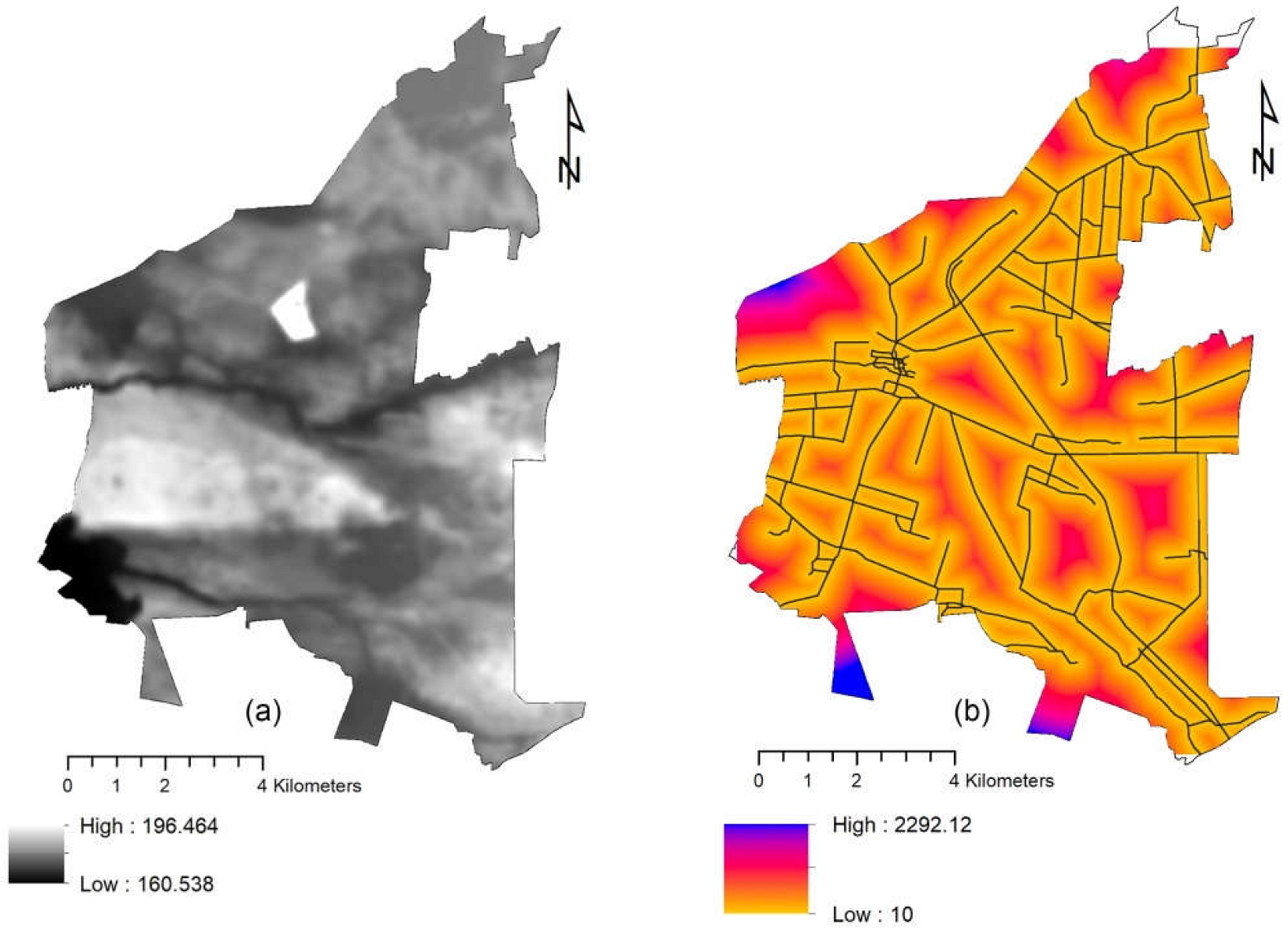
Then, using the QGIS 2.18 [45] program and the MOLUSCE plugin [50], an analysis of land cover changes in the presented time frames was performed. The independent variables used in the analysis were the Digital Elevation Model (DEM) and the distance from roads (Figure 7). These elements were selected due to their significant impact on the development of rural areas, and thus on the flora of the commune. The presented factors are commonly used in this type of analysis, because they allow repeatable data to be obtained describing the physical features of the terrain [51,52]. The MOLUSCE plugin uses four forecasting methods: Artificial Neural Network (ANN), Multi Criteria Evaluation (MCE), Weights of Evidence (WOE) and Logistic Regression (LR). In the presented study, the logical regression method was used (LR). The value of the maximum number of iterations was 100 and the neighborhood was 1 px. The change in land cover in the years 2012–2020 made it possible to prepare a forecast for the development of the commune for 2050, i.e., the period after the expiry of two concessions (No. 5/2009, No. 3/2014).
For the purposes of the study, a simulation of land cover was also generated, taking into account the principles of shaping the vegetation presented in the model of the “ideal village”. It was assumed that these guidelines would be introduced in the commune within 10 years. The work methodology was the same as in the case previously described. The land cover scheme for 2012 was compared with the “perfect village” model, and a possible landscape development forecast for 2050 was developed using the MOLUSCE plugin [50]. Both simulations were then subjected to comparative analysis in terms of land cover forms.
5. Results
5.1. The “Perfect Village” Model
In the Puchaczów commune, we are currently dealing with the intensive development of two branches of economy—agriculture and mining. It would seem that these are two extreme directions of development that are difficult to combine. It is noticeable in the functional and spatial structure of the area. The Puchaczów commune is clearly divided into the northern part, where the mining industry will develop, and the southern part, mainly characterized by agriculture. The model of the “ideal village” assumes the continuation of this type of tendency, so that the planned landscape transformations fit into the existing state of development of the area (Figure 8). When developing the model, the reclamation directions resulting from the mine’s concession were also taken into account.
The mining zone of the commune is located in the vicinity of areas of high natural value, protected as the Polesie Special Protection Area and the Łęczyńskie Lakeland Landscape Park. Thus, it is a highly problematic area both in terms of spatial planning and environmental protection. Between the described zones it is necessary to create a specific barrier, buffer plantings that will mitigate the negative impact of the mine on the resources of the natural environment. In the “ideal village” model, it was proposed to plant plantings surrounding the industrial area in a ring system, which, as it moves away from the mine, transforms into banded mid-field trees.
Due to the process of gradual departure from the coal industry, which has now become a necessary direction due to unfavorable climate changes, an extremely important issue is the management of post-industrial areas. In Poland, the legal acts in force, incl. the Environmental Protection Law [53], the act on the protection of agricultural and forest land [54] and the Act on mining waste [55], impose an obligation on mining entrepreneurs to rehabilitate these areas. A post-industrial zone inherently accompanies mining activities and appears when the mine is depleted. Bogdanka S.A. mine currently has four coal mining concessions: No. 5/2009, 3/2014, 6/2017, 10/2019, which will expire in the following years: 2031, 2046, 2065, 2046 [39]. After gaining access to the deposits located in the “Ostrów” mining area (concession No. 6/2017) the mine’s lifetime will extend from around 2050 to 2067. The process of terminating the operation of the mine and reclamation of the heap will be the beginning of a new stage of development for the Puchaczów commune, for which it is necessary to prepare in advance, in particular through appropriate shaping of the natural system. The mining waste dump existing in Puchaczów is being successively recultivated in the sod and wooded direction [56]. In this area, after the end of mining activities, it is planned to introduce a recreational and sports function [41]. The heap reclamation process is divided into three main stages. As part of the first stage, it is planned to create places for active recreation: a ski slope and hiking and cycling paths, along with the construction of tourist infrastructure. Stage 2 covers the intermediate part of the heap and involves the creation of an open-air museum with architectural monuments of the Lake District. The southern part of the heap was included in the scope of stage 3. This fragment is to be managed in terms of nature in relation to the trees and afforestation in the area [57]. It is worth noting here that in the process of reclamation of post-industrial areas, an important issue is the introduction of vegetation to their area, which in turn is related to the proper preparation of the substrate, designing species selection and performing maintenance treatments [58]. Plants that can be planted in post-mining areas should be characterized by low soil requirements, fast root growth and high ability to survive in unfavorable conditions (Table 4).
To the south-west of the industrial zone, next to the Świnka River, there is the village of Puchaczów, which is the seat of the commune. It is the most built-up fragment of the described area. Due to the location of the village, the surrounding plant systems require reconstruction in order to connect them with the existing ecological corridor—the river valley. The activities related to the shaping of the natural system proposed in the “ideal village” model are based primarily on the creation of groups of plantings at the quay, linear plantings, protective plantings at communication routes and flower meadows, adapted to the habitat conditions, so as to reduce the number of alien species.
In terms of the area occupied, agriculture is the dominant form of land development in the Puchaczów commune. In these areas, the necessary treatment to improve the functioning of natural systems is their reconstruction, consisting in the creation of stripe field plantings, which applies in particular to the southern part of the commune. These plantings should be shaped on balks, in accordance with the topography—perpendicular to the direction of its height drop (in order to counteract soil erosion) and along the road infrastructure. Mid-field plantings increase biodiversity in agricultural areas, play a protective role (e.g., against wind) and increase water retention [59]. The network of trees designed in this way will create a kind of mosaic separating the monotonous landscape of arable fields.
In areas that require strengthening of the natural system, an important action is the afforestation process and proper care of meadow communities, including promotion of traditional extensive cultivation and limitation of drainage. In the “ideal village” model, the proposed reforestation sites were indicated, located mainly near mixed forests in the southern part of the commune. Grassland communities requiring monitoring of changes taking place in them were also marked.
The areas most valuable in terms of fauna in the commune, designated for protection, are covered by the protection of the natural environment, among others as landscape parks and NATURA 2000 sites, but also under the provisions of the study of the conditions and directions of spatial development in the commune of Puchaczów [41] as the Ecological System of Protected Areas (pol. ESOCH), the base of which is the ecological corridor—the valleys of the Świnka and Mogielnica rivers. In these areas, an important protective measure is the monitoring and control of changes taking place in the landscape. The management of these areas should be subordinated only to the ecological function, excluding the possibility of housing, service, and even more industrial development.
For the main forms of plantings described above, forming the natural system of the “ideal village”, the authors of the study prepared the proposed species selections taking into account the habitat conditions (Table 4). The designed plants aim to improve the biocenotic and aesthetic values by enriching and diversifying the landscape.

Table 4.
Proposed plant species for: 1. reclamation of mining areas, 2. planting isolating industrial zones, 3. field trees, 4. planting on the banks of rivers (comp. own based on [60]).
Table 4.
Proposed plant species for: 1. reclamation of mining areas, 2. planting isolating industrial zones, 3. field trees, 4. planting on the banks of rivers (comp. own based on [60]).
| 1. Plants Recommended for the Reclamation of Mining Areas | |
|---|---|
| Erosion control plants | Phytomelioration species |
| Robinia pseudoacacia | Alnus glutinosa |
| Caragana arboescens | Alnus incana |
| Salix acutifolia | Alnus viridis |
| Salix caprea | Salix caprea |
| Salix viminalis | |
| Hippophae rhamnoides | |
| Biocenotic plants | Final plantings |
| Sorbus aucuparia | Pinus sylvestris |
| Prunus padus | Betula pendula |
| Corylus avellana | Acer platanoides |
| Sambucus nigra | Larix decidua |
| Sambucus racemosa | Ulmus scabra |
| Euonymus europae | Tilia cordata |
| Crataegus oxycantha | Populus sp. |
| Fagus sylvatica | |
| Grasses | |
| Festuca rubra Festuca pratensis Festuca ovina | Dactylis glomerata Arrhenatherum elatius Poa pratensis |
| 2. Planting Isolating Industrial Zones | |
| Basic plantings | Auxiliary plantings |
| Acer platanoides | Sambucus nigra |
| Tilia cordata | Pinus nigra |
| Carpinus betulus | Salix caprea |
| Crataegus monogyna | Euonymus europaeus |
| Picea abies | Physocarpus opulifolius |
| Sorbus aucuparia | Alnus incana |
| Betula pendula | Euonymus verrucosus |
| Salix purpurea | |
| 3. Plants Recommended for Field Trees | |
| Basic plantings | Auxiliary plantings |
| Acer platanoides | Prunus avium |
| Acer pseudoplatanus | Pinus sylvestris |
| Tilia cordata | Quercus petraea |
| Tilia platyphyllos | Quercus robur |
| Alnus glutinosa | Acer campestre |
| Betula pendula | Sambucus racemosa |
| Betula pubescens | Fagus sylvatica |
| Larix decidua | Prunetalia spinosae |
| Salix caprea | |
| Sorbus aucuparia | |
| Prunus spinosa | |
| Rhamnus frangula | |
| Crataegus sp. | |
| Ribes sp. | |
| Barren habitats | Moist and fertile habitats |
| Betula pendula | Prunus padus |
| Picea pungens | Euonymus europaeus |
| Pyrus communis | Sorbus aucuparia |
| Prunus spinosa | Corylus avellana |
| Malus sylvestris | Sambucus nigra |
| Salix × fragilis | Alnus glutinosa |
| Viburnum opulus | Salix alba |
| Ulmus minor | Cornus alba |
| 4. Species for Planting on the Banks of Rivers | |
| Basic plantings | Auxiliary plantings |
| Betula pubescens | Prunus padus |
| Fraxinus excelsior | Alnus incana |
| Salix viminalis | Sambucus nigra |
| Alnus glutinosa | Salix pentandra |
| Salix purpurea | |
| Salix alba | |
| Perennials and grasses | |
| Matteuccia struthiopteris | Trollius europaeus |
| Lithrum salicaria | Aruncus dioicus |
| Filipendula ulmaria | Carex sp. |
| Cirsium rivulare | Polemonium caeruleum |
| Lichnis flos-cuculi | Thalictrum angustifolium |
5.2. Land Cover Changes
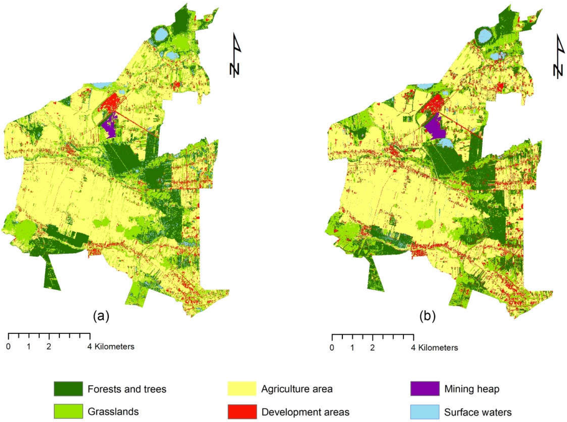
Figure 9 and Table 5 show the changes in the land cover in the Puchaczów commune in the analyzed period of time. Compared to 2012, the expansion of built-up areas is noticeable in 2020. Their area increased from 5.13 km2 to 8.17 km2. The new buildings mainly occupied areas along communication routes, previously developed as agricultural areas. An increase in the occupied area was also recorded in the case of forests and trees. In 2012, these areas accounted for 18.2% of the entire commune, and in 2020 it was 20.45%. The increase in the area of these areas is in line with the nationwide trends [61]. It is worth noting, however, that the forest cover in the Puchaczów commune is below the national average, which for 2020 was 29.6% [62]. In 2012, the estimated area of the mining heap was 0.45 km2. In 2020, this value increased to 0.70 km2. This means that within 8 years this area increased its area by over 50%. The reduction in the occupied area was recorded in three types of land cover: agricultural areas, grasslands, and surface waters. The largest decrease in the area occurred in the case of agricultural land. In 2012, they occupied more than half of the Puchaczów commune. In the following years, they decreased their area to 44.81 km2 (48.97%). It proves the progressive process of abandoning agriculture towards non-agricultural activities. Moreover, the decrease in the acreage of agricultural land is related to the expansion of building zones and the progressing process of rural urbanization. A large change in cover was also noticed in grasslands. In the previous years, they covered 19.54 km2, and in 2020 as much as 17.20 km2. The reason for this is, among others, inappropriate use and care of these areas. The area occupied by surface waters also decreased (from 2.57% to 2.08%), which is a result of overgrowing water reservoirs. Mining activity also influences quantitative and qualitative changes in the hydrosphere. The process of hard coal extraction causes a number of changes related to the topography, which results in the formation of, inter alia, ground depressions. The existence of subsidence basins may cause flooding of neighboring areas, as well as soil drainage and lowering of the groundwater level [63].
5.3. Forecasts of Land Cover in the Puchaczów Commune for the Year 2050
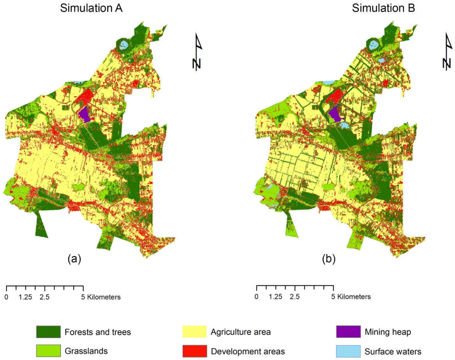
The forecasts of land cover in the Puchaczów commune for 2050 generated with the use of a MOLUSCE plugin are presented in Figure 10. Simulation A was performed on the basis of changes in the forms of land development in 2012–2020. On the other hand, simulation B shows the probable development of a commune in the case of introducing the guidelines of the “perfect village” model. The comparison of the size of individual land cover forms for both forecasts is presented in Table 6.
Comparing simulation A to the land cover from 2020 (Figure 9b), a further trend of increasing the built-up area can be noticed, which in 2050 may reach the value of 16.51 km2. This is 18.04% of the entire commune. The buildings will continue to develop along the main communication routes, extending to the areas previously used for agriculture. Moreover, it will be characterized by an increasingly compact form. It is worth emphasizing that the uncontrolled development of these areas is associated with semi-urbanization, displacement of traditional rural buildings and the emergence of the so-called rurban community. In the future, this may result in the disappearance of specific rural features of the commune, which constitute its unique values. In 2050, forest and wooded areas may grow up to 21.49%. Currently, the national program for increasing forest cover is being carried out in Poland. It’s the main goal of which is to optimize the spatial and temporal distribution of afforestation. The program assumes that in 2050 the country’s forest cover will amount to 33% [58]. This means that in the future, despite the increase in the area of forest complexes, the value of forest cover in the Puchaczów commune will be lower than the national average. According to forecast A, a decrease in agricultural areas is likely, the area of which may amount to 40.48 km2 (44.25%). A drop in the volume was also recorded in the case of grasslands (14.06%), surface waters (1.47%) and, what is worth emphasizing, in the mining waste storage zone (0.69).
Taking into account the guidelines of the “ideal village” model, the forecast of land cover forms for 2050 looks different. A comparative analysis of simulations A and B has showed that by applying the principles of shaping the natural system of the Puchaczów commune presented in the article, it is possible to stop the pressure of growing development areas. Simulation B has showed that in 2050 these areas can reach a value of 13.18 km2, which will constitute 14.40% of the commune’s area, and not 18.04%, as in the case of A simulation. According to simulation B, the amount of land used for agriculture will decrease. However, unlike in the case of the first forecast, it is not a result of the expansion of buildings. The change in the area of agricultural land results from the development of mid-field shelterbelts along the main communication routes and the increase in the area of grasslands. With the application of the guidelines of the “ideal village” in 2050, it is possible to reduce the size of the mining heap to 0.59 km2. Its area would turn into meadows and trees, which is part of the planned rehabilitation. Compared to simulation A, it is likely to achieve greater forest cover in the commune (26.66%) and grassland (16.46). This is related to the strengthening of ecological patches and corridors, as well as the reconstruction of the most anthropogenically transformed zones, proposed in the “ideal village” model. It is also worth emphasizing that forecast B provides for a greater range of surface waters. This means that water reservoirs will not be subject to such strong eutrophication processes, and the northernmost areas will not lose their high natural values.
6. Discussion
Forecasts of changes in the landscape of the Puchaczów commune made in this article takes into account only physical elements, i.e., distance from roads and DEM. It should be noted, however, that the shaping of the territory of the studied area is also greatly influenced by social factors and the spatial development policy. According to the simulations, in 2050 a decrease in the mining heap is forecast. It is not compliant with the currently binding planning and strategic documents. In 2012, Bogdanka S.A obtained a permit for the extension of the mining waste neutralization facility (L.Dz.LUB/02/35/56/11/12/MS). The above was connected with the necessity to introduce changes to the local spatial development plan of the Puchaczów commune [64]. The mining heap is to reach 95 ha of area and 80 m relative height. The waste storage zone will occupy the areas of the forest complex, meadows and arable lands (Figure 11). The adjacent forests and grasslands constitute fragments of ecological patches and corridors, characterized by a low degree of flora anthropization. These areas should be part of the Ecological System of Protected Areas (pol. ESOCH), however, due to the planned expansion of the repository, they were not covered by protection. The above will result in the interruption of the continuity of the existing ecological structures, the reconstruction of which after the reclamation of the heap may be long or even impossible.
In 2019, the Bogdanka S.A. mine submitted an application to the Regional Director for Environmental Protection (pol. RDOŚ) in Lublin for the amendment of concessions No. 5/2009 and 3/2014, which was approved. This action was aimed at extending the possibility of extracting coal in the “Puchaczów V” and “Stręczyn” mining areas. Society for Nature and Man appealed against the above decision to the General Director for Environmental Protection (pol. GDOŚ), no obligations of the investor to implement the revitalization of areas in the event of their transformation as a result of mining activities and overlapping investments in areas of natural value. GDOŚ determined that the Regional Directorate of Environmental Protection in Lublin violated the formal law, which resulted in an inadequate explanation of the planned environmental investment. Therefore, GDOŚ revoked the decision to extend the license and submitted it for re-examination [65]. Mining activity is classified as a project that can have a significant impact on the environment [66]. If the aforementioned concessions are extended in the territory of the Puchaczów commune, further, unfavorable and unpredictable changes to the landscape will most likely occur, resulting from the intensification of the mining industry development. It should be emphasized here that economic conditions should not be confronted with the ecological ones. If the issue of protection and appropriate shaping of natural resources is neglected, even the richest areas will not be an “ideal” place to live in.
7. Conclusions
On the basis of the model created for the Puchaczów commune presented in the article, the main principles of shaping the “ideal village” can be distinguished:
- The basis for identifying appropriate guidelines for shaping the natural systems of rural areas are landscape studies, including the study of vegetation.
- Shaping the “perfect village” should begin with the identification of the most problematic areas (to the greatest extent degraded by human activity), because they require special measures to reduce their negative impact on the environment. Such zones should be isolated by plantings in the ring system, creating a specific gradient between the conflict areas and the neighboring areas. In the case of industrial development, an important issue is to plan the reclamation process, which is also related to the appropriate selection of plants.
- In agricultural areas that require reconstruction of spatial systems, it is necessary to rebuild or create new field plantings. They should have a stripe form, creating a network of trees.
- The activities of reconstruction and strengthening of natural systems planned as part of the “perfect village” should aim at rebuilding the continuity of ecological structures. This can be achieved by creating new plantings, for example, along water courses, establishing flower meadows and afforestation.
- The process of securing natural systems is not only related to environmental protection, but also to monitor and control the changes that take place in it.
The study of vegetation is an important stage in the preparation of the program of shaping the natural environment of the commune, especially in the case of polyfunctional areas. Protection, strengthening and reconstruction of natural systems will allow us to assess the appropriate management methods and determine the appropriate directions of transformations of plant cover to strengthen the natural environment. The proposed concept of a “perfect village” is an example of a model solution for sustainable development for this type of area.
Supplementary Materials
The following supporting information can be downloaded at: https://www.mdpi.com/article/10.3390/su142114479/s1.
Author Contributions
Conceptualization, S.B.; formal analysis, S.B.; methodology, S.B.; supervision, M.M.; visualization, S.B.; writing—original draft, S.B. and M.M. All authors have read and agreed to the published version of the manuscript.
Funding
The article was financed by a subsidy for the maintenance of the research potential granted by the Dean of the Faculty of Horticulture and Landscape Architecture and the funds of the Department of Landscape Architecture.
Informed Consent Statement
Not applicable.
Data Availability Statement
Not applicable.
Conflicts of Interest
The authors declare no conflict of interest.
References
- Paszkowski, Z. Miasto Idealne w Perspektywie Europejskiej i Jego Związki z Urbanistyką Współczesną; Universitas: Kraków, Poland, 2012; pp. 17–19. [Google Scholar]
- Szpakowska, E. Atlas miast idealnych. XVI—XVIII wiek. Przestrz. I Forma 2012, 17, 165–188. [Google Scholar]
- Zelenika, I.; Pearce, J. Barriers to Appropriate Technology Growth in Sustainable Development. Eur. J. Sustain. Dev. 2011, 4, 12–22. [Google Scholar] [CrossRef]
- Wanner, A.; Pröbstl-Haider, U. Barriers to Stakeholder Involvement in Sustainable Rural Tourism Development—Experiences from Southeast Europe. Sustainability 2019, 11, 3372. [Google Scholar] [CrossRef] [Green Version]
- Panorama, M. Barriers on Rural Development in Musi Banyuasin (MUBA) District, South Sumatera, Indonesia. J. Econ. Manag. Perspect. 2018, 12, 542–551. [Google Scholar]
- Burja, C.; Burja, V. Sustainable development of rural areas: A challenge for Romania. Environ. Eng. Manag. J. 2014, 13, 1861–1871. [Google Scholar] [CrossRef]
- Dąbrowski, A.; Górska, D.; Świstak, P.; Gunia, A.; Sokalska, K. Bariery zrównoważonego rozwoju obszarów wiejskich w Polsce. Syst. Wspomagania W Inżynierii Prod. 2019, 8, 70–82. [Google Scholar]
- Mickiewicz, B.; Jurczak, R. Barriers to the Development of Green Economy in Rural Areas of Selected Districts of the Greater Poland Province. Eur. Res. Stud. J. 2021, 24, 314–324. [Google Scholar] [CrossRef]
- Skubiak, B. Rola programu Leader w rozwoju obszarów wiejskich w Polsce. In Zrównoważony Rozwój Obszarów Wiejskich, Wybrane Aspekty Społeczne; Kryk, B., Ed.; Uniwersytet Szczeciński, Katedra Polityki Społeczno-Gospodarczej i Europejskich Studiów Regionalnych: Szczecin, Poland, 2010; pp. 165–184. [Google Scholar]
- Dumitru, E.A.; Ursu, A.; Tudor, V.C.; Micu, M.M. Sustainable Development of the Rural Areas from Romania: Development of a Digital Tool to Generate Adapted Solutions at Local Level. Sustainability 2021, 13, 11921. [Google Scholar] [CrossRef]
- Przygodzka, R. Zrównoważony rozwój obszarów wiejskich. In Od Koncepcji Ekorozwoju do Ekonomii Zrównoważonego Rozwoju; Kiełczewski, D., Ed.; Wydawnictwo Wyższej Szkoły Ekonomicznej w Białymstoku: Białystok, Poland, 2009; p. 260. [Google Scholar]
- Qi, L.; Liu, R.; Cui, Y.; Zhou, M.; Bonenberg, W.; Song, Z. Study of the Landscape Pattern of Shuiyu Village in Beijing, China: A Comprehensive Analysis of Adaptation to Local Microclimate. Sustainability 2022, 14, 375. [Google Scholar] [CrossRef]
- Viccaro, M.; Caniani, D. Forest, Agriculture, and Environmental Protection as Path to Sustainable Development. Nat. Resour. Res. 2019, 28, 1–4. [Google Scholar] [CrossRef] [Green Version]
- Koreleski, K. Ochrona i kształtowanie terenów rolniczych w systemie kreowania krajobrazu wiejskiego. Infrastrukt. I Ekol. Teren. Wiej. 2009, 4, 5–20. [Google Scholar]
- Niedźwiecka-Filipiak, I.; Gubański, J.; Bocheńska-Skałecka, A.; Kuriata, Z. Rola wyróżników krajobrazu wiejskiego w procesie rewitalizacji wsi. Stud. Obsz. Wiej. 2018, 49, 93–108. [Google Scholar] [CrossRef]
- Niedźwiecka-Filipiak, I.; Kuriata, Z. Ochrona i kształtowanie krajobrazu wsi w pracach Instytutu Architektury Krajobrazu Uniwersytetu Przyrodniczego we Wrocławiu. Archit. Kraj. 2012, 2, 90–98. [Google Scholar]
- Baster, P.; Litwin, U. Polish Rural Designing System Used for the Implementation of the Ideas of Green Deal and Sustainability—Comparison of Landscape and Agricultural Areas Planning, on the Example of Strzelce Wielkie and Kamionka Wielka. Sustainability 2021, 13, 886. [Google Scholar] [CrossRef]
- Brundtland, G. Report of the World Commission on Environment and Development. In Our Common Future; United Nations General Assembly Document A/42/427; Oxford University Press: Oxford, UK, 1987. [Google Scholar]
- Gutowski, B. Przestrzeń Marzycieli Miasto Jako Projekt Utopijny; Oficyna Wydawnicza Feniks: Warszawa, Poland, 2006; pp. 52–54, 89–121. [Google Scholar]
- Rainer Zenz on de.wikipedia—vgl. dazu eine farbige Abb. in: dtv-Atlas zur Baukunst, Bd.2, 4.Auflage, 1985, s. 432, Public Domain. Available online: https://commons.wikimedia.org/w/index.php?curid=1020913 (accessed on 10 June 2022).
- Patnaik, S.; Sen, S.; Mahmoud, M.S. Smart Village Technology. Concepts and Development; Springer: Cham, Switzerland, 2020; pp. 7–9. [Google Scholar]
- Adamowicz, M.; Zwolińska-Ligaj, M. The “Smart Village” as a Way to Achieve Sustainable Development in Rural Areas of Poland. Sustainability 2020, 12, 6503. [Google Scholar] [CrossRef]
- Visvizi, A.; Lytras, M.D. It’s Not a Fad: Smart Cities and Smart Villages Research in European and Global Contexts. Sustainability 2018, 10, 2727. [Google Scholar] [CrossRef] [Green Version]
- The European Network for Rural Development (ENRD)-European Commission. Available online: https://enrd.ec.europa.eu/smart-and-competitive-rural-areas/smart-villages/smart-villages-portal_en (accessed on 14 June 2022).
- The European Network for Rural Development. Smart Villages: Revitalising rural services. EU Rural. Rev. 2018, 26, 10–11. Available online: https://enrd.ec.europa.eu/publications/eu-rural-review-26-smart-villages-revitalising-rural-services_en (accessed on 4 May 2022).
- Kusio, T.; Rosiek, J.; Conto, F. Urban–Rural Partnership Perspectives in the Conceptualization of Innovative Activities in Rural Development: On Example of Three-Case Study Analysis. Sustainability 2022, 14, 7309. [Google Scholar] [CrossRef]
- Zhang, X.; Zhang, Z. How Do Smart Villages Become a Way to Achieve Sustainable Development in Rural Areas? Smart Village Planning and Practices in China. Sustainability 2020, 12, 10510. [Google Scholar] [CrossRef]
- Stojanova, S.; Lentini, G.; Niederer, P.; Egger, T.; Cvar, N.; Kos, A.; Stojmenova Duh, E. Smart Villages Policies: Past, Present and Future. Sustainability 2021, 13, 1663. [Google Scholar] [CrossRef]
- A Framework for Information and Communications Technology Policy Reviews. Available online: https://unctad.org/webflyer/framework-information-and-communications-technology-policy-reviews (accessed on 14 June 2022).
- Zavratnik, V.; Kos, A.; Stojmenova Duh, E. Smart Villages: Comprehensive Review of Initiatives and Practices. Sustainability 2018, 10, 2559. [Google Scholar] [CrossRef] [Green Version]
- Ramesh, R.; SivaRam, P. The idea of a model village: Towards developing a framework to the study of model villages. J. Rural. Dev. 2019, 38, 525–540. [Google Scholar] [CrossRef]
- Goswamy, P.; Adhikari, B. Concept of model villages and agriculture in its core. Food Sci. Rep. 2021, 2, 49–51. [Google Scholar]
- Ministry of Tribal Affairs. Available online: https://tribal.nic.in/Model-village.aspx (accessed on 14 June 2022).
- Ekins, P.; Zenghelis, D. The costs and benefits of environmental sustainability. Sustain. Sci. 2021, 16, 949–965. [Google Scholar] [CrossRef]
- Agovino, M.; Casaccia, M.; Ciommi, M.; Ferrara, M.; Marchesano, K. Agriculture, climate change and sustainability: The case of EU-28. Ecol. Indic. 2019, 105, 525–543. [Google Scholar] [CrossRef]
- Djufry, F.; Wulandari, S. Climate-Smart Agriculture Implementation Facing Climate Variability and Uncertainty in the Coffee Farming System. In Proceedings of the 2nd International Conference on Sustainable Agriculture for Rural Development 2020, Purwokerto, Indonesia, 20 October 2020. [Google Scholar]
- Shahzad, M.F.; Abdulai, A.; Issahaku, G. Adaptation Implications of Climate-Smart Agriculture in Rural Pakistan. Sustainability 2021, 13, 11702. [Google Scholar] [CrossRef]
- Sullivan, A.; Mumba, A.; Hachigonta, S.; Connolly, M.; Sibanda, L.M. Climate Smart Agriculture: More Than Technologies Are Needed to Move Smallholder Farmers Toward Resilient and Sustainable Livelihoods. Food Agric. Nat. Resour. Policy Netw. 2012, 13, 1–4. [Google Scholar]
- Onyeneke, R.U.; Igberi, C.O.; Uwadoka, C.O.; Aligbe, J.O. Status of climate-smart agriculture in southeast Nigeria. GeoJournal 2018, 83, 333–346. [Google Scholar] [CrossRef]
- Stachowicz, S. Zagadnienia wielkości produkcji i jakości węgla w planach rozwojowych Lubelskiego Węgla Bogdanka S.A. Polityka Energetyczna 2005, 5, 623–635. [Google Scholar]
- Mącik, E.; Świerczyńska, A.; Gajos, J.; Laskowski, T.; Pomorski, E.; Żaliński, J.; Czopek, J.; Wiącek, W.; Filas, P.; Butryński, P. Studium uwarunkowań i kierunków zagospodarowania przestrzennego gminy Puchaczów. Załącznik Nr 1 do Uchwały Nr XXXIII/226/21 Rady Gminy Puchaczów z dnia 7 maja 2021 r., EM Biuro Projektów Urbanistyki i Architektury, Lublin, Poland 2021. Available online: https://www.puchaczow.pl/asp/studium-uwarunkowan-i-kierunkow-zagospodarowania-przestrzennego-gminy-puchaczow,8,artykul,28,2908 (accessed on 1 May 2022).
- Sprawozdanie Zarządu z działalności LW Bogdanka S.A. oraz Grupy Kapitałowej LW Bogdanka za 2021r. Available online: https://ri.lw.com.pl/szczegoly-raportu-PER?irr_id=2422 (accessed on 1 July 2022).
- Barwicka, S. Rural landscape analyses as a spatial planning tool on the example of the Puchaczów Commune. Ann. Wars. Univ. Life Sci.—SGGW. Hortic. Landsc. Archit. 2021, 42, 103–116. [Google Scholar] [CrossRef]
- Matuszkiewicz, J.M. Potential Natural Vegetation of Poland; IGiPZ PAN: Warszawa, Poland, 2008. [Google Scholar]
- Szefler, S. The method of determining research units for the needs of valorisation of rural landscape at the level of plant cover on the example of the Puchaczów commune. Acta Sci. Pol. Adm. Locorum 2021, 20, 35–46. [Google Scholar] [CrossRef]
- Plit, J. Antropogeniczne i Naturalne Przeobrażenia Krajobrazów Roślinnych MAZOWSZA (od Schyłku XVIII w. do 1990 r.); Continuo: Wrocław, Poland, 1996; p. 46. [Google Scholar]
- Available online: https://pro.arcgis.com/es/pro-app/2.7/get-started/get-started.htm (accessed on 2 April 2022).
- Available online: https://qgis.org/pl/site/forusers/download.html (accessed on 2 April 2022).
- Kucharski, L. Szata roślinna terenu górniczego złoża Koźmin—jej zmiany i możliwości ochrony. Pr. I Stud. Geogr. 2010, 44, 169–192. [Google Scholar]
- Available online: https://plugins.qgis.org/plugins/molusce/ (accessed on 2 April 2022).
- Kamaraj, M.; Rangarajan, S. Predicting the Future Land Use and Land Cover Changes for Bhavani Basin, Tamil Nadu, India Using QGIS MOLUSCE Plugin. Environ. Sci. Pollut. Res. 2021. [Google Scholar] [CrossRef] [PubMed]
- Rizwan, M.; Zhang, W.; Abbas, Z.; Guo, F.; Gwiazdzinski, L. Spatiotemporal Change Analysis and Prediction of Future Land Use and Land Cover Changes Using QGIS MOLUSCE Plugin and Remote Sensing Big Data: A Case Study of Linyi, China. Land 2022, 11, 419. [Google Scholar] [CrossRef]
- The Act of April 27, 2001, Environmental Protection Law. J. Laws 2001, 62, 627.
- Act of February 3, 1995 on the protection of agricultural and forest land. J. Laws 1995, 16, 78.
- The Act of 10 July 2008 on mining waste. J. Laws 2008, 138, 865.
- Lubelski Węgiel Bogdanka Spółka Akcyjna. Gospodarka odpadami. Available online: https://www.lw.com.pl/pl,2,d1097,gospodarka_odpadami.html (accessed on 2 June 2022).
- Przesmycka, N.; Przesmycka, E.; Koziołek, J.E.; Łyszczarz, L.; Kamińska-Wawryszuk, M. Koncepcja rekultywacji i docelowego zagospodarowania składowiska odpadów górniczych w Lubelskim Węglu „Bogdanka” SA. Wiadomości Górnicze 2013, 64, 684–690. [Google Scholar]
- Chodak, M. Metody Rekultywacji i Zagospodarowania Obszarów Poeksploatacyjnych w Górnictwie Skalnym; Poltegor-Instytut Instytut Górnictwa Odkrywkowego: Wrocław, Poland, 2013; pp. 69–74. [Google Scholar]
- Ryszkowski, L.; Batazy, S.; Jankowiak, J. Program zwiększania zadrzewień śródpolnych. Postępy Nauk. Rol. 2000, 5, 83–107. [Google Scholar]
- EKSPERT—Dobór Gatunków do Zadrzewień. Available online: http://zadrzewienia.wl.sggw.pl/Zadrzewienia.htm (accessed on 20 June 2022).
- Lasy Państwowe. Available online: https://www.lasy.gov.pl/pl/nasze-lasy/polskie-lasy (accessed on 20 June 2022).
- GUS. Statistical Yearbook of Forestry; GUS: Warszawa, Poland, 2021; p. 37. [Google Scholar]
- Kraśnicki, S. Oddziaływanie Projektowanej Kopalni Węgla Kamiennego Eksploatującej złoże Lublin na Wody Podziemne i Powierzchniowe; Centrum Ochrony Mokradeł: Ludów Polski, Poland, 2019; Typescript. [Google Scholar]
- Uchwała nr XXVIII/176/17 rady gminy Puchaczów z dnia 25 stycznia 2017 r. w sprawie uchwalenia zmiany miejscowego planu zagospodarowania przestrzennego gminy Puchaczów na terenie górniczym obszaru górniczego Puchaczów V w zakresie trasy przebiegu estakady taśmowej napowietrznej do transportu urobku z pola Stefanów do Bogdanki, lokalizacji składowiska węgla oraz przestrzennego rozmieszczenia składowiska odpadów górniczych (obiektu unieszkodliwiania odpadów wydobywczych) wraz z zapleczem techniczno—maszynowym. Available online: https://ugpuchaczow.bip.e-zeto.eu/index.php?type%3D4%26name%3Dbt29%26func%3Dselectsite%26value%255B0%255D%3D1031 (accessed on 4 June 2022).
- Generalny Dyrektor Ochrony Środowiska, Decyzja nr DOOŚ-WDŚZOO.420.578.2019.AB/MM.13. Available online: https://www.gov.pl/web/gdos/decyzja-generalnego-dyrektora-ochrony-srodowiska-z-dnia-3-marca-2022-r-znak-doos-wdszoo4205782019abmm13 (accessed on 2 June 2022).
- Rozporządzenie Rady Ministrów z dnia 10 września 2019 r. w sprawie przedsięwzięć mogących znacząco oddziaływać na środowisko. Dz.U. 2019 poz. 1839/The Regulation of the Council of Ministers of September 10, 2019 on environmental impact may be addressed to the environment. J. Laws 2019, 1839.
Figure 1.
Sforzinda City Plan [20].
Figure 1.
Sforzinda City Plan [20].

Figure 2.
Location of the study area: (a) against the background of the country and voivodship; (b) against the background of the poviat.
Figure 2.
Location of the study area: (a) against the background of the country and voivodship; (b) against the background of the poviat.

Figure 3.
Potential natural vegetation in Puchaczów commune (comp. own based on [41]).
Figure 3.
Potential natural vegetation in Puchaczów commune (comp. own based on [41]).

Figure 4.
Percentage of plants in terms of geographical and historical groups determined in the Puchaczów commune.
Figure 4.
Percentage of plants in terms of geographical and historical groups determined in the Puchaczów commune.

Figure 5.
Valorization of the landscape of the Puchaczów commune.

Figure 6.
Research stages and the thematic scope of the issues described in the article.

Figure 7.
Spatial variables used in molusce plugin: (a) DEM; (b) distance from roads.

Figure 8.
“Perfect village” model: (a) type of guidance; (b) specification of the main activities.

Figure 9.
Land cover in the Puchaczów commune: (a) in 2012; (b) in 2020.

Figure 10.
Simulations of land cover in Puchaczów commune in 2050: (a) without changes; (b) when introducing the “perfect village” model.
Figure 10.
Simulations of land cover in Puchaczów commune in 2050: (a) without changes; (b) when introducing the “perfect village” model.

Figure 11.
The planned area of the heap (comp. own based on [38]).
Figure 11.
The planned area of the heap (comp. own based on [38]).

Table 1.
Scale of evaluation of landscape anthropization (comp. own based on [46]).
Table 1.
Scale of evaluation of landscape anthropization (comp. own based on [46]).
| Vegetation Anthropization Class | Valuation Scale |
|---|---|
| Final communities: forest and non-forest | 1 |
| Natural communities with disturbed species structure | 2 |
| Offshore forests, natural succession scrub communities and unused grass communities | 3 |
| Mowing grasslands and pastures | 4 |
| Forests planted in an unsuitable habitat | 5 |
| Secondary forest and shrub communities and young forests | 6 |
| Synatropic communities with a well-developed characteristic combination of species | 7 |
| Segetal (field) communities | 8 |
| Synatropic hull communities | 12 |
| Lack of vegetation due to human activity | 20 |
Table 2.
The method of determining the guidelines for shaping the “perfect village”.
| Degree of Anthropization | Type of Guidance | Description |
|---|---|---|
| 1–3 | Protection | Areas with the greatest natural values. Activities related to the selection of areas currently subject to environmental protection or requiring it. Monitoring changes taking place in the landscape, including plant cover. |
| 3–6 | Strengthening | Areas characterized by an average degree of anthropization. Shaping natural systems related to proper care and rational land use. Afflictions, plantings taking into account native vegetation, reconstruction of corridors and ecological patches. |
| 7–20 | Reconstruction | The areas most severely changed as a result of human activity—arable fields, urbanized areas, industrial zone. Introduction of activities related to the need to change the natural system by creating a network of new plantings of native plants and the selection of special-purpose plants, including the recultivation of post-industrial areas. |
Table 3.
Method of assigning the type “ideal village” guidelines to individual areas.
| Land Use | Description |
|---|---|
| Forests and trees | Deciduous, coniferous and mixed forests, groups of trees accompanying the buildings, mid-field, linear |
| Grasslands | Meadows and pastures, wastelands |
| Agriculture area | Crops |
| Development areas | Residential, service and industrial buildings, road and railway infrastructure |
| Mining heap | Post-industrial waste landfill |
| Surface waters | Artificial and natural water reservoirs |
Table 5.
Land use changes in 2012–2020.
| Land Use | 2012 | 2020 | Δ | 2012% | 2020% | Δ % |
|---|---|---|---|---|---|---|
| Forests and trees | 16.65 km2 | 18.71 km2 | 2.06 km2 | 18.2 | 20.45 | 2.25 |
| Grasslands | 19.54 km2 | 17.20 km2 | −2.34 km2 | 21.36 | 18.8 | −2.56 |
| Agriculture area | 47.18 km2 | 44.81 km2 | −2.37 km2 | 51.57 | 48.97 | −2.6 |
| Development areas | 5.31 km2 | 8.17 km2 | 2.86 km2 | 5.8 | 8.93 | 3.13 |
| Mining heap | 0.45 km2 | 0.70 km2 | 0.25 km2 | 0.5 | 0.77 | 0.27 |
| Surface waters | 2.35 km2 | 1.90 km2 | −0.45 km2 | 2.57 | 2.08 | −0.49 |
Table 6.
Comparison of the area of land cover forms of simulations A and B.
| Land Use | Simulation A | Simulation B | Δ | Simulation A% | Simulation B% | Δ % |
|---|---|---|---|---|---|---|
| Forests and trees | 19.66 km2 | 24.40 km2 | 4.74 km2 | 21.49 | 26.66 | 5.17 |
| Grasslands | 12.86 km2 | 15.06 km2 | 2.20 km2 | 14.06 | 16.46 | 2.40 |
| Agriculture area | 40.48 km2 | 36.02 km2 | −2.37 km2 | 44.25 | 39.37 | −4.87 |
| Development areas | 16.51 km2 | 13.18 km2 | −3.33 km2 | 18.04 | 14.40 | −3.64 |
| Mining heap | 0.63 km2 | 0.59 km2 | −0.04 km2 | 0.69 | 0.65 | −0.04 |
| Surface waters | 1.35 km2 | 2.24 km2 | 0.89 km2 | 1.47 | 2.45 | 0.98 |
Publisher’s Note: MDPI stays neutral with regard to jurisdictional claims in published maps and institutional affiliations. |
© 2022 by the authors. Licensee MDPI, Basel, Switzerland. This article is an open access article distributed under the terms and conditions of the Creative Commons Attribution (CC BY) license (https://creativecommons.org/licenses/by/4.0/).
Share and Cite
MDPI and ACS Style
Barwicka, S.; Milecka, M. The “Perfect Village” Model as a Result of Research on Transformation of Plant Cover—Case Study of the Puchaczów Commune. Sustainability 2022, 14, 14479. https://doi.org/10.3390/su142114479
AMA Style
Barwicka S, Milecka M. The “Perfect Village” Model as a Result of Research on Transformation of Plant Cover—Case Study of the Puchaczów Commune. Sustainability. 2022; 14(21):14479. https://doi.org/10.3390/su142114479
Chicago/Turabian StyleBarwicka, Sylwia, and Małgorzata Milecka. 2022. "The “Perfect Village” Model as a Result of Research on Transformation of Plant Cover—Case Study of the Puchaczów Commune" Sustainability 14, no. 21: 14479. https://doi.org/10.3390/su142114479
Note that from the first issue of 2016, this journal uses article numbers instead of page numbers. See further details here.