How MapInfo Pro Utilizes AI
Polaris Digitech Limited
We are a dominant Pan-African Location Intelligence firm based in Lagos NG
MapInfo, a geographic information system (GIS) software developed by Pitney Bowes, is a spatial data analysis, visualization, and decision-making tool that incorporates AI capabilities to enhance and streamline various tasks. Here are some ways MapInfo utilizes AI:
1. Image Recognition: MapInfo leverages AI algorithms to analyze and interpret aerial and satellite images. Through image recognition, it can automatically identify and categorize objects such as buildings, roads, water bodies, and vegetation. This automated process helps in efficiently updating and maintaining accurate spatial data.
2. Data Cleaning and Validation: MapInfo employs AI algorithms to automatically clean and validate geospatial datasets. It identifies data inconsistencies, duplicates, outliers, and missing values, enabling users to ensure data integrity and improve the accuracy of their analyses and visualizations.
3. Predictive Analytics: Using AI techniques like machine learning, MapInfo can perform predictive analytics on spatial data. It can analyze historical data patterns and trends to make forecasts and predictions about future events, such as urban growth, consumer behavior, or transportation demand.
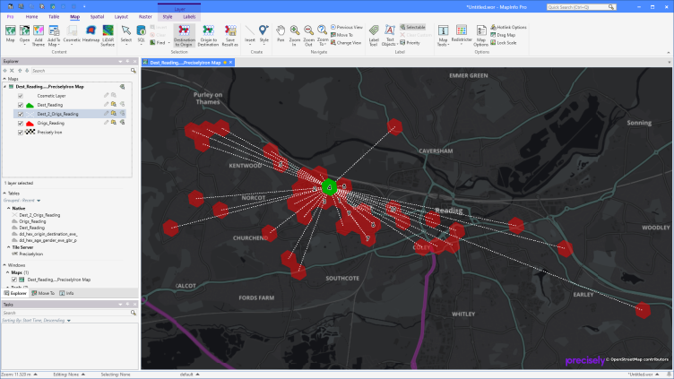
4. Routing and Network Analysis: AI algorithms are utilized in MapInfo's network analysis tools to optimize route planning. It can calculate the most efficient routes based on various factors such as traffic conditions, road types, and distance. This ensures better navigation and resource allocation for logistics, transportation, and emergency response purposes.
5. Spatial Data Visualization: MapInfo incorporates AI-based visualization techniques to help users explore and understand spatial data more effectively. It can automatically generate thematic maps, heatmaps, and other visual representations of data. This aids in quickly identifying spatial patterns, clusters, and correlations, enabling better decision-making.
6. Geocoding and Address Matching: MapInfo employs AI algorithms to enhance geocoding and address matching capabilities. It can accurately match incomplete or misspelled addresses to their corresponding geographic locations, making it easier to integrate external datasets and geolocate addresses in spatial analysis tasks.
Overall, MapInfo utilizes AI to automate and streamline various aspects of spatial data analysis, visualization, and management. By harnessing AI capabilities, users can save time, improve accuracy, and gain valuable insights from their geospatial data.