Uphill
446m

Length
17km
Duration
6h
Elev gain
446m
This new stage contrasts greatly with the two previous ones. No more heights, make way for valleys and charming historic villages.
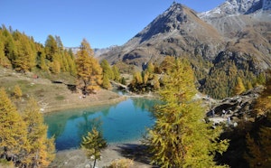
The path begins by leaving Arolla and following the valley of the same name, where it is possible to make a detour to see the very beautiful Lac Bleu.
The rest of the day is dedicated to crossing several villages that form the cultural heart of the Val d'Hérens: Les Haudères, La Forclaz, La Sage, then Evolène. Old houses, flower meadows, and local products, give an authentic charm to this little corner of paradise.

Already more than 200,000 users!
Uphill
446m
Highest point
2022m
Downhill
1094m
Lowest point
1367m
Route type
One way
Download the map on your smartphone to save battery and rest assured to always keep access to the route, even without signal.
Includes IGN France and Swisstopo.
I indicate whether dogs are allowed or prohibited on this trail
From May to September
0 ratings
Also enjoy:

Already more than 200,000 users!